

Seattle weather: Fewer showers Sunday with brighter moments ahead

More cloudy, rainy days through the next week
FOX 13 Meteorologist Abby Acone is tracking another doozy of a week—be prepared for more clouds and rain!
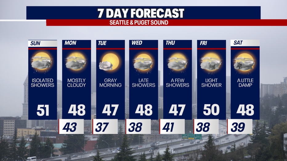
SEATTLE - After another soaking day Saturday, far fewer showers are on tap for today. Monday will be drier (but still cloudy).

Highs today will reach for the upper 40s to low 50s. Mostly cloudy skies are in the forecast. We'll be dodging isolated showers.
The threat of landslides is also high around Western Washington today and tomorrow. Soils are saturated and unstable after rounds of heavy rain have swept through the region.
Because of our parade of storms and wet weather, river levels are running higher than usual. There's a Flood Warning in effect today for the Skokomish River in Mason County. Parts of the Newaukum, Chehalis, Snoqualmie and Snohomish Rivers will approach flood stage. A Flood Watch has been posted for much of Southwest Washington from 1 p.m. today through Monday night.


The Summit at Snoqualmie and Stevens Pass are reporting a foot and 15 inches respectively in the last 24 hours (as of this morning). The sad news is that a lot of this freshly-accumulated snow could melt today as snow levels jump to 6,000 feet in elevation and milder air moves in. After difficult driving conditions over the passes overnight, only isolated showers are expected today: the precipitation under 6,000 feet should be in the form of rain during the daytime. Late tonight, snow levels may briefly drop as low as 4,500 feet - which is right around the elevation of White Pass. Little to no accumulations are expected.
As we look at our mountain snowpack so far and how it comes to normal – you can see we're clearly running below average.
Unfortunately, the risk of avalanches is elevated in the backcountry of the Cascades. For more information, head to the Northwest Avalanche Center.

Tomorrow will be drier albeit cloudy. Fog and spots of freezing fog are possible Tuesday: this layer of low-hanging clouds will be very stubborn. However, some sunbreaks could appear late in the afternoon.
Showers could return Wednesday. We'll be dodging on-and-off showers for the rest of the seven day forecast.
If you'd like to learn more about how exceptionally wet and dark our December has been so far, feel free to visit my social media channels. As always, I love getting your weather comments, questions and storm photos on social media as well!
Thanks so much for choosing FOX 13. It's a pleasure forecasting for you!
Take care,
Meteorologist Abby Acone
Follow me on X @abbyacone, Instagram @abbyaconewx, TikTok @abbyaconetv and Facebook (Meteorologist Abby Acone)