

Get ready for another round of heavy rain, wind and potential flooding!
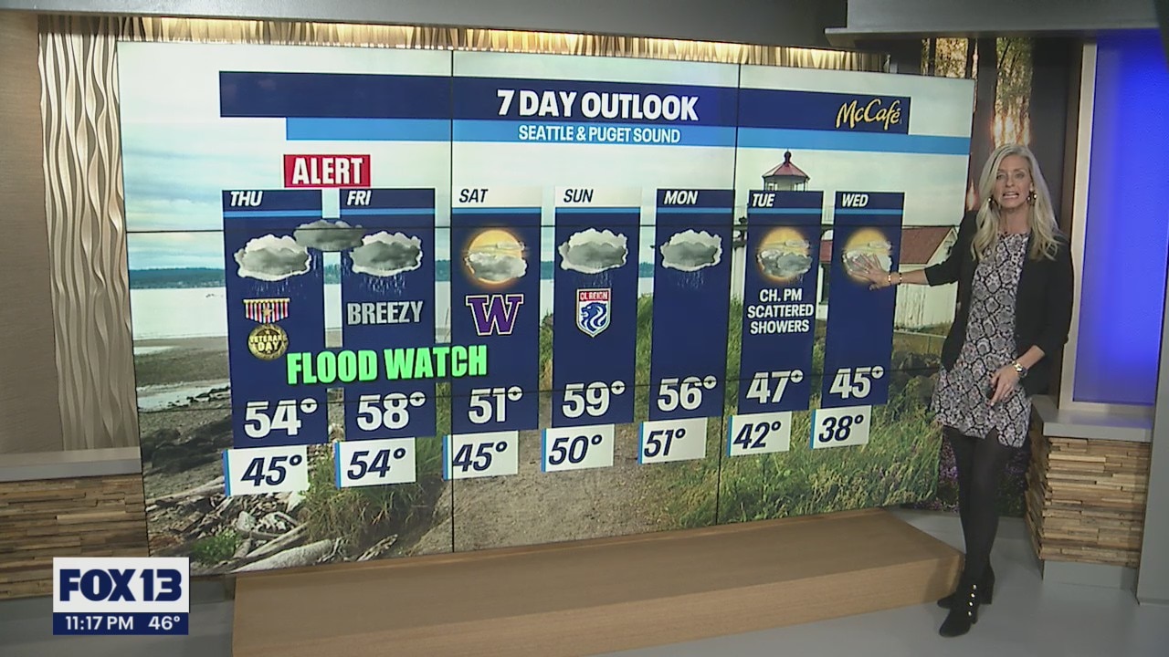
Flood Watch in effect for Thursday and Friday
We expect sharp rises on local rivers with the potential for small streams overflowing creating urban flooding in low-lying areas, roadways, underpasses, and poor drainage areas.
Seattle - We are in for a sloppy close to the work week as another atmospheric river slams into Washington delivering heavy rain and wind Thursday into Friday. And this why the FOX 13 Weather Team is calling for a Weather Alert. The of the rain and wind will happen Thursday afternoon into early Friday morning.

With so much rain falling, and rising snow levels area rivers, streams and creeks will run fast and high. We expect sharp rises on local rivers with the potential for small streams overflowing creating urban flooding in low-lying areas, roadways, underpasses, and poor drainage areas. Be aware of your surroundings.
The risk of landslides across the region will also be a threat as already saturated grounds become even more soggy, Soils will be very unstable during this time increasing movement in the ground.

Heavy rain hits the coast first and then pushes inland by mid-day. Highs will hang in the mid 50s, slightly above average.


A "Flood Watch" goes into effect Thursday afternoon lasting through Saturday afternoon from the Coast to the Cascades along with most of NW Oregon.


Just after dinner Thursday night rain becomes extremely heavy, especially in mountains. We expect 1-3 inches to fall overnight into early Friday morning.

By mid-morning Friday most of us west of the Cascades will start to dry out. Highs will climb into the upper 50s, well of the norm of 53 for this time of year.

We should stay dry most of Saturday which is good news for the UW Football team as they host Arizona State on Montlake. Kick off set for 4pm with temps in the low to mid 50s. Rain pushes in very late Saturday night into early Sunday morning for another good blast of moisture while most of us sleep.

Sunday will be wet at times with continued warmer highs.
Monday sees more showers with temperatures cooling some back into the mid 50s.
And right now, Tuesday and Wednesday look mainly dry, but highs will struggle to get out of the upper 40s.
Have a great night all! ~Erin Mayovsky, FOX 13 Forecaster

*Beach Forecast

*Mountain Forecast


