


More dense fog through the night
The fog is back and here to stay through tomorrow morning. Another dense fog advisory is in effect and visibilities are already below .25 miles for some in the highlighted area below.
The fog is back and here to stay through tomorrow morning. Another dense fog advisory is in effect and visibilities are already below .25 miles for some in the highlighted area below.
More dry weather before rain showers return to Washington
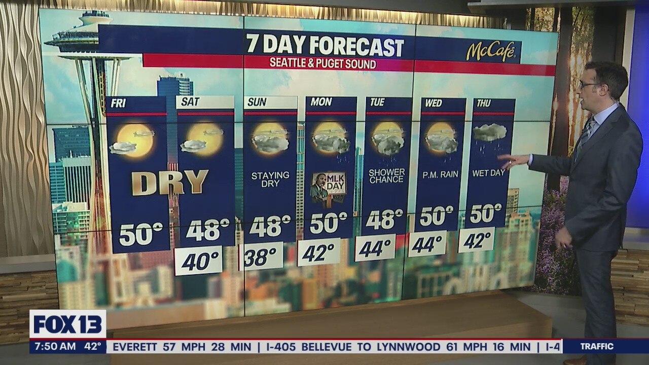
FOX 13 Chief Meteorologist is tracking the return of rain showers in your 7-day forecast. But first more dry weather!
FOX 13 Chief Meteorologist is tracking the return of rain showers in your 7-day forecast. But first more dry weather!


King Co. issued tsunami advisory 'out of an abundance of caution'
King County said they earlier sent out a tsunami advisory emergency alert on Saturday “out of an abundance of caution.”
King County said they earlier sent out a tsunami advisory emergency alert on Saturday “out of an abundance of caution.”


Governors turn to budgets to guard against climate change
Their state budgets flush with cash, Democratic and Republican governors alike want to spend some of the windfall on projects aimed at slowing climate change and guarding against its consequences, from floods and wildfires to dirty air.
Their state budgets flush with cash, Democratic and Republican governors alike want to spend some of the windfall on projects aimed at slowing climate change and guarding against its consequences, from floods and wildfires to dirty air.


What is a tsunami and what causes them?
All coastlines around the world are vulnerable to tsunamis, so it's important to know your community's hazard and evacuation plans in case they're needed.
All coastlines around the world are vulnerable to tsunamis, so it's important to know your community's hazard and evacuation plans in case they're needed.


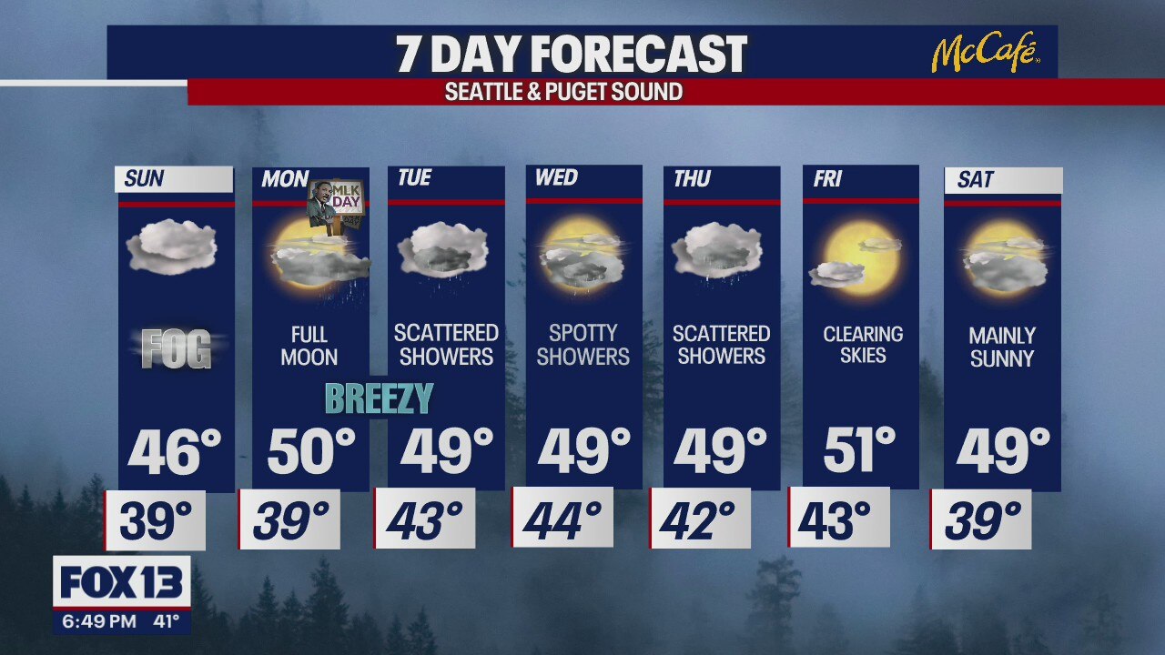
Dry weather giving out to clouds and rain after MLK Day
We're still tracking a tsunami advisory in effect for Washington's outer coast and the Strait of Juan de Fuca. Other than that, we're forecasting quiet weather around Western Washington.
We're still tracking a tsunami advisory in effect for Washington's outer coast and the Strait of Juan de Fuca. Other than that, we're forecasting quiet weather around Western Washington.
Brief break from the rain is just about over!
We hope you got out and enjoyed the pleasant temps while you did, because we're going straight back into the rain!
We hope you got out and enjoyed the pleasant temps while you did, because we're going straight back into the rain!


Volcano erupts in Tonga: Tsunami advisory canceled for Washington, Oregon
An undersea volcano erupted in spectacular fashion near the Pacific nation of Tonga on Saturday, sending large tsunami waves crashing across the shore and people rushing to higher ground.
An undersea volcano erupted in spectacular fashion near the Pacific nation of Tonga on Saturday, sending large tsunami waves crashing across the shore and people rushing to higher ground.


Satellite images show volcanic eruption that caused tsunami in Pacific
An underwater volcano has erupted near the Pacific nation of Tonga, sending large tsunami waves crashing across the shore and people rushing to higher ground.
An underwater volcano has erupted near the Pacific nation of Tonga, sending large tsunami waves crashing across the shore and people rushing to higher ground.

Tracking the impacts of Washington's tsunami advisory
FOX 13 Meteorologist Abby Acone is joined by Washington Geological Survey's chief hazards geologist Corina Allen, discussing the impacts expected under the state's tsunami advisories along the coast.
FOX 13 Meteorologist Abby Acone is joined by Washington Geological Survey's chief hazards geologist Corina Allen, discussing the impacts expected under the state's tsunami advisories along the coast.

Washington Coast under tsunami advisory
FOX 13 reporter Dan Griffin is at Pacific Beach, where onlookers have gathered to high ground to watch the waves. The coast is under a tsunami advisory due to a volcanic eruption in Tonga.
FOX 13 reporter Dan Griffin is at Pacific Beach, where onlookers have gathered to high ground to watch the waves. The coast is under a tsunami advisory due to a volcanic eruption in Tonga.
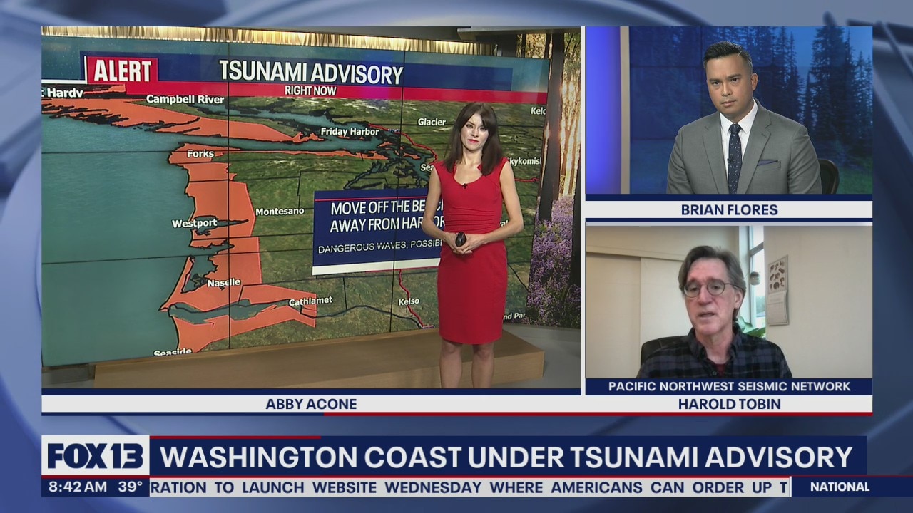
Expert breaks down tsunami advisory for US West Coast after Tonga eruption
A tsunami advisory was in effect for Hawaii, Alaska and the U.S. Pacific coast, with reports of waves pushing boats up in the docks in Hawaii. Harold Tobin, Director of the Pacific Northwest Seismic Network, joined FOX 13 Morning News to break down the alert.
A tsunami advisory was in effect for Hawaii, Alaska and the U.S. Pacific coast, with reports of waves pushing boats up in the docks in Hawaii. Harold Tobin, Director of the Pacific Northwest Seismic Network, joined FOX 13 Morning News to break down the alert.


Stevens Pass ski pass holders frustrated with new conditions
Skiers are back on the slopes at Stevens Pass Ski Area amid changes being made by its corporate owner to improve the customer experience.
Skiers are back on the slopes at Stevens Pass Ski Area amid changes being made by its corporate owner to improve the customer experience.
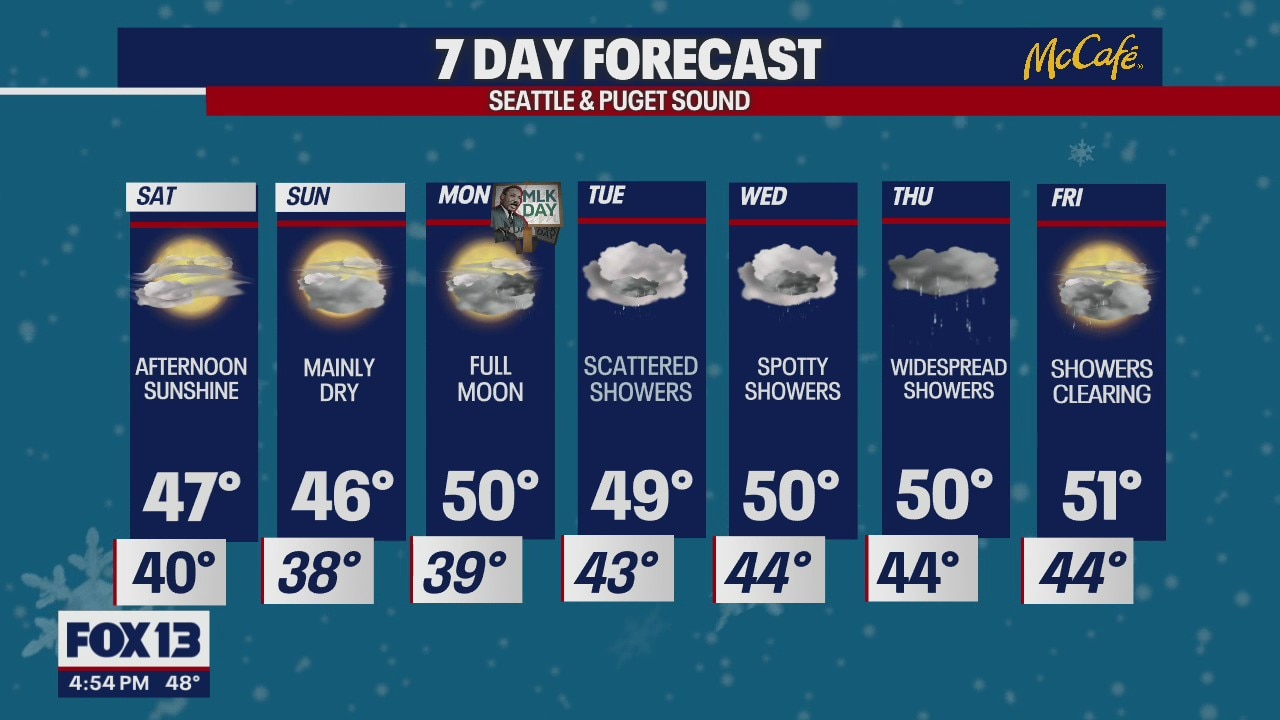
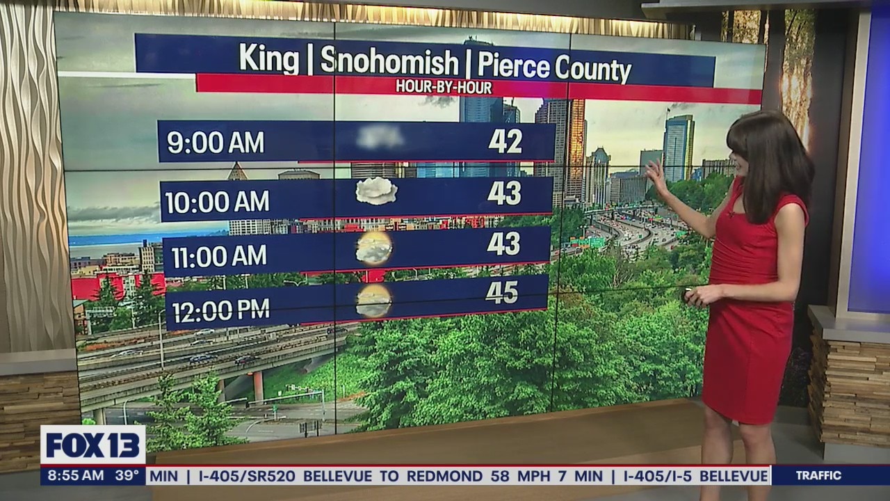
Mostly dry this weekend
FOX 13 Chief Meteorologist has the latest forecast on what you can expect this weekend
FOX 13 Chief Meteorologist has the latest forecast on what you can expect this weekend


The first dry stretch in months starts today
Areas of Western Washington woke up to patchy fog this morning, but a nice mix of clouds and sunshine is returning this afternoon with mainly dry weather expected the next three days.
Areas of Western Washington woke up to patchy fog this morning, but a nice mix of clouds and sunshine is returning this afternoon with mainly dry weather expected the next three days.
Dry stretch for the weekend before rain returns Monday
It's been since September that we have strung together three days without rain.
It's been since September that we have strung together three days without rain.


Mom, baby survive roof collapse after winter storm in Leavenworth
Snow operations are finally beginning to scale back in Leavenworth and this weekend will look fairly normal for visitors. However, for Emily Elkins this is just the beginning of trying to recover from the winter storm’s damage.
Snow operations are finally beginning to scale back in Leavenworth and this weekend will look fairly normal for visitors. However, for Emily Elkins this is just the beginning of trying to recover from the winter storm’s damage.


Patchy fog returns tonight
As the temperatures drop tonight - be on the lookout for fog. It'll be patchy, but dense. I'm already starting to see it develop across the mountain passes, foothills, and the South Sound.
As the temperatures drop tonight - be on the lookout for fog. It'll be patchy, but dense. I'm already starting to see it develop across the mountain passes, foothills, and the South Sound.


Here's how to report potholes in your area from the latest winter storm
With recent flooding and winter weather slamming western Washington, areas are now seeing roads impacted from the initial storms and cleanup.
With recent flooding and winter weather slamming western Washington, areas are now seeing roads impacted from the initial storms and cleanup.


Finally drying out as we sail into the weekend!
What a gorgeous close to Thursday! Temps running above average again landing in the mid to low 50 across Western WA.
What a gorgeous close to Thursday! Temps running above average again landing in the mid to low 50 across Western WA.