


DNR lands east of Cascades to reopen Thursday
Washington Department of Natural Resources lands east of the Cascades will reopen to public access on Thursday, after closing in July due to extreme heat, drought and wildfire risk.
Washington Department of Natural Resources lands east of the Cascades will reopen to public access on Thursday, after closing in July due to extreme heat, drought and wildfire risk.


Fires shut Sequoia National Park, could threaten huge trees
The massive sequoias grow on the western slope of the Sierra Nevada. The General Sherman Tree stands 275 feet and is over 36 feet in diameter at the base, according to the U.S. National Park Service.
The massive sequoias grow on the western slope of the Sierra Nevada. The General Sherman Tree stands 275 feet and is over 36 feet in diameter at the base, according to the U.S. National Park Service.
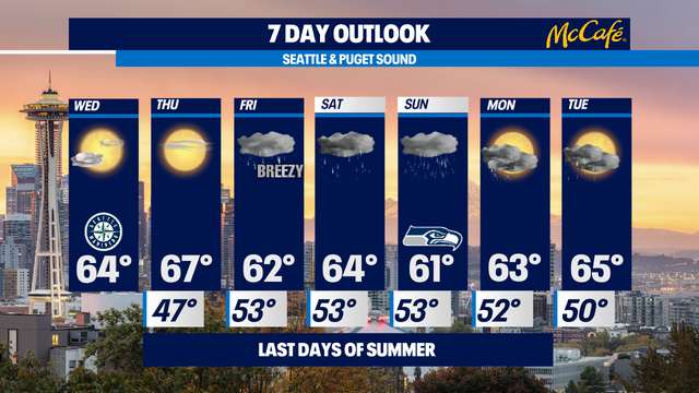

Last two sunny summer days before rain moves in
Our last weekend of summer will feature "rain at times" with highs below normal - low-to-mid 60s.
Our last weekend of summer will feature "rain at times" with highs below normal - low-to-mid 60s.

Last two sunny summer days before rain moves in
Q13 News Meteorologist M.J. McDermott says to enjoy the last two sunny days before rain moves in this weekend.
Q13 News Meteorologist M.J. McDermott says to enjoy the last two sunny days before rain moves in this weekend.


Nicholas downgraded to tropical depression, continuing to move slowly east into Louisiana
Nicholas has been downgraded to tropical depression as it continues crawling toward Louisiana after battering Southeast Texas with gusty winds and torrential rain.
Nicholas has been downgraded to tropical depression as it continues crawling toward Louisiana after battering Southeast Texas with gusty winds and torrential rain.

A chance for light showers tonight before we dry out mid-week with a stronger system delivering weekend rain.
A slightly cooler than average type of day for most of us around the region. We saw cooler temperatures north of Seattle and at the coast with warmer highs to the south, with SeaTac landing just a couple of degrees shy of normal.
A slightly cooler than average type of day for most of us around the region. We saw cooler temperatures north of Seattle and at the coast with warmer highs to the south, with SeaTac landing just a couple of degrees shy of normal.

Fall showers moving into Western Washington
Forecaster Erin Mayovsky is tracking fall-like showers across Western Washington.
Forecaster Erin Mayovsky is tracking fall-like showers across Western Washington.


Cooling off into the 60s with showers chances returning with steadier rain through the weekend.
Looking ahead to this evening…. futurecast models show rain from Seattle northward, but anyone could get a brief shower.
Looking ahead to this evening…. futurecast models show rain from Seattle northward, but anyone could get a brief shower.


Backwards bolt: Watch as lightning heads skyward from NYC's World Trade Center
A thunderstorm that rolled through New York City Monday night put on a dazzling display of lightning, including several bolts that struck the World Trade Center.
A thunderstorm that rolled through New York City Monday night put on a dazzling display of lightning, including several bolts that struck the World Trade Center.

Watch as lightning heads skyward from NYC's World Trade Center
A thunderstorm that rolled through New York City Monday night put on a dazzling display of lightning, including several bolts that struck the World Trade Center. Video: Christopher Scragg
A thunderstorm that rolled through New York City Monday night put on a dazzling display of lightning, including several bolts that struck the World Trade Center. Video: Christopher Scragg
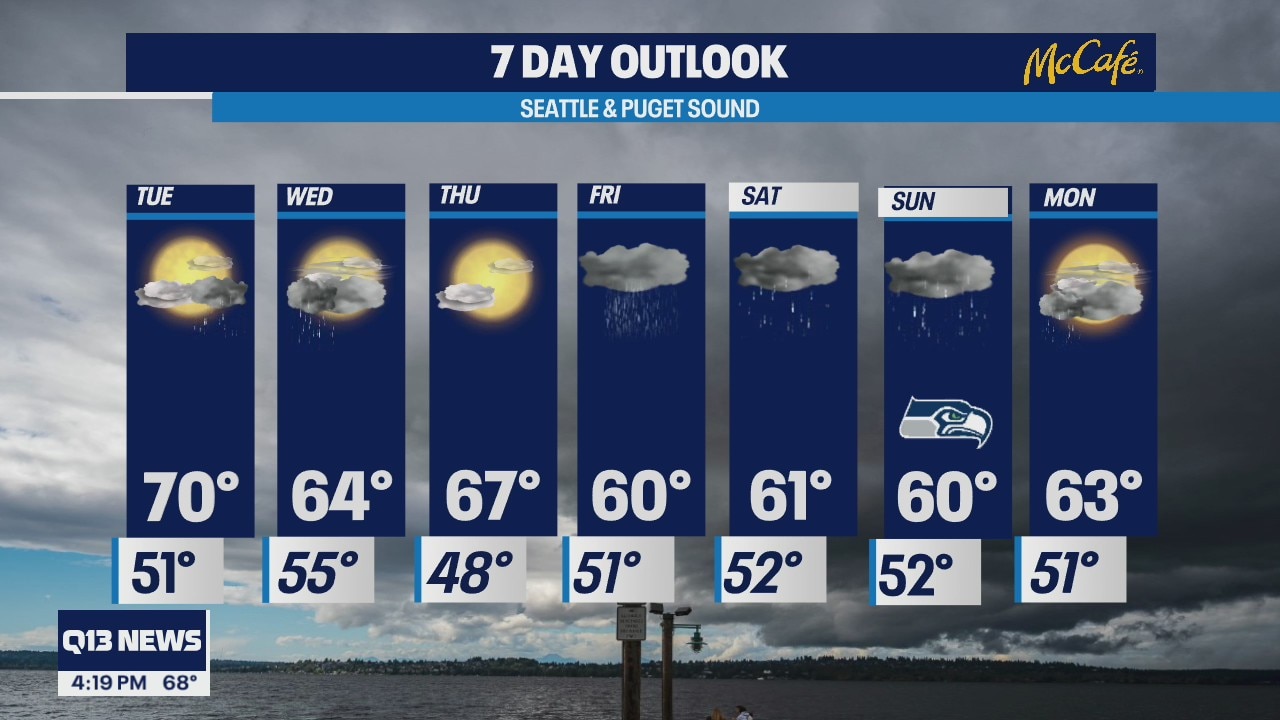
Temps in the low 70s across western Washington
Some areas could see rain
Some areas could see rain


Nicholas upgraded to hurricane as it heads for Texas Gulf Coast
The National Hurricane Center in Miami says Nicholas has strengthened to a Category 1 hurricane ahead of its expected landfall in Texas.
The National Hurricane Center in Miami says Nicholas has strengthened to a Category 1 hurricane ahead of its expected landfall in Texas.


Photographer captures bioluminescent glow in wake of Seattle ferry
A trip on a Washington State ferry treated a local photographer an amazing sight of bioluminescence in Puget Sound.
A trip on a Washington State ferry treated a local photographer an amazing sight of bioluminescence in Puget Sound.


Biden: Western wildfires ‘supercharged by climate change’
“Scientists have been warning us for years that extreme weather is going to get more extreme,” President Joe Biden said after touring wildfires in northern California.
“Scientists have been warning us for years that extreme weather is going to get more extreme,” President Joe Biden said after touring wildfires in northern California.
Rain headed for Western Washington this weekend
Meteorologist Mace Michaels says incoming rain will help firefighters
Meteorologist Mace Michaels says incoming rain will help firefighters


The plane truth: What made this spooky-looking cloud near Portland?
A rather surreal sight greeted visitors to the Vista House in the Columbia River Gorge on Sunday: A cloud formation that might be described as maybe a floating centipede, or some sort of feathery vortex?
A rather surreal sight greeted visitors to the Vista House in the Columbia River Gorge on Sunday: A cloud formation that might be described as maybe a floating centipede, or some sort of feathery vortex?


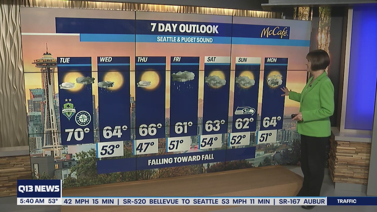
Falling toward Fall - cooling down and getting wet the last weekend of summer
Today will be pleasant. We're starting out with clouds, but the clouds will clear and this afternoon will be mostly sunny with highs below normal - upper 60s to near 70. 73 is normal for this time of the year.
Today will be pleasant. We're starting out with clouds, but the clouds will clear and this afternoon will be mostly sunny with highs below normal - upper 60s to near 70. 73 is normal for this time of the year.

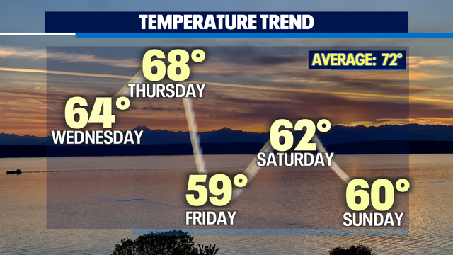
Rain and cooler temperatures on the way
Temperatures are cooling down as fall approaches. Meteorologist M.J. McDermott says rain is on the way.
Temperatures are cooling down as fall approaches. Meteorologist M.J. McDermott says rain is on the way.


Fall Has Arrived
Happy Sunday! Talk about a cool and damp weekend. Highs have been below average, and it looks like this trend will continue. Fall has arrived early :)
Happy Sunday! Talk about a cool and damp weekend. Highs have been below average, and it looks like this trend will continue. Fall has arrived early :)
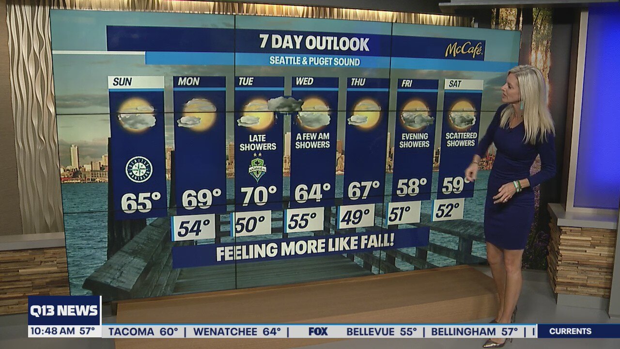
Cooler temps and feeling more like fall
Temperatures in the mid to upper 60s for the week
Temperatures in the mid to upper 60s for the week