Rain wraps up overnight with dry and cool conditions for the weekend!
Seattle - After an active couple of days we'll finally start to settle down tomorrow.
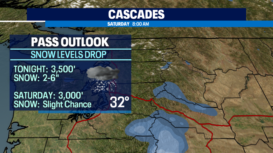
As a cold front continues to move through Western WA tonight we'll see showers over the South Sound and east over the Cascades. Pass travel could be a bit dicey overnight into tomorrow with snow levels near 3,000'. We expect a few more inches to fall, especially over US 2-Stevens Pass while a rain snow mix falls at Snoqualmie. Snow levels will continue to fall over the weekend and into the first part of the week, but we won't have much moisture to work. By Monday night into Tuesday snow will start to fall again over the mountains which be very helpful in building up our snow pack for area resorts.
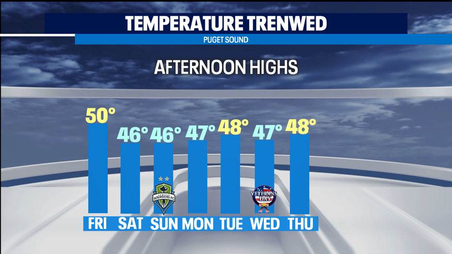
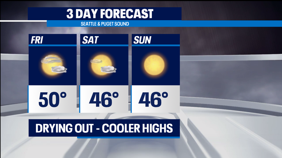
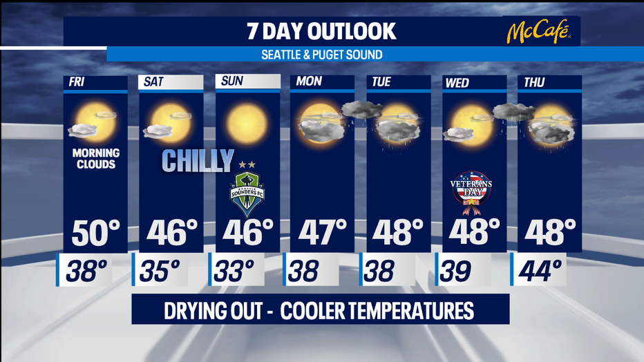
Back down in the lowlands.... a front will slide south into Oregon and any lingering showers will have wrapped up leaving us with a pretty nice Friday afternoon. Highs will sit near 50, just a few degrees shy of our seasonal average.
Saturday and Sunday both look really nice and cool with highs only reaching the mid to upper 40s. Brr! This all thanks to a shift in winds to a northerly flow which will keep us chilly and dry into the start of the work week. Saturday there is a slight chance of a few showers to the south, otherwise we'll see partly to mostly sunny skies. Sunday skies will be very clear. Overnights dip into the low 30s. Valley areas could see temperatures fall below freezing into the upper 20s.
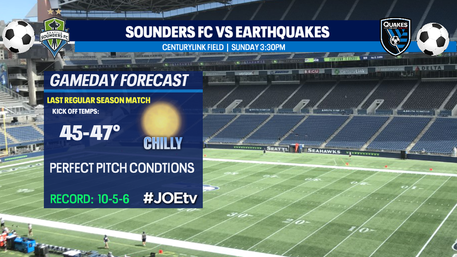
Don't forget to check out the Sounders FC last regular season match Sunday afternoon. Kick off against the San Jose Earthquakes set for 3:30pm at CenturyLink Field. You can catch all the game action on #JOEtv.
Another chilly start Monday with dry weather hanging on, but by the afternoon clouds will increase as a system starts to move in from offshore. The front moves through Monday into Tuesday delivering lowland showers with light mountain snow. Highs remain below normal, only in the mid 40s. Lows will warm up a touch into the upper 30s to near 40.
At this point drier conditions look possible for Veterans Day with highs in the upper 40s.
An active weather pattern heads our way again towards the end of the week pushing in several systems dropping rain across the region with mountain snow.
Have a great night! ~Erin
______________________________________________
- Erin Mayovsky, Q13 Forecaster
Twitter: @ErinMayovsky
FaceBook: /ErinMayovsky
Instagram: @ErinMayovsky
______________________________________________