


Drying out and warmer up as Summer arrives early Tuesday!
We did it! Temperatures warming into the low 60s around the region Saturday. Seattle ending the day at 63, that's up six degrees over Friday's cool high of 57.
We did it! Temperatures warming into the low 60s around the region Saturday. Seattle ending the day at 63, that's up six degrees over Friday's cool high of 57.


Chilly weekend ahead with the 70s back by Tuesday
While the “June gloom” hangs on this weekend, the 70s are finally returning to Seattle by Tuesday.
While the “June gloom” hangs on this weekend, the 70s are finally returning to Seattle by Tuesday.

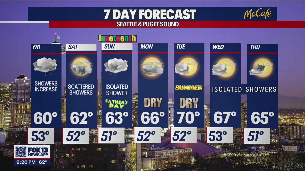
Wet and rainy in Seattle this weekend, but things finally start to get drier next week
Wet and rainy in Seattle this weekend, but things finally start to get drier next week
Wet and rainy in Seattle this weekend, but things finally start to get drier next week


Denver man rescued by helicopter after being stranded by Yellowstone floodwaters
Jacob Showers and his girlfriend were trail-running in the backcountry when the area began to flood and wash away.
Jacob Showers and his girlfriend were trail-running in the backcountry when the area began to flood and wash away.


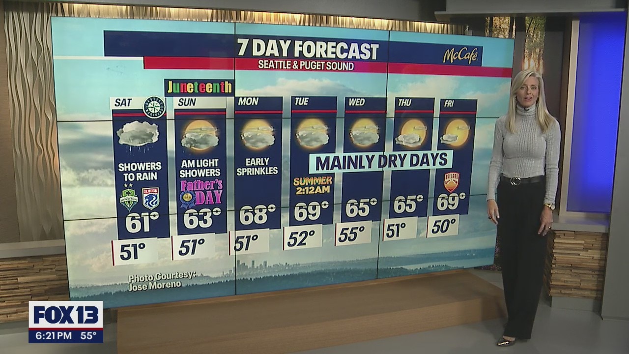
Cool and showery weekend on tap as we celebrate Father's Day
As we dissect the weekend, Saturday looks a little wetter and cooler than Sunday. Skies will remain cloudy both days, but Father's Day only sees a few showers very early, otherwise mostly dry. Highs hang well below average in the upper 50s to low 60s.
As we dissect the weekend, Saturday looks a little wetter and cooler than Sunday. Skies will remain cloudy both days, but Father's Day only sees a few showers very early, otherwise mostly dry. Highs hang well below average in the upper 50s to low 60s.
Showers expected all weekend
Father's Day will see some light morning showers with temps in the low 60s
Father's Day will see some light morning showers with temps in the low 60s


Gloomy Father's Day weekend ahead
Hope you don't mind the gloomy skies – this weekend is looking very gray and chilly.
Hope you don't mind the gloomy skies – this weekend is looking very gray and chilly.

Showers and cooler temperatures for the weekend
We'll start to dry out by next week as high pressure makes a brief come back! Expect more sunshine and warmer temperatures.
We'll start to dry out by next week as high pressure makes a brief come back! Expect more sunshine and warmer temperatures.


Cloudy skies, showers and cooler temperatures tomorrow
We're getting ready for the temperatures to drop, clouds to build, and the showers to increase! A new system will cause the changes beginning tomorrow morning. You'll notice the showers increasing throughout the day.
We're getting ready for the temperatures to drop, clouds to build, and the showers to increase! A new system will cause the changes beginning tomorrow morning. You'll notice the showers increasing throughout the day.
Cooler next few days with showers
FOX 13 chief meteorologist Lisa Villegas has the latest forecast
FOX 13 chief meteorologist Lisa Villegas has the latest forecast


No days in the 70s for Western Washington in the seven-day forecast
There's still no major warmup on the short-term horizon for Western Washington. Highs all week will only reach the 60s!
There's still no major warmup on the short-term horizon for Western Washington. Highs all week will only reach the 60s!


Just chillin': Town in Arctic Circle has had warmer days than Seattle this year
Seattle's maximum temperature of 73 degrees so far in 2022 is a record for the coldest high temperature through June 15, and is cooler than some towns much farther north!
Seattle's maximum temperature of 73 degrees so far in 2022 is a record for the coldest high temperature through June 15, and is cooler than some towns much farther north!


Scope of catastrophic damage along Yellowstone River emerges as historic floodwaters recede
Montana National Guard says troops have rescued 87 people from floodwaters.
Montana National Guard says troops have rescued 87 people from floodwaters.

Showers and sunbreaks for Thursday in Seattle
We certainly are under a cool trend spell so far this year. Normally by this point in the season, we'd experience more 70-degree days, but so far this year, we've only seen seven days in the 70s. Usually, the month of May averages seven of those days with double that amount for June.?
We certainly are under a cool trend spell so far this year. Normally by this point in the season, we'd experience more 70-degree days, but so far this year, we've only seen seven days in the 70s. Usually, the month of May averages seven of those days with double that amount for June.?


Seattle weather: Warmer and drier Thursday with showers into the weekend
Overnight, look for spotty showers with temps falling off into the low 50s for the metro area.
Overnight, look for spotty showers with temps falling off into the low 50s for the metro area.


Report: Fires, heat waves cause ‘climate anxiety’ in youth
Oregon health officials say the impacts of climate change, including more devastating wildfires, heat waves, drought and poor air quality, are fueling "climate anxiety" among young people.
Oregon health officials say the impacts of climate change, including more devastating wildfires, heat waves, drought and poor air quality, are fueling "climate anxiety" among young people.


Cloudy and warmer for Wednesday, showers late
Western Washington will stay dry but mostly cloudy Wednesday, with light showers arriving later this evening.
Western Washington will stay dry but mostly cloudy Wednesday, with light showers arriving later this evening.

Mostly cloudy, showers expected around Seattle
Gaining daylight, sunset tonight to be 9:08 PM. Rain coming will dampen down pollen, and mild temperatures take over Washington Summer.
Gaining daylight, sunset tonight to be 9:08 PM. Rain coming will dampen down pollen, and mild temperatures take over Washington Summer.


Yellowstone National Park: Floods leave landscape 'dramatically changed'
Park officials say over 10,000 visitors left the nation’s oldest national park after historic flooding tore through the area, washing out bridges and roads.
Park officials say over 10,000 visitors left the nation’s oldest national park after historic flooding tore through the area, washing out bridges and roads.


Seattle weather: Temps warming up with just a few passing showers to end the work week
We'll continue the trend of warming up along with seeing less shower activity as high pressure builds. This will help keep stronger systems out of the Northwest, although we can't rule out a few light showers moving through late Wednesday through Thursday.
We'll continue the trend of warming up along with seeing less shower activity as high pressure builds. This will help keep stronger systems out of the Northwest, although we can't rule out a few light showers moving through late Wednesday through Thursday.