

Next wet system arrives late Wednesday night
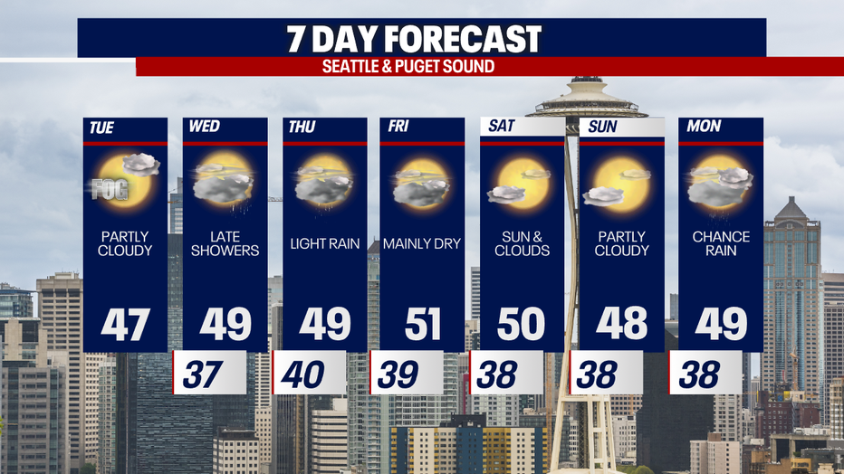
Seattle - Dry weather will continue through Wednesday with some sunshine in the mix today for Western Washington.
An upper level ridge of high pressure has shifted over the Pacific Northwest. Most areas are breaking through the clouds this Tuesday afternoon. We will continue to see decreasing clouds heading into sunset.

The next round of rain hits late Wednesday night into early Thursday as a frontal system pushes through the Pacific Northwest. This will bring rain showers through the Thursday morning commute. Snow levels will be around 4,000 feet, which means Stevens Pass is in luck for a few inches of new snow. However Snoqualmie and White passes won't see much, if anything.

Looking ahead, we will have very calm weather late this week and into next weekend. Temps will stay slightly above average with no big storms on the horizon.
If you're dreaming of a White Christmas this year, it's not looking good. White Christmases are very rare in Western Washington. The last time we had an inch on the ground on December 25 was 2017. You have to go way back to 1965 and 1909 for our last White Christmases in Seattle.

The Climate Prediction Center is forecasting warmer than usual temperatures for Christmas week this year. There will be plenty of spots around the country without a White Christmas.

Other than California and the greater southwest, we will be looking at average to drier than average rainfall during that week across the USA. The Pacific Northwest will be seeing close to average rainfall.
