

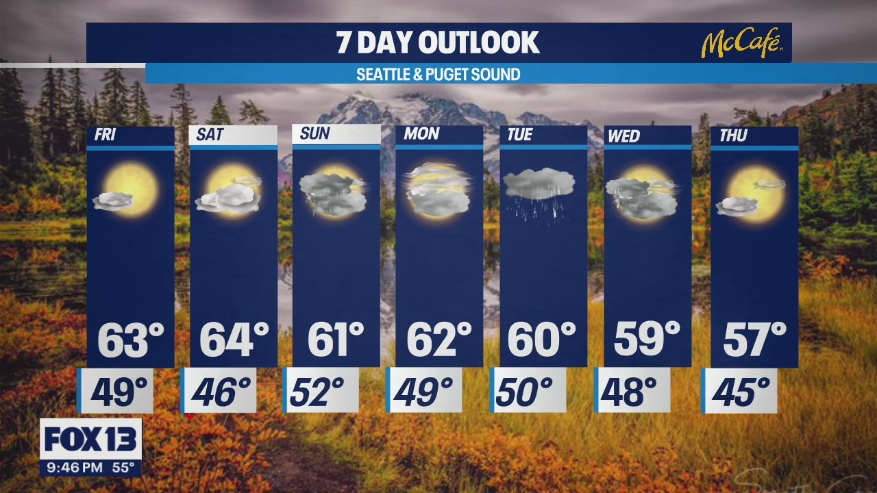
Cool temps for the next week
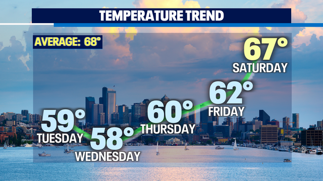
Highs will be in the low 60s and upper 50s
Highs will be in the low 60s and upper 50s


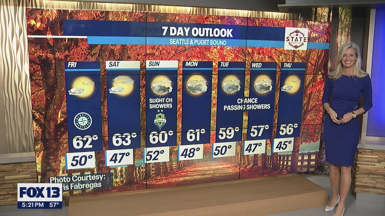
Brighter days ahead as showers decrease overnight with drier conditions over the weekend.
Happy Wednesday! A cool Fall day as yesterday's storm is on its way out! Highs only landing again in the upper 50s to low 60s.
Happy Wednesday! A cool Fall day as yesterday's storm is on its way out! Highs only landing again in the upper 50s to low 60s.
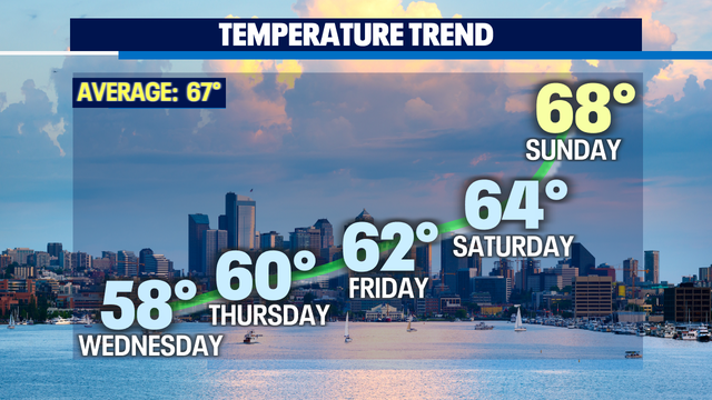
Temperatures feeling more fall-like next week
Highs will be in the low 60s and upper 50s
Highs will be in the low 60s and upper 50s


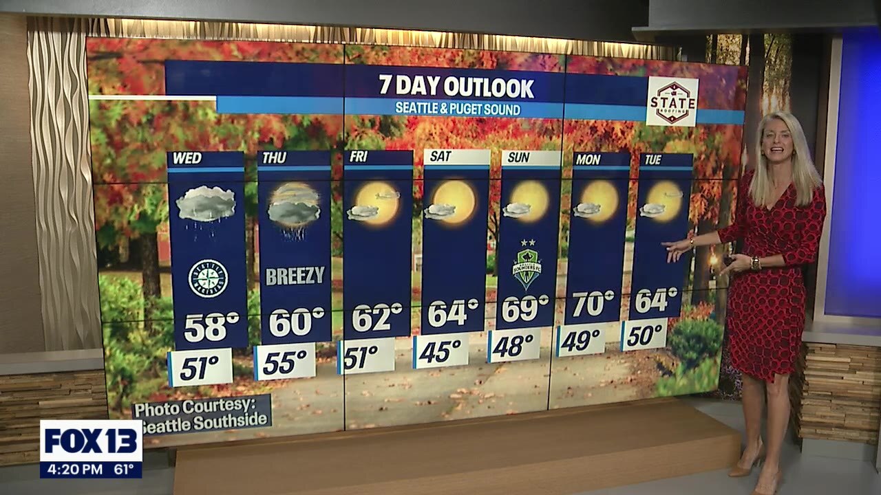
Sloppy end to September; sweet start to October
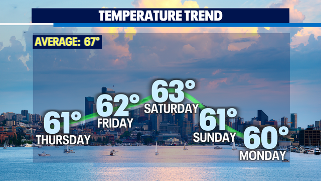
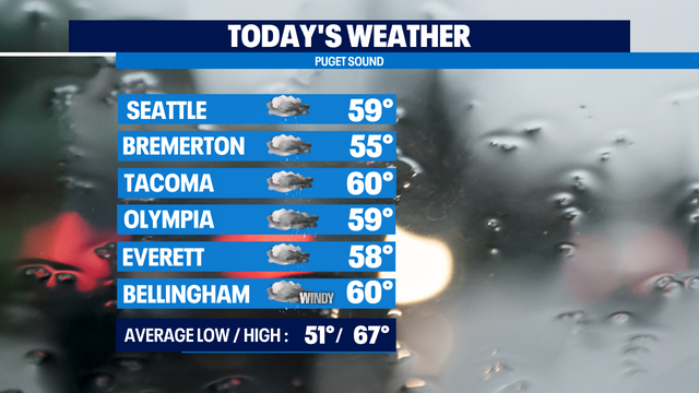
A potent rain band will drop some heavy rain on I-5 around lunchtime today, then we'll start to dry out. It is still pretty windy to the north with thousands of power outages in Whatcom County this morning, but the winds are calming down, and the Wind Advisory has been lifted. Highs today will be below normal, low 60s. The normal high for today is 67 degrees.
A potent rain band will drop some heavy rain on I-5 around lunchtime today, then we'll start to dry out. It is still pretty windy to the north with thousands of power outages in Whatcom County this morning, but the winds are calming down, and the Wind Advisory has been lifted. Highs today will be below normal, low 60s. The normal high for today is 67 degrees.

Rain to end September, sunshine to start October
There?ll be rain at times as September ends and it?ll be mostly sunny on Friday.
There?ll be rain at times as September ends and it?ll be mostly sunny on Friday.

Wet & windy conditions as a strong Fall storm delivers widespread rain and wind.
Cool and showery conditions across the region today. Highs Wednesday well below normal only landing in the upper 50s to low 60s around the region.
Cool and showery conditions across the region today. Highs Wednesday well below normal only landing in the upper 50s to low 60s around the region.
Enjoy the moderate weather while it lasts!
FOX 13 Forecaster Erin Mayovsky is tracking strong winds and scattered showers off and on through the week, but we're still in the 60s for the time being!
FOX 13 Forecaster Erin Mayovsky is tracking strong winds and scattered showers off and on through the week, but we're still in the 60s for the time being!


Therapy dogs comfort California crews battling wildfires
California firefighters were recently visited by therapy dogs who offered comfort and support as crews continue to battle multiple wildfires in the state.
California firefighters were recently visited by therapy dogs who offered comfort and support as crews continue to battle multiple wildfires in the state.


Schneider Springs Fire burning in Okanogan-Wenatchee National Forest now 55% contained
The Schneider Springs Fire, which has burned 107,118 acres of the Okanogan-Wenatchee National Forest, is now 55% contained.
The Schneider Springs Fire, which has burned 107,118 acres of the Okanogan-Wenatchee National Forest, is now 55% contained.

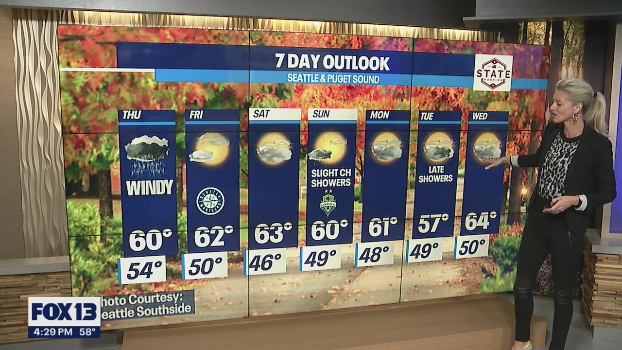
Wet & windy end to September
Rain is moving onto the Olympic Peninsula this morning and will move over I-5 this afternoon and evening. It'll be windy in places. The National Weather Service has issued a Wind Advisory for Western Whatcom County, the San Juans, Whidbey and Camano Islands, the Admiralty Inlet area and the North Coast. Gusts of up to 50 mph are possible, which could cause some power outages. It'll be a chilly day as well with highs only in the upper 50s to around 60. Normal for Seattle is now 67.
Rain is moving onto the Olympic Peninsula this morning and will move over I-5 this afternoon and evening. It'll be windy in places. The National Weather Service has issued a Wind Advisory for Western Whatcom County, the San Juans, Whidbey and Camano Islands, the Admiralty Inlet area and the North Coast. Gusts of up to 50 mph are possible, which could cause some power outages. It'll be a chilly day as well with highs only in the upper 50s to around 60. Normal for Seattle is now 67.

September ends with wet, windy conditions
The region will get a heavy band of rain moving in, and at the end of the week we'll dry up and see some sunshine.
The region will get a heavy band of rain moving in, and at the end of the week we'll dry up and see some sunshine.

A brief break before the next weather system marches towards WA delivering another round of rain and wind!
Happy Tuesday! Certainly, feels like Fall with our showery skies and cooler temperatures. Highs today only finding their way into the upper 50s to low 60s again.
Happy Tuesday! Certainly, feels like Fall with our showery skies and cooler temperatures. Highs today only finding their way into the upper 50s to low 60s again.


National Weather Service confirms EF-0 tornado hit near Battle Ground, Washington
The National Weather Service in Portland, Oregon, says Doppler radar and multiple videos indicated a weak tornado touched down north of Battle Ground, Washington.
The National Weather Service in Portland, Oregon, says Doppler radar and multiple videos indicated a weak tornado touched down north of Battle Ground, Washington.
Warmer, cozy fall temperatures to cap off our week!
Fall is here, but don't let the crazy winds and rains of the past week fool you?FOX 13 Forecaster Erin Mayovsky is tracking some downright pleasant weather for the rest of the week!
Fall is here, but don't let the crazy winds and rains of the past week fool you?FOX 13 Forecaster Erin Mayovsky is tracking some downright pleasant weather for the rest of the week!

Tornado caught on camera in Washington state
A tornado touched down in Battle Ground, Washington, on September 27 amid stormy weather in the region. (Credit: Tyler Mode via Storyful)
A tornado touched down in Battle Ground, Washington, on September 27 amid stormy weather in the region. (Credit: Tyler Mode via Storyful)
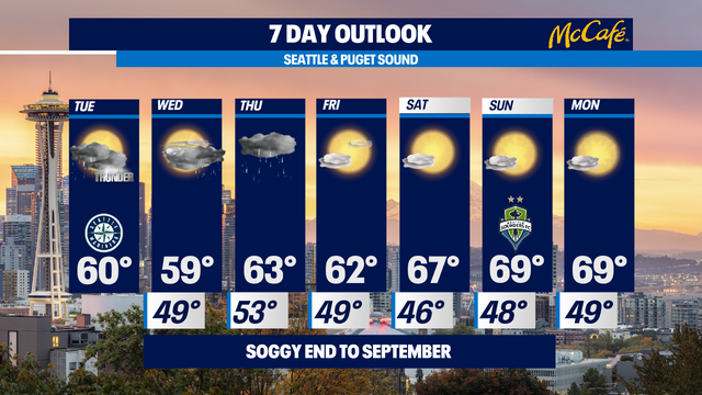

Soggy end to September
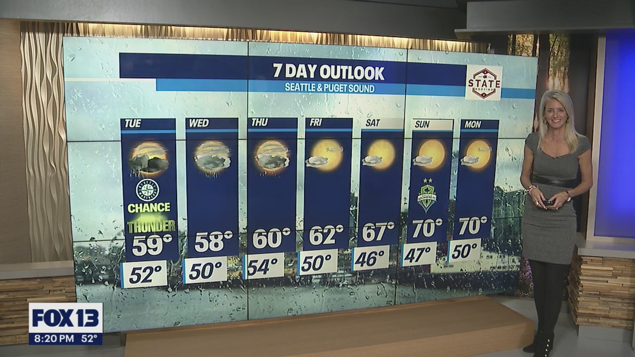
Today will be a lot like yesterday with showers and sun breaks and a slight chance of a thunderstorm. It will also be cooler than normal with highs trying to hit 60. Normal for today is 68.
Today will be a lot like yesterday with showers and sun breaks and a slight chance of a thunderstorm. It will also be cooler than normal with highs trying to hit 60. Normal for today is 68.

Tornado touches down in southern Washington state
A tornado touched down in Battle Ground, Washington, on September 27 amid stormy weather in the region. The National Weather Service (NWS) confirmed the tornado, describing it as ?weak?. (Credit: Tyler Mode via Storyful)
A tornado touched down in Battle Ground, Washington, on September 27 amid stormy weather in the region. The National Weather Service (NWS) confirmed the tornado, describing it as ?weak?. (Credit: Tyler Mode via Storyful)

Showers, some sun breaks and chance of isolated thunderstorms
On Tuesday, the region will get rain, some sun breaks and a chance of an isolated thunderstorm.
On Tuesday, the region will get rain, some sun breaks and a chance of an isolated thunderstorm.
Temps in the high 50s, low 60s this week
It's feeling a little more like fall in Puget Sound!
It's feeling a little more like fall in Puget Sound!

Stormy Fall weather continues as we roll into the work week with brighter skies into the weekend!
Rain picks up throughout the day, especially for the North Sound where the threat of thunderstorms looms again.
Rain picks up throughout the day, especially for the North Sound where the threat of thunderstorms looms again.