

Historic, record-breaking heat across the Pacific Northwest will continue through Tuesday

All-time record setting heat Monday in Western Washington
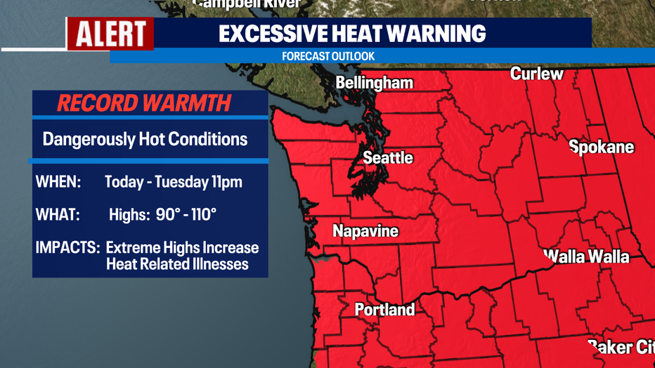
Q13 News Meteorologist M.J. McDermott is tracking an excessive heat warning through Tuesday.
SEATTLE - What a day for the record books! Day two of our historic heat wave set new all-time high temperatures records.
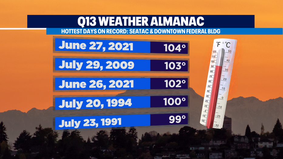
Many of our locations across Western Washington jumped into the triple digits on Sunday. We hit 104 at Sea-Tac Airport, smashing yesterday's 102 high and the all-time high of 103 set back on July 29, 2009.
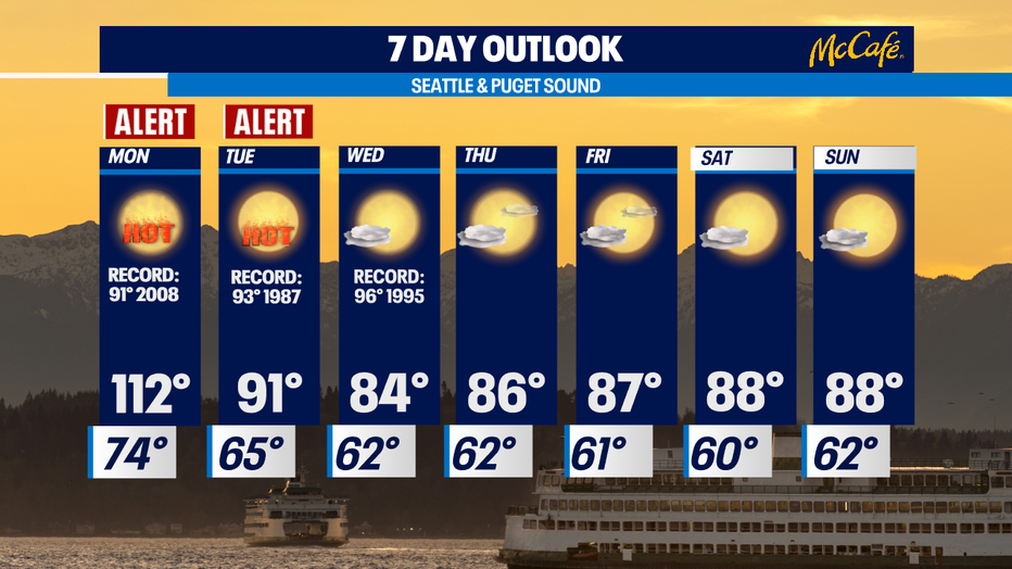
And the mercury won't quit rising as high pressures continues to strengthen. We'll see temperatures soaring above 104 and landing at 110+ for Monday!
Please stay hydrated and do the best you can to stay cool. Don't forget to check on loved ones, especially those who suffer heat-related illnesses. And keep those furry friends cool by wetting them down and off the extremely hot asphalt and concrete!
RELATED: Tips for pet owners ahead of Washington's heat wave
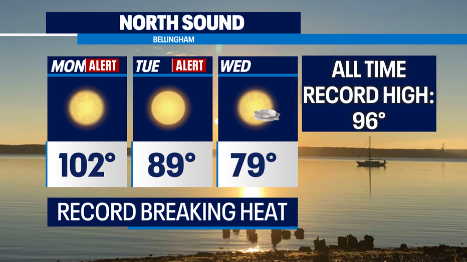
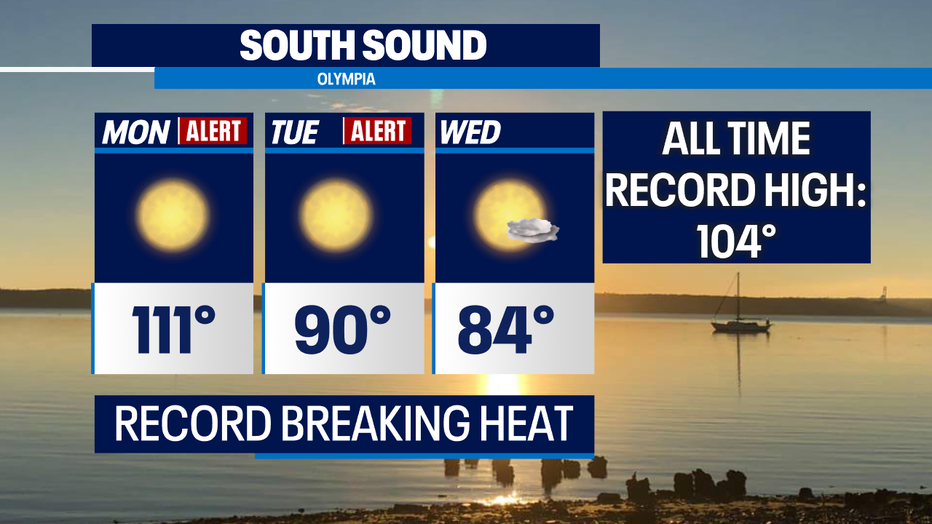
Our "Excessive Heat Warning" is being extended through Tuesday at 11 pm. Monday will be dangerously hot with highs around 101 in the North Sound, 110+ in the Central Sound, and 114 in the South Sound. Downslope winds will make Eastside areas like Issaquah, Bellevue and Sammamish even hotter around 115+!
RELATED: What makes this heat wave so unusual?
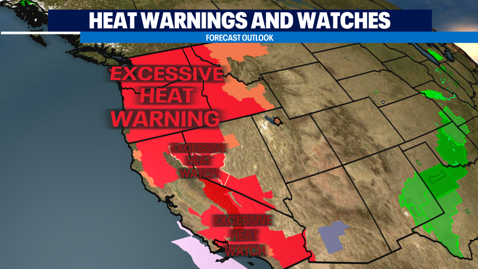
Not only are we setting records in Washington, but many areas around the Northwest and farther south are under extreme heat watches or warnings. More than 33 million people covering a span of seven states have emergency heat alerts stretching as far south as Southern California. Some cities are seeing temperatures soar some 30+ degrees above normal!
With this kind of heat we want to remind you the extreme temperatures are the No. 1 cause of weather related deaths.
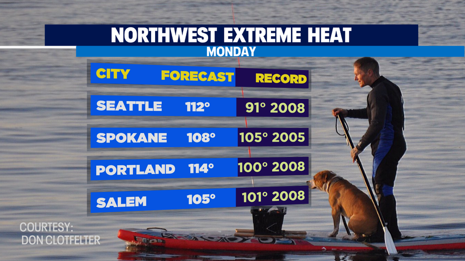
Monday's forecast for select cities around the Northwest:
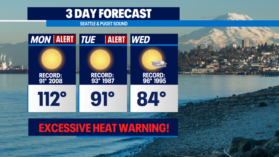
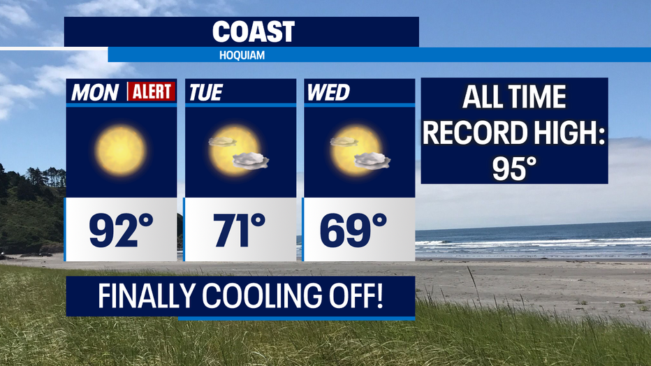
Here's a look at the next three days. Cooler marine air will start at the coast tomorrow while inland temperatures around Puget Sound will soar into historic record territory again and then start cooling Tuesday into Wednesday!
*Central Sound
*North Sound
*South Sound
*Coast
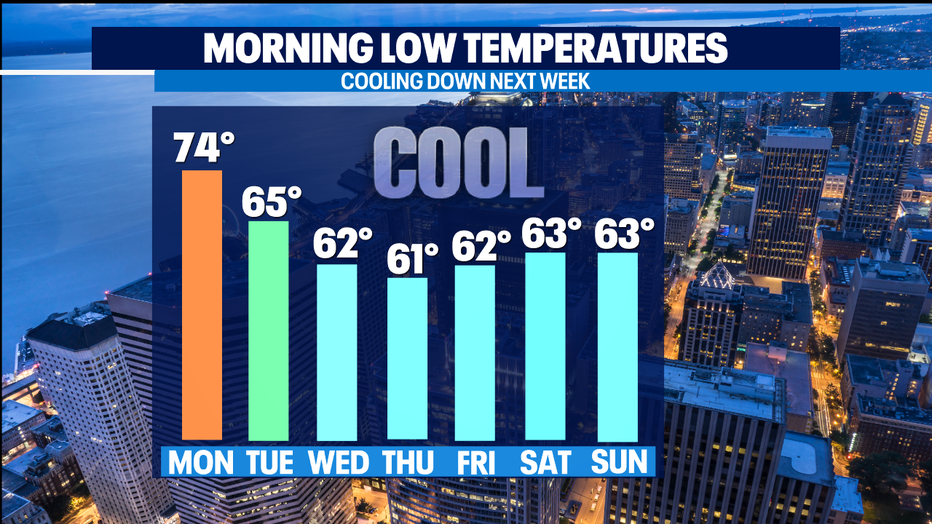
We'll finally "cool" down by Tuesday but it will still be warm around 91, which is just two degrees below the previous record at Sea-Tac of 93. At least overnight lows will be back down into the lower 60s, helping to cool our homes. Highs will be in the mid to upper 80s as we round out the work week and head into the weekend.
Stay safe all! We will get through this historic event! ~Erin Mayovsky, Q13 Forecaster
*Hottest Days on Record: SeaTac & Downtown Federal Building
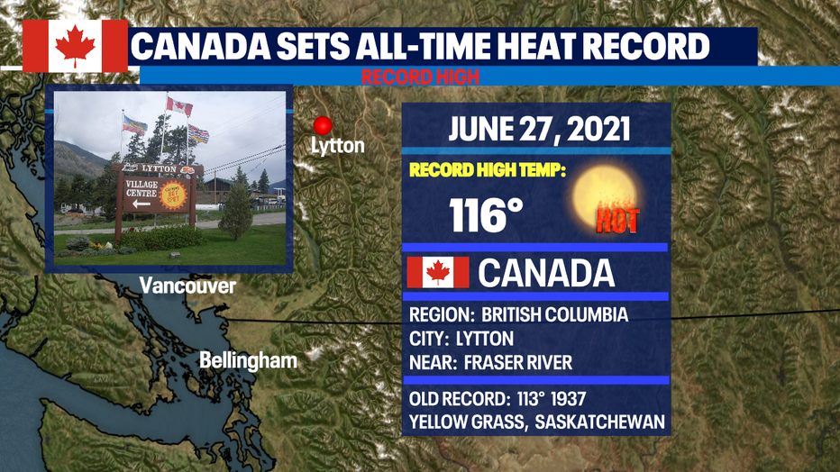
*Hottest Day ever for Canada

Q13 FOX WEATHER RESOURCES:
DOWNLOAD: Q13 Weather and News Apps
WATCH: Forecast and Radar
READ: Closures and Delays
CHECK: Latest Weather Alerts and Live Traffic Map
INTERACT: Submit your Weather Photo
FOLLOW: Lisa Villegas, MJ McDermott, Erin Mayovsky, Grace Lim and Scott Sistek