

Snow creates slick conditions for parts of Western Washington
Will it snow? Tracking cold weather and snow near Seattle and Puget Sound
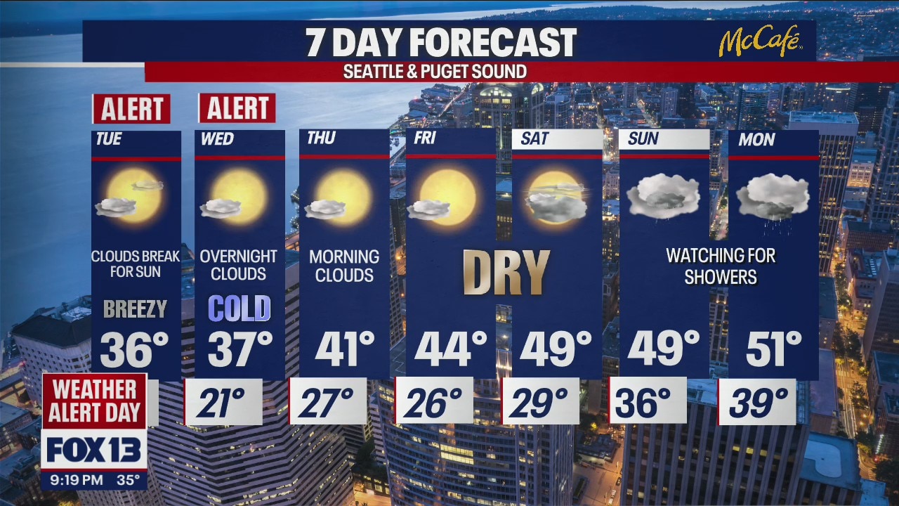
FOX 13 has issued a Weather Alert Day as temperatures drop into the 20s overnight and won't go above 40 degrees. Snow is expected in some areas.
SEATTLE - It's a Weather Alert Day. The temperatures are dropping, the winds are whipping, and the snow is falling. Be on the lookout for icy and slick spots tonight and tomorrow morning as the light coating of snow freezes over.
This shot was taken outside of Maple Valley earlier this evening:

A Winter Weather Advisory is in effect until 1 a.m. We'll continue to watch out for fat wet flakes and snow totals ranging between 1-3".
Use caution on the roadways Wednesday morning as temperatures drop into the 20s. This will make for slick and icy spots across Western Washington.

On top of the snow and slick spots, we'll have to bundle up! The winds continue to whip out there, and wind advisories will remain in effect until tomorrow for the following locations:


Take the temperatures and factor in the wind speeds - we get the wind chills (Feels-like temperatures)! Wind chills will drop into the teens and single digits for some of us as winds continue to flow from the NE.

No doubt will it be cold tomorrow morning but at least the sun will pop back out! Even with the help of the sun, it'll continue to be very cold in the afternoon. Highs will only peak in the 30s for most of us. Those strong wind speeds will be spilling that cold air into Western Washington.
Here is a look at your afternoon highs:


A Weather Alert Day will be in place tomorrow morning along with Wednesday morning due to the cold and icy conditions. Use caution out there and take it easy!

MORE FROM FOX 13 WEATHER:
DOWNLOAD: FOX 13 Weather and News Apps
WATCH: Forecast and Radar
READ: Closures and Delays
CHECK: Latest Weather Alerts and Live Traffic Map
INTERACT: Submit your Weather Photo
DAILY BRIEF: Sign Up For Our Newsletter
FOLLOW: Lisa Villegas, Erin Mayovsky, Brian MacMillan, Abby Acone and Scott Sistek