

More snow ahead Wednesday night into Thursday for Seattle

Seattle weather: Snow shower mix for Wednesday
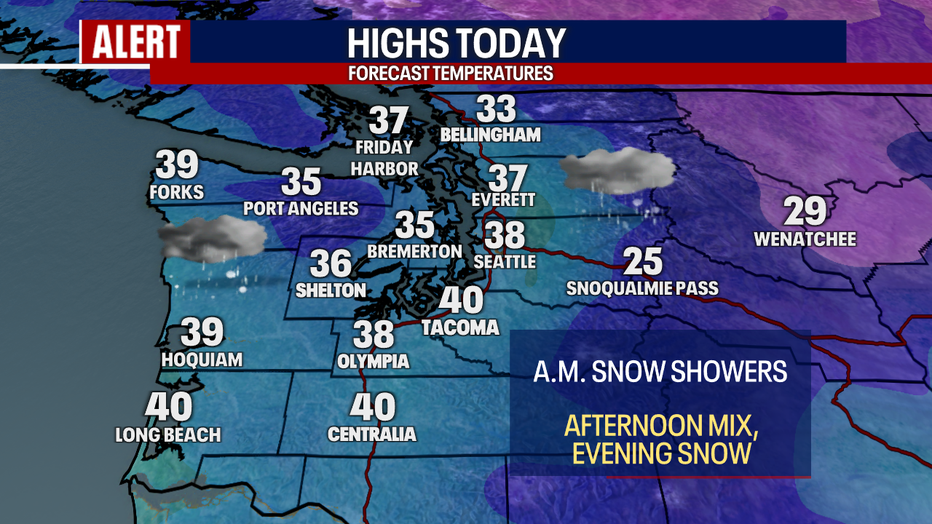
Snow showers are expected for Wednesday in Western Washington.
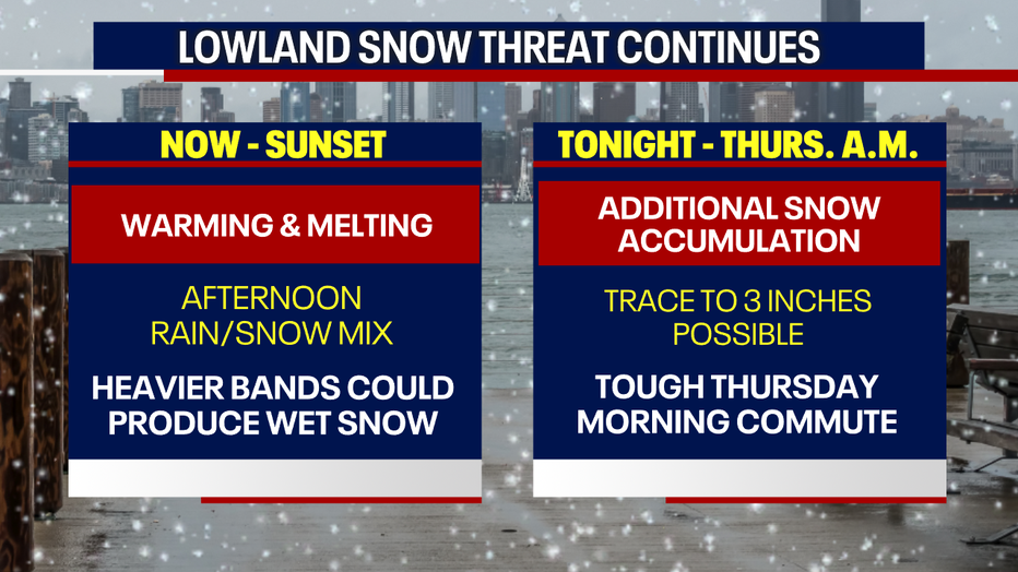
SEATTLE - On the heels of a snowy Wednesday morning commute for many in King and Snohomish counties, another round of lowland snow is in the forecast for early Thursday morning.
A low pressure system parked offshore will continue to spin showers into the greater Puget Sound area on Wednesday afternoon and evening.
Here’s a breakdown of what is next:
Rain-snow mix in Seattle this week
Local perspective:
Warming temperatures will bring a rain and snow mix and promote melting through the daylight hours. Heavier showers could produce brief rounds of wet snow, but most spots will just see a mix today.
It will be cool with rounds of rain/snow mixed showers Wednesday in Western Washington. (FOX 13 Seattle)
Later this week
What we know:
The next chance for lowland snow will arrive after dinnertime Wednesday evening as temperatures fall and rounds of showers continue to push into the Puget Sound area. The showery nature of this precipitation makes it tough to pinpoint exactly where the heaviest snow will fall, but this round of snow has a potential of impacting more areas.
A trace to three inches is possible in most lowland locations from Arlington to Chehalis. There will be spots that get close to nothing and other areas could achieve more than three inches. The biggest factors will be how fast it gets cold and how long precipitation lasts tonight.
More snow is expected Wednesday night into Thursday morning. (FOX 13 Seattle)
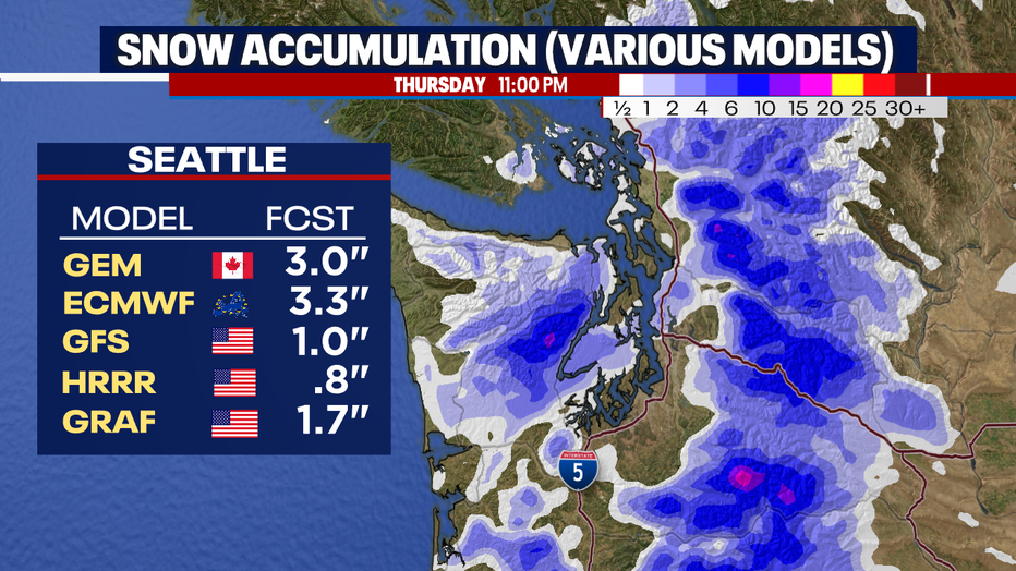
One to three inches of snow is possible in the Puget Sound area by Thursday morning. (FOX 13 Seattle)
We should dry out by the second half of the morning commute, with sunshine on tap for the second half of the day. Temperatures will warm again to the mid 30s, which should help melt any snow or ice on the main roads by midday.
Showers and a chance of snow this weekend
What's next:
Friday looks dry and partly cloudy, but still cool.
There is a chance of some light showers this weekend. I can’t completely rule out overnight light snow this weekend, but it won’t amount to much.
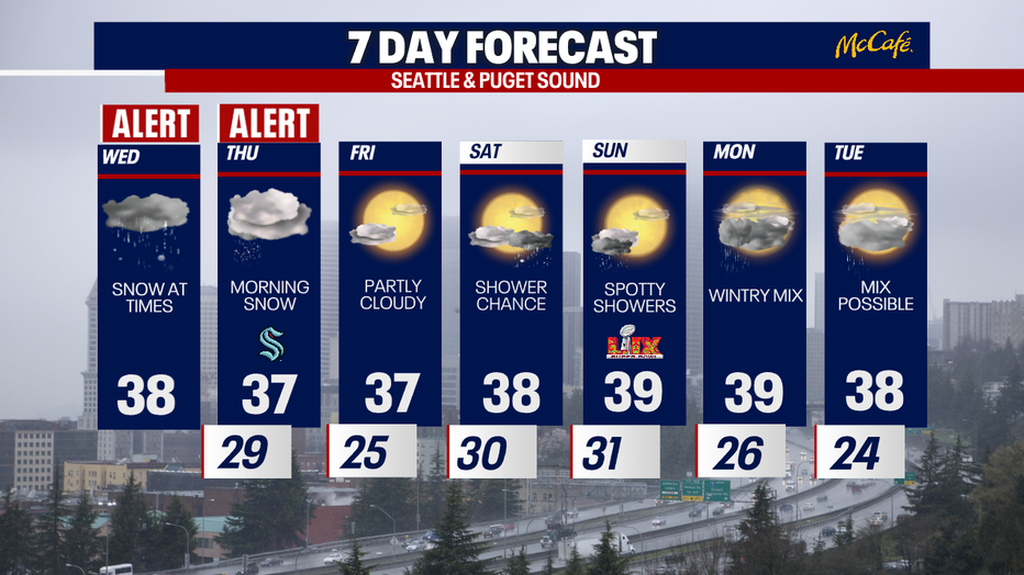
Thursday will bring another chance of morning snow to the greater Puget Sound area. (FOX 13 Seattle)
Frigid Fraser Valley outflow winds will ease up a big this afternoon, but temperatures will remain frigid in Western Whatcom County with light snow expected overnight.
The Washington Coast will see fewer showers than inland locations later tonight. The best chance for snow will remain around the Puget Sound area.
Central Washington will be very chilly today with highs in the 20s and on and off snow showers.
The Source: Information comes from weather models analyzed by FOX 13 Seattle Chief Meteorologist Brian MacMillan.
More top headlines from FOX 13 Seattle
Seattle mom beats 14-year-old son to death, causing over 1K wounds: docs
Seattle high school principal on leave after DUI, reckless endangerment arrest
First electric fire truck in WA unveiled in Redmond
King County Metro purchase of 120 Teslas faces scrutiny as anti-Tesla sentiment in WA grows
Could new tariffs cost Washington State $4.1B? What we know
To get the best local news, weather and sports in Seattle for free, sign up for the daily Fox Seattle Newsletter.
Download the free FOX LOCAL app for mobile in the Apple App Store or Google Play Store for live Seattle news, top stories, weather updates and more local and national coverage, plus 24/7 streaming coverage from across the nation.