

Powerful 'bomb cyclone' brings mountain blizzards, power outages to Pacific Northwest

Seattle weather: Blizzard warning in Cascades, rain and wind in lowlands
FOX 13 Chief Meteorologist Brian MacMillan has a look at your forecast.
SEATTLE - A powerful "bomb cyclone" is blasting the Pacific Northwest Tuesday morning, knocking out power with ferocious winds and bringing rare blizzard conditions to the Cascades and Olympics.
Over 100,000 people lost power across western Washington and Oregon during the peak of the storm early Tuesday morning as wind gusts reached 40-60 mph.
High Wind Warnings and Wind Advisories remain in effect through late Tuesday evening for continued gusts to 50-60 mph in parts of the interior and 65-mph gusts along the coast.

Washington power outages: Tens of thousands lose power as storm moves through Pacific Northwest
Tens of thousands of people were without power Tuesday as rain, snow and gusty winds hit the greater Seattle area.
Meanwhile, blizzard conditions are pummeling the Cascades and Olympics as heavy snow combined with strong winds make pass travel difficult to impossible.

Heavy snowfall on the passes
Make sure you're aware of chain requirements and travel conditions before going over any of the mountain passes.
As much as 2-3 feet of new snow will fall Tuesday, with wind gusts racing as high as 60 mph for whiteout conditions. It was the first Blizzard Warning issued by the Seattle office of the National Weather Service in over 11 years. The southern Oregon Cascades could see as much as 45 inches of total snow.
WHAT MAKES A BLIZZARD DIFFERENT THAN AN ORDINARY SNOWSTORM?
Strong winds and snow are affecting areas east of the Cascades too, with gusts to 55 mph and higher-elevation heavy snow. Even Spokane, Washington, and the Columbia Basin may get a few inches of snow before a changeover to rain later in the day.
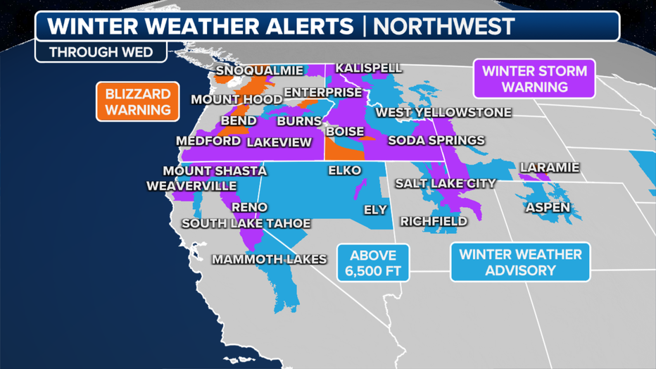
Current weather alerts. (FOX Weather)
For the rest of the Inland Northwest, widespread Winter Storm Warnings cover much of Idaho and eastern Oregon for up to 6 inches of snow in the lower elevations and up to 2 feet in the higher elevations.

Trees falling, power outages caused by strong winds in Western WA
Strong winds are causing numerous issues for people in the Puget Sound region. On Tuesday morning, a homeowner in Federal Way woke up to a tree falling onto their home. Good Day Seattle is also tracking numerous power outages across the area.
And the storm's effects will eventually reach south into California, where Winter Storm Warnings are posted in the Siskiyous and Sierra Nevada for Wednesday into early Thursday for again gusty winds combining with several inches of snow. Wind gusts along the peaks of the Sierra could reach 80-100 mph, while snow totals will reach 1-3 feet in the higher elevations.
7 WAYS TO STAY SAFE WHILE USING A GENERATOR
The term "bomb cyclone" comes from the meteorological term "bombogenesis" or "explosive cyclogenesis." This happens when a storm system's central pressure drops at least 24 millibars within 24 hours. Surface analysis showed this storm dropped 29 millibars in 24 hours before making landfall on Vancouver Island.
Massive waves, coastal flooding likely too
The strong storm's winds and deep low pressure are combining with another round of king tides to present a threat of coastal flooding and heavy surf along the Pacific Northwest coasts and beaches.
Coastal Flood Warnings are in effect along the Washington coast for 2-3 feet of flood inundations along shorelines and low-lying coastal areas.
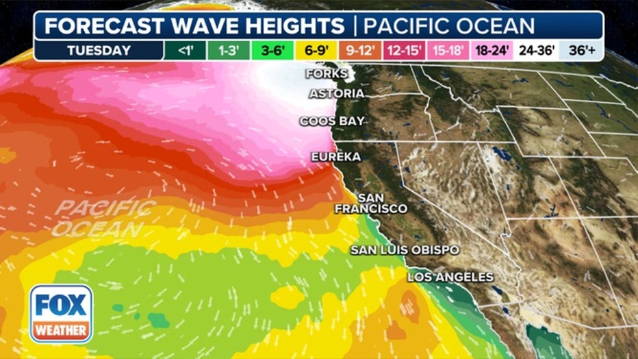
"Significant coastal flooding due to high tides and storm surge is expected," the National Weather Service said. "This is expected to lead to numerous road closures. Low-lying property, including homes, businesses and some critical infrastructure may be inundated."
Waves may reach 15-30 feet along the Washington coast and up to 29-33 feet along the Oregon coast, presenting grave dangers for beach gawkers. "People can be swept off rocks and jetties and drown while observing high surf," the NWS warned.
More winter storms loom
While there may be a brief break in the weather Wednesday, another round of wintry weather is forecast for Thursday into the weekend across the Pacific Northwest.
HOW TO DRIVE IN ICY CONDITIONS
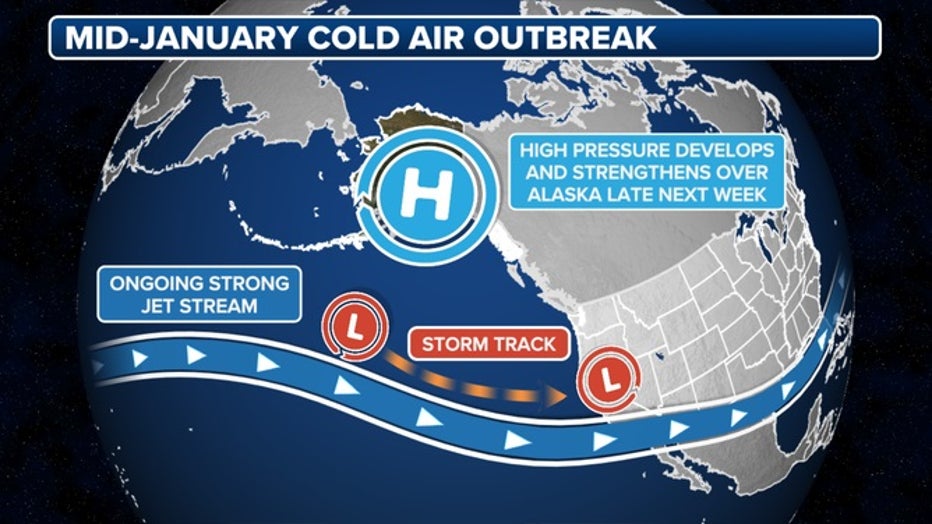
An arctic air mass dropping out of Canada is expected to bring the coldest temperatures of the winter so far, along with another threat of wintry precipitation.