

Seattle weather: Breezy, wet end to weekend
Seattle weather: Soggy weekend start for western WA
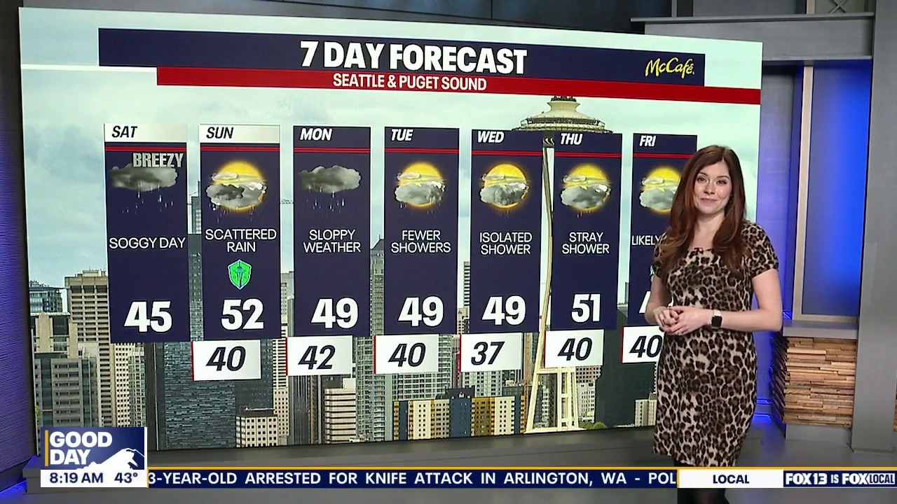
While the coastal regions in western Washington are gusty, as well as in the Cascade gaps, the greater Puget Sound region is seeing a wet and soggy Saturday. Some relief from the rain is expected for parts of Sunday.
SEATTLE - A deep low in the Pacific will force a series of fronts through the region. The first brought rain to the area on Saturday, with the second quickly on its heels arriving early Sunday.
Lowland rain, heavy at times, will be possible, especially along the coast. Snow levels around 3000' will lead to mountain snow. Keep an eye on mountain passes if you are driving.

The next in a series of fronts arrive with additional rain and mountain snow.
The front will lead to gusty winds through the Cascade Gaps and along the coast. Winds will be strongest late Saturday night and early Sunday with gusts nearing 50 mph.

Gusty winds around the regional early Sunday morning.
A wind advisory will be in effect till 10am Sunday for the Cascade gap and coastal region. Winds will relax during the day on Sunday; gusts will be closer to 20–25 mph, well below the wind advisory criteria.

Gusty winds on Sunday morning near 50 mph.
Afternoon highs on Sunday will be a few degrees warmer, closer to normal in the upper 40s and low 50s.

Afternoon highs near normal in the upper 40s and low 50s.
The week ahead will remain unsettled with additional chances for rain and mountain snow. Highs will be close to seasonal averages this week with overnight lows above freezing.

Seattle weather trends drier by Saturday with improving conditions and a few more breaks of sunshine. (FOX 13 Seattle)
MORE NEWS ON FOX 13 SEATTLE
High profile bills in Olympia die with just weeks to go
Democrat policy researchers develop plan to cap grocery prices
Man charged in arson, assault at Seattle's Harborview Medical Center
Who could buy the Seattle Seahawks as franchise could sell for $8B
Inside Mike Macdonald’s decision to trust Brian Fleury as new Seattle Seahawks offensive coordinator
To get the best local news, weather and sports in Seattle for free, sign up for the daily FOX Seattle Newsletter.
Download the free FOX LOCAL app for mobile in the Apple App Store or Google Play Store for live Seattle news, top stories, weather updates and more local and national news.