

Seattle weather: Rain, wind, mountain snow ahead Tuesday
Seattle weather: Few showers on tap for Monday
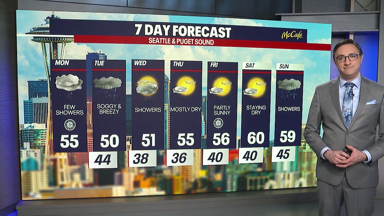
Showers will stretch into Monday morning with high in the mid 50s.
SEATTLE - This week will feature showers, wind, mountain snow, and then a much-needed dry and warmer stretch just in time for the weekend in Western Washington.
Onshore flow is still in control this evening, keeping scattered showers around, especially across the interior and into the Cascades. If you’re in King or Snohomish County, you may notice a few extra pockets of rain thanks to the Puget Sound Convergence Zone.

It will be cloudy with a few light scattered showers Monday night in Western Washington. (FOX 13 Seattle)
By the numbers:
In the mountains, snow levels are dropping to around 4,000 feet, so higher elevations will continue to pick up fresh snow.
Tuesday will bring steady rain by the afternoon with breezy gusts of 20 to 30 mph (strongest in the evening). Daytime highs will struggle to make it to 50 degrees in Seattle.

Widespread rain returns to the lowlands and widespread snow to the mountains Tuesday afternoon. (FOX 13 Seattle)
In the Cascades, this will be a significant winter-like storm. Snow levels will be around 3,500 feet Tuesday and will drop to near 2,000 feet Wednesday. All mountain passes look likely to see some snow. A winter storm watch in effect for the Washington Cascades.

Significant late-season snow will hit the Washington Cascades Tuesday into Wednesday. (FOX 13 Seattle)
Weather to quiet down by the weekend
What's next:
By Wednesday, the airmass turns a bit unstable, so don’t be surprised if you hear a rumble of thunder mixed in with showers in the lowlands. Things begin to quiet down Wednesday night as the system exits.
High pressure will build in late this week, bringing a much calmer stretch of weather. Thursday & Friday will be dry with sunshine, but both days will bring chilly mornings. Some areas, especially around the South Sound, could see frost.
On Saturday, the ridge shifts overhead, boosting temperatures into the low 60s around Seattle with more sunshine. A weak system could bring showers on Sunday.

After a very wet and breezy Tuesday, the Seattle area will dry out starting Wednesday afternoon. (FOX 13 Seattle)
MORE NEWS FROM FOX 13 SEATTLE
WA Gov. Ferguson says state will prevail against ‘millionaires tax’ lawsuit
Waymo, Waze team up to help fix Seattle's potholes
Man 'lucky' to survive Seattle shooting after bullet grazes his head
Kraken CEO Leiweke: "We are not happy. We are going to get better."
Amazon Flex driver in WA arrested after pile of stolen packages found
To get the best local news, weather and sports in Seattle for free, sign up for the daily FOX Seattle Newsletter.
Download the free FOX LOCAL app for mobile in the Apple App Store or Google Play Store for live Seattle news, top stories, weather updates and more local and national news.
The Source: Information in this story comes from weather models interpreted by the FOX 13 Seattle weather team.