

Seattle weather: Soggy, active weather on Saturday

Early showers Friday, rain & mountain snow this weekend
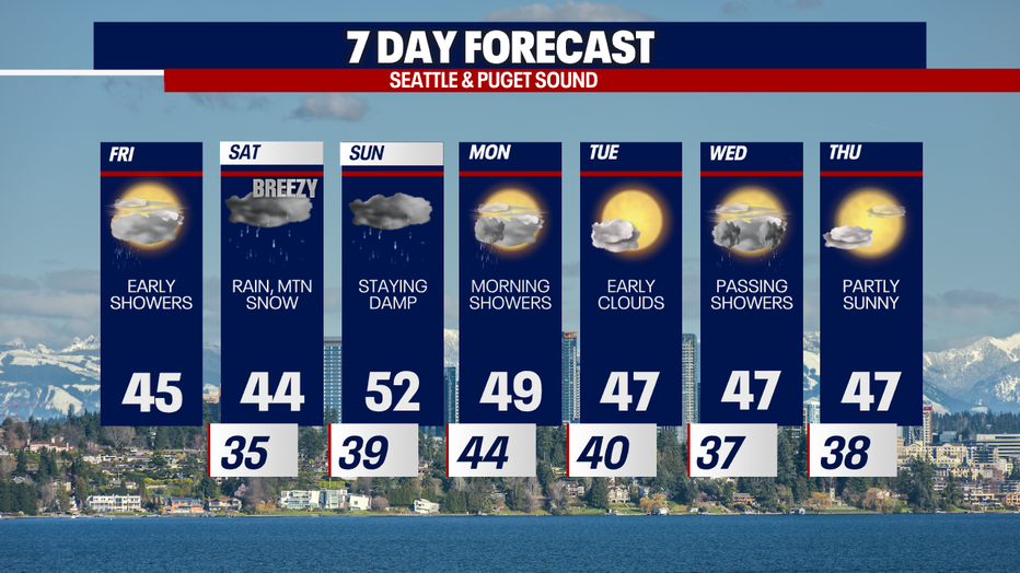
Seattle weather: Early showers Friday, rain & mountain snow this weekend
SEATTLE - Buckle up for seriously soggy weather on Saturday. We are tracking cold lowland rain, mountain snow and localized strong winds tomorrow. If the right ingredients come together, there may be pockets of brief lowland snow tomorrow.

Today, there's still a Winter Weather Advisory in effect until 1 p.m. An extra one to two inches of snow is possible for Stevens and Snoqualmie Passes. Elsewhere, we can't rule out a light shower, but most backyards will be dry this afternoon.

Today, you can plan on mostly cloudy skies, cool highs in the mid to upper 40s and a few glimpses of sunshine.

A Flood Warning for the Chehalis River at Porter is posted until Saturday morning. There's also a Flood Watch for the Skokomish River in Mason County: minor to moderate river flooding is possible this weekend.

Even though we're forecasting yet another atmospheric river weather pattern this weekend, it won't trigger the level of flooding caused by the string of atmospheric rivers we had a few days ago. Widespread river flooding isn't likely this weekend, but we'll need to closely watch water levels over the next few days.
Take a look at the forecast for rain totals through Sunday:


Initially on Saturday, the atmosphere will be chilly. Take a look at overnight lows below flirting with the freezing mark.

Where heavy downpours develop before 1-3 p.m. tomorrow, the atmosphere may cool enough locally to produce snow in some of the lowlands or foothills. The areas with the best chance for sleet, snow, or a "chunky rain" (rain/snow mix) will be the Hood Canal, higher hilltops of the Kitsap Peninsula and east of I-5 in Whatcom and Skagit Counties (though that isn't to say it couldn't happen elsewhere). If the atmosphere cools enough and the lowland snow is persistent, there could be a quick 1-2" or less accumulating – this would melt quickly as any snow rapidly transitions to rain in the afternoon. Again, the chance of this happening is small but worth a mention.


Snow at the passes through Saturday night could be impressive with totals amounting to a foot or more at the passes. As of 11:30 a.m. Friday, the National Weather Service hasn't issued alerts for Saturday yet, but stay tuned! Traveling over the passes could be extraordinarily difficult on Saturday. Visibility could be rather low when an intense snow rate is combined with gusty conditions.
Snow levels rise to about 6,000 feet in elevation on Sunday. This means that a good amount of the freshly accumulated snow from Saturday could melt.

Let's talk about the winds. Gusts could reach 40-50 mph for the coast, San Juans and Whidbey Island. Elsewhere, winds will blow between 20-30 mph (isolated cases of 40 mph elsewhere). Where winds are strong, we can't rule out power outages or minor damages.
The weather next week looks much quieter than this weekend. In fact, we might enjoy a couple of dry days (which at this point look to be Tuesday and Thursday).
Thanks so much for choosing FOX 13! We appreciate you so much.
Warmly,
Meteorologist Abby Acone
Follow me on X @abbyacone, Instagram @abbyaconewx, TikTok @abbyaconetv and Facebook (Meteorologist Abby Acone)