

Hurricane Otis makes historic Category 5 landfall as 'nightmare scenario' unfolds near Acapulco, Mexico

People rest at the beach after Hurricane Otis' arrival alert in Acapulco, Guerrero state, Mexico on October 24, 2023. A new Category 3 hurricane, driven by winds exceeding 200 km/h, threatens Acapulco, the tourist capital of the Pacific on the west c
Hurricane Otis made a historic landfall near Acapulco, Mexico, at Category 5 intensity early Wednesday, packing destructive winds up to 165 mph after rapidly intensifying just hours before reaching the coast.
According to the National Hurricane Center (NHC), Otis made landfall some 5 miles south of Acapulco around 1:25 a.m. CDT Wednesday. Otis was the strongest hurricane to ever make landfall on the Pacific side of Mexico. It was also the first time an Eastern Pacific hurricane made landfall at Category 5 intensity.
OTIS TRACKER: LIVE INFORMATION, CURRENT WATCHES AND WARNINGS, FUTURE PATH AND MORE
The NHC said catastrophic damage was likely where the hurricane's core moved onshore.
"A nightmare scenario is unfolding for southern Mexico this evening with rapidly intensifying Otis approaching the coastline," the NHC warned in its forecast discussion Tuesday night after Otis intensified at an explosive rate. "… This is an extremely serious situation for the Acapulco metropolitan area with the core of the destructive hurricane likely to come near or over that large city early on Wednesday. There are no hurricanes on record even close to this intensity for this part of Mexico."
BRYAN NORCROSS: HURRICANES OTIS AND TAMMY BOTH SURPRISINGLY AND SUDDENLY INTENSIFY

People stand on the beach after Hurricane Otis' arrival alert in Acapulco, Guerrero state, Mexico on October 24, 2023. A new Category 3 hurricane, driven by winds exceeding 200 km/h, threatens Acapulco, the tourist capital of the Pacific on the west
Residents in southern Mexico were warned to brace for a "potentially catastrophic" storm surge with "life-threatening" coastal flooding, huge waves, destructive winds and flooding rainfall.
"Hurricane Otis has intensified by 80 mph in the past 12 hours (from 65 mph to 145 mph)," Colorado State University hurricane specialist Phil Klotzbach wrote on X (formerly Twitter) Tuesday evening when the storm intensified to a Category 4 hurricane. That's the fastest 12-hour intensification rate in the eastern North Pacific (to 180°) in the satellite era (since 1966), breaking the old record of 75 mph/12 hours set by Patricia in 2015."
WHICH HURRICANES RAPIDLY INTENSIFIED BEFORE US LANDFALL?
President Andres Manuel López Obrador held a news conference Wednesday and reported that communication within the state of Guerrero, where Acapulco is located, has been disrupted.
Officials are working to restore communication and assess damage after reports of landslides. No fatalities have been reported.
At last check, the Federal Electricity Commission (CFE) said it had restored power to 40% of the 1.37 million electricity customers in Guerrero.

A municipal police officer stands guard before the arrival of Hurricane Otis in Acapulco, Guerrero state, Mexico on October 24, 2023. A new Category 3 hurricane, driven by winds exceeding 200 km/h, threatens Acapulco, the tourist capital of the Pacif
As of 2 p.m. EDT, the NHC said Otis had weakened to a tropical storm after maximum sustained winds decreased to near 60 mph. Continued rapid weakening is expected while Otis moves farther inland over the mountains of Mexico.
Otis will likely dissipate over southern Mexico on Wednesday night, the NHC added.
Tropical Storm Otis is expected to produce additional rainfall totals between 4 and 6 inches, with maximum amounts up to 8 inches, through Thursday across Guerrero and the western coastal sections of Oaxaca. This rainfall will produce flash and urban flooding, along with mudslides in higher-terrain areas.
Another disturbance likely to develop south of Central America, Mexico
According to the NHC, a broad area of low pressure has formed over the far Eastern Pacific, partially related to the remnants of former Atlantic Tropical Depression Twenty-One.
Environmental conditions should be conducive for the development of this system, and a tropical depression is expected to form late this week or this weekend while the area of low pressure moves slowly westward to west-northwestward.
The NHC gives it a high chance of development over the next five days.
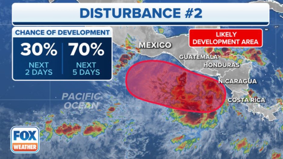
Here's a look at the chance of development for a disturbance in the Eastern Pacific Ocean. (FOX Weather)