

Sunshine on Tuesday, on and off showers Wednesday
Enjoy the sunshine Tuesday because it?s coming to an end.
Enjoy the sunshine Tuesday because it?s coming to an end.


Enjoy a dry Tuesday before our next storm hits Wednesday with more rain and wind!
A beautiful, dry Fall day across the Pacific Northwest. Most of us not only enjoying the break from the rain, but some blue skies peeking through the cloud cover. Monday's highs running cooler than average again. Normal for this time of year is 60 and will drop to 59 Tuesday.
A beautiful, dry Fall day across the Pacific Northwest. Most of us not only enjoying the break from the rain, but some blue skies peeking through the cloud cover. Monday's highs running cooler than average again. Normal for this time of year is 60 and will drop to 59 Tuesday.
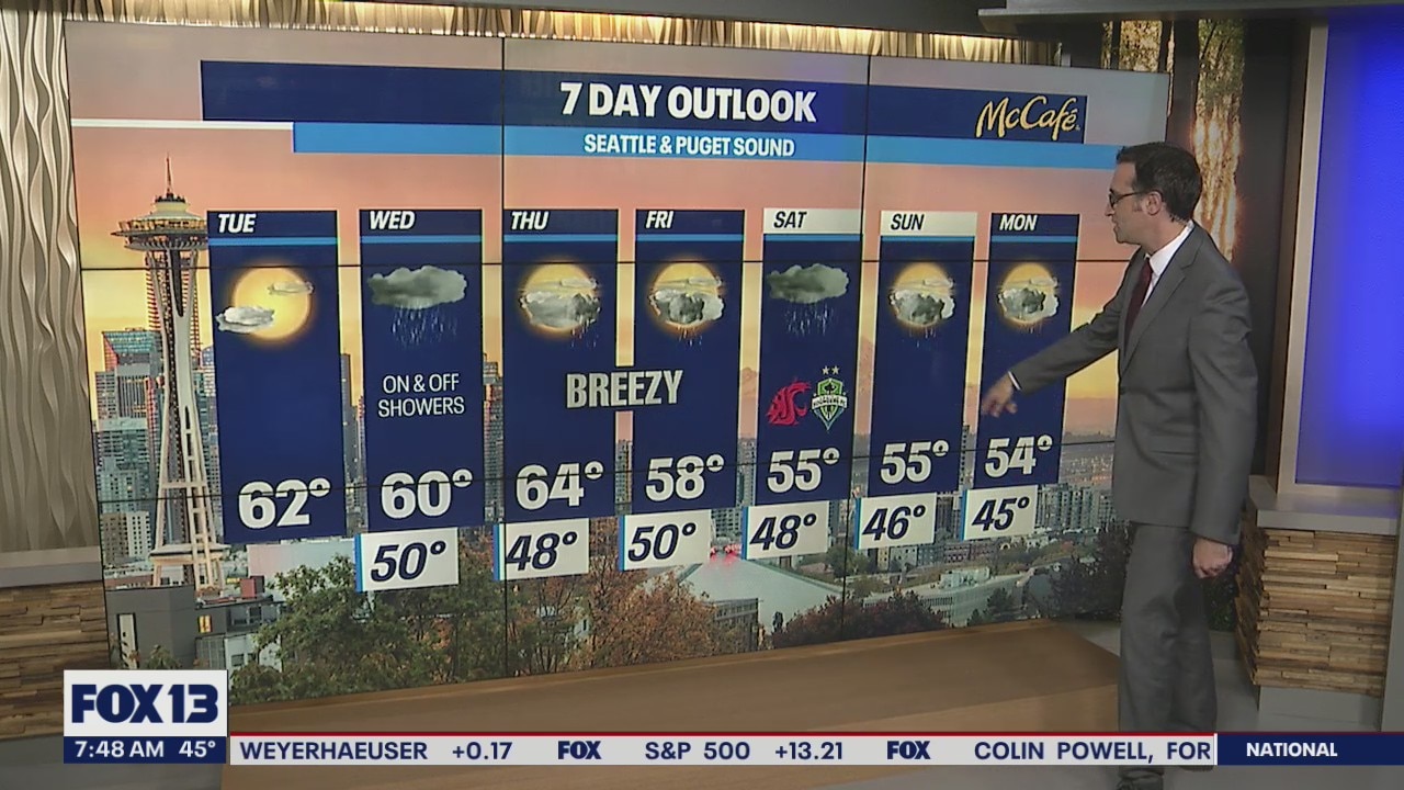
Rain AND shine this week with moderate temperatures
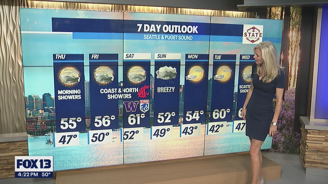
FOX 13 Forecaster Erin Mayovsky is tracking just about every king of weather this week!
FOX 13 Forecaster Erin Mayovsky is tracking just about every king of weather this week!


Harris to discuss drought, Biden climate change proposal at Lake Mead
Vice President Kamala Harris on Monday will visit Lake Mead in Nevada to highlight the problems caused by Western drought.
Vice President Kamala Harris on Monday will visit Lake Mead in Nevada to highlight the problems caused by Western drought.


Dry the next two days, then wet weather returns
We will have a nice break from the rain through Tuesday. High temperatures will make it into the mid 50s today with mostly cloudy skies and some afternoon sunbreaks.
We will have a nice break from the rain through Tuesday. High temperatures will make it into the mid 50s today with mostly cloudy skies and some afternoon sunbreaks.

Mostly cloudy skies, mainly dry conditions
Highs will inch their way back to the upper 50s to low 60s through the work week with favorable Autumn weather Monday and Tuesday.
Highs will inch their way back to the upper 50s to low 60s through the work week with favorable Autumn weather Monday and Tuesday.


A break between systems as we start the work week. Highs climb to near 60!
We managed to stay mostly dry around the Seattle area Sunday. Highs were slightly cooler than average too, landing in the mid to upper 50s around the region.
We managed to stay mostly dry around the Seattle area Sunday. Highs were slightly cooler than average too, landing in the mid to upper 50s around the region.

Spotty showers with some glimpses of sunlight!
FOX 13 Forecaster Grace Chapin is tracking a wet week. But don't despair, we're seeing some chances for sunlight to peek through!
FOX 13 Forecaster Grace Chapin is tracking a wet week. But don't despair, we're seeing some chances for sunlight to peek through!


A cool & showery Sunday on the way for many with Autumn sunshine returning to start the week.
What a pretty Saturday around Puget Sound! Many of us enjoying Fall warmth and some blue skies, while others, along the Coast and North Sound taking in a few showers.
What a pretty Saturday around Puget Sound! Many of us enjoying Fall warmth and some blue skies, while others, along the Coast and North Sound taking in a few showers.
On and off showers through the upcoming week
FOX 13 Forecaster Grace Chapin is tracking some intermittent showers throughout the week.
FOX 13 Forecaster Grace Chapin is tracking some intermittent showers throughout the week.


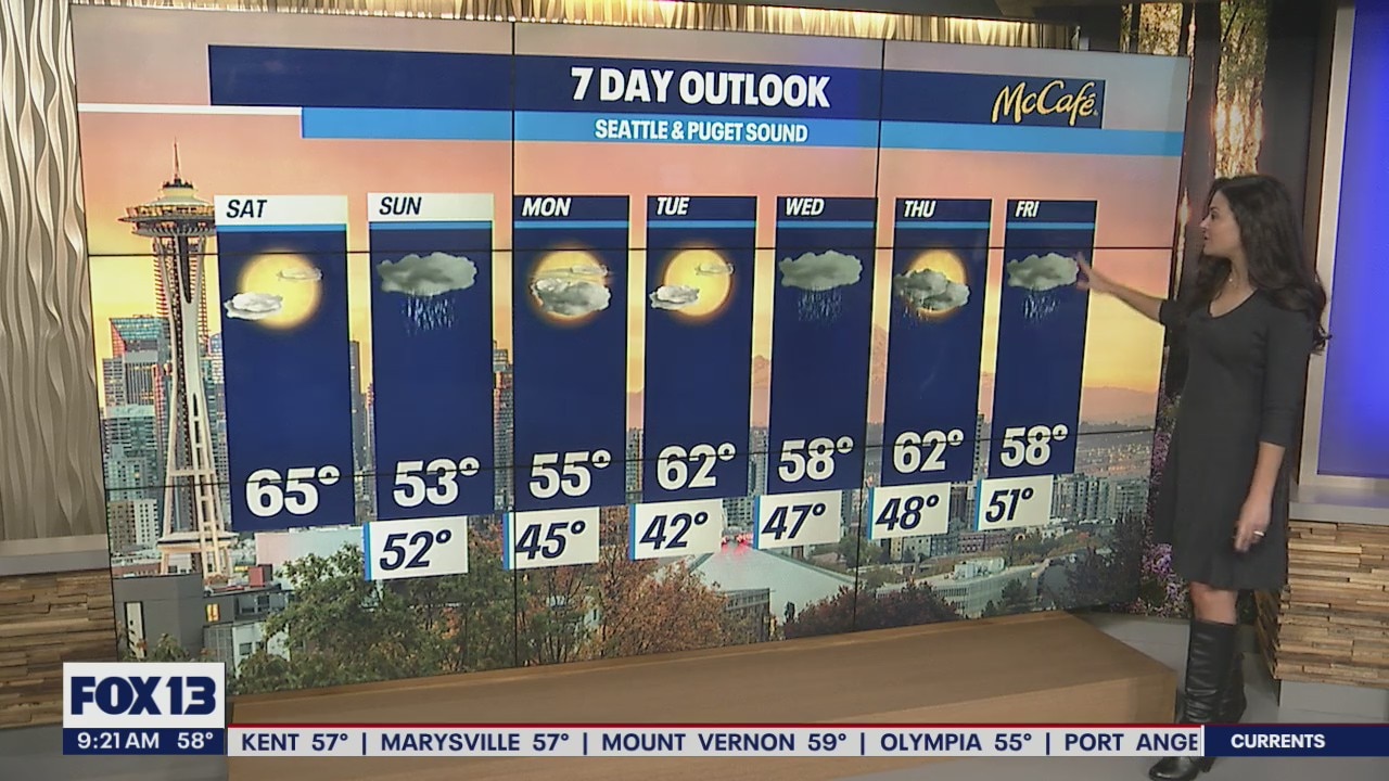
More rain for some while others dry out into Saturday before a widespread showers take over Sunday
Welcome to the weekend all! We're tracking a bit of everything over the next week so if you don't like the weather one day wait for the next and you'll probably find something you like.
Welcome to the weekend all! We're tracking a bit of everything over the next week so if you don't like the weather one day wait for the next and you'll probably find something you like.


Flood risk threatens 25% of critical US infrastructure, research shows
Flooding isn’t just a threat to our roads. A new study conducted by First Street Foundation found it threatens our police stations, fire stations, hospitals and water treatment facilities.
Flooding isn’t just a threat to our roads. A new study conducted by First Street Foundation found it threatens our police stations, fire stations, hospitals and water treatment facilities.

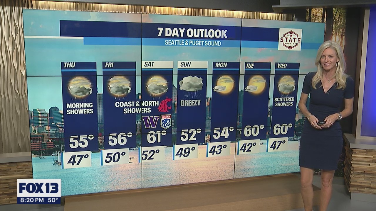
Very wet Friday and Saturday for the coast and north sound
Rain has returned this morning as a wet system takes aim on the northern Washington Coast and the northern Puget Sound area.
Rain has returned this morning as a wet system takes aim on the northern Washington Coast and the northern Puget Sound area.


Very wet Friday and Saturday for the coast and north sound
Rain has returned this morning as a wet system takes aim on the northern Washington Coast and the northern Puget Sound area. The Seattle area and south sound will get hit with some lighter showers today, but the bulk of the rain will be aimed farther north. The northern Washington Coast will be hit the hardest with 2-3+ inches of rain possible. A half inch to an inch and a half is expected from Snohomish County north to the border. Highs today will be around 60°.
Rain has returned this morning as a wet system takes aim on the northern Washington Coast and the northern Puget Sound area. The Seattle area and south sound will get hit with some lighter showers today, but the bulk of the rain will be aimed farther north. The northern Washington Coast will be hit the hardest with 2-3+ inches of rain possible. A half inch to an inch and a half is expected from Snohomish County north to the border. Highs today will be around 60°.


Heavy rain for some areas Friday and Saturday
It’s a mild and wet morning across western Washington. Scattered showers will continue the next few hours and will eventually taper off as we head into the late morning and early afternoon.
It’s a mild and wet morning across western Washington. Scattered showers will continue the next few hours and will eventually taper off as we head into the late morning and early afternoon.

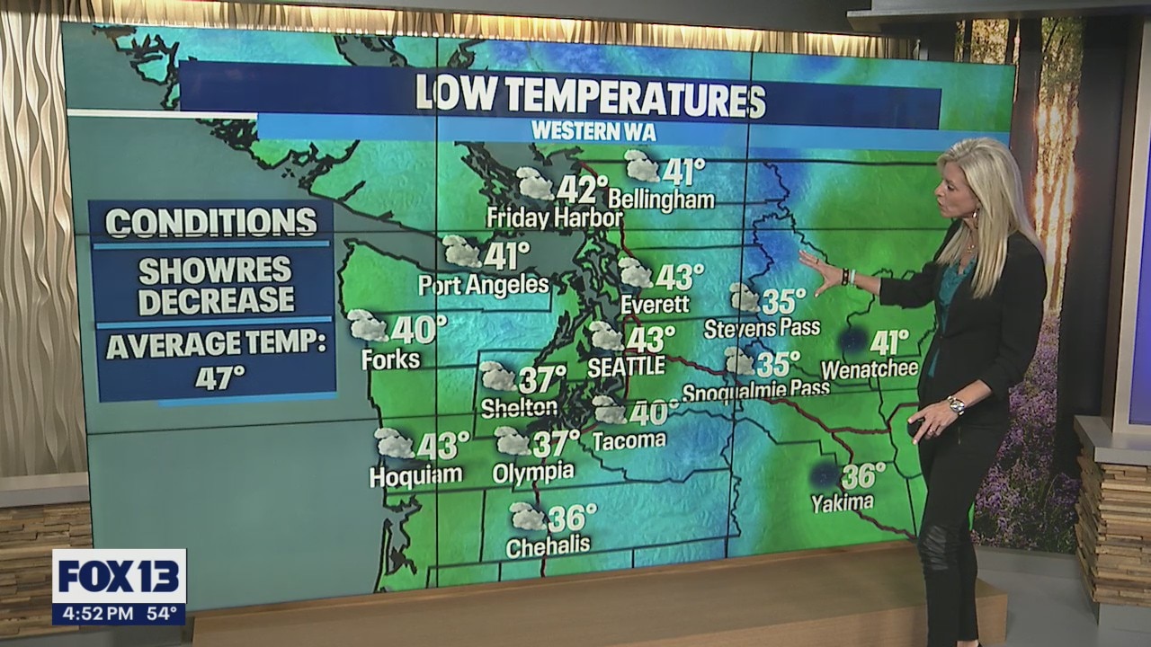
Mostly cloudy skies, drier conditions
Showers are going to dissipate and we?ll be looking at mostly cloudy skies and drier conditions for some areas.
Showers are going to dissipate and we?ll be looking at mostly cloudy skies and drier conditions for some areas.


Fall is settling in around the Northwest as cool and showery conditions drive the forecast.
We're dealing with typical October weather as we settle into Autumn. Showers and cooler highs will remain the theme through the first part of the weekend.
We're dealing with typical October weather as we settle into Autumn. Showers and cooler highs will remain the theme through the first part of the weekend.
Showers expected for the rest of the week
FOX 13 meteorologist Erin Mayovsky has the latest forecast
FOX 13 meteorologist Erin Mayovsky has the latest forecast
Rainy and breezy end to the week
FOX 13 Forecaster Erin Mayovsky has your 7-day forecast, and it's going to be a rainy one!
FOX 13 Forecaster Erin Mayovsky has your 7-day forecast, and it's going to be a rainy one!


Pamela moves inland after slamming Mexico's Pacific coast as hurricane
Pamela continued moving inland after making landfall on Mexico’s Pacific coast near the resort city of Mazatlan.
Pamela continued moving inland after making landfall on Mexico’s Pacific coast near the resort city of Mazatlan.