


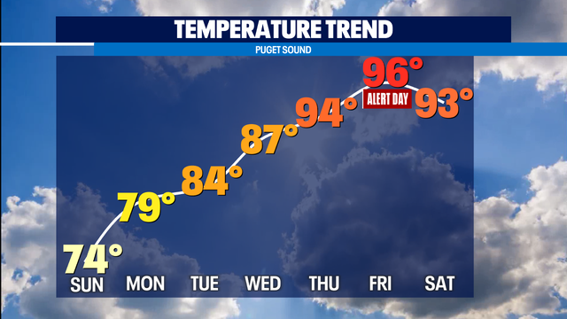
Heating up: Excessive Heat Watch issued for Western Washington
After our comfortable weekend with a little rain, we're drying up, sunning up and heating up again.
After our comfortable weekend with a little rain, we're drying up, sunning up and heating up again.


'Dog Days of Summer' to end just as new heat wave blasts Northwest
The so-called "Dog Days of Summer" officially end on Wednesday if you go by the original definition, but someone might want to see if there's room to grant an extension in 2021 as another stretch of very hot weather looms for the Pacific Northwest this week.
The so-called "Dog Days of Summer" officially end on Wednesday if you go by the original definition, but someone might want to see if there's room to grant an extension in 2021 as another stretch of very hot weather looms for the Pacific Northwest this week.

Temperatures climbing back into the 90s this week in Western Washington
Q13 News Meteorologist M.J. McDermott has a hot 7-day forecast for Western Washington.
Q13 News Meteorologist M.J. McDermott has a hot 7-day forecast for Western Washington.
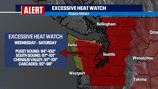

Excessive Heat Watch This Week
Happy Sunday! Where you able to enjoy the “cooler” weather this weekend? I hope so because we are turning up the heat this week. A Weather Alert Day will go into effect on Friday due to temperatures rising into the upper-90s. This will be record-breaking heat.
Happy Sunday! Where you able to enjoy the “cooler” weather this weekend? I hope so because we are turning up the heat this week. A Weather Alert Day will go into effect on Friday due to temperatures rising into the upper-90s. This will be record-breaking heat.
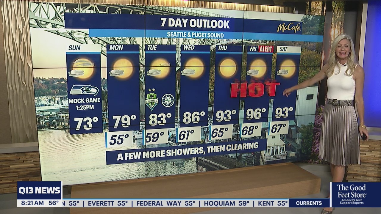
Temps only getting hotter this week
By Thursday, temperatures will be in the 90s
By Thursday, temperatures will be in the 90s

Cool today with a big warm up on the way through the week with mid 90s by Friday!
Look for skies to clear by mid-afternoon. Highs will land in the low 70s for the metro area with slightly warmer conditions into the foothills and farther south.
Look for skies to clear by mid-afternoon. Highs will land in the low 70s for the metro area with slightly warmer conditions into the foothills and farther south.

Convergent Zone Drizzle Tonight
Happy Saturday! I'm sure you loved the on and off drizzle throughout the day. We had a little bit of everything, including the sunshine! The temperatures remained below average, and the breeze picked up at times. Overnight lows will drop as the drizzle/shower activity will remain in the forecast.
Happy Saturday! I'm sure you loved the on and off drizzle throughout the day. We had a little bit of everything, including the sunshine! The temperatures remained below average, and the breeze picked up at times. Overnight lows will drop as the drizzle/shower activity will remain in the forecast.


Cool and showery today, then heat starts to kick in to gear with 90s coming our way next week
Showers will hang around tonight and through the overnight hours into early Sunday morning before starting to wrap up. Look for partly sunny skies by mid-afternoon with highs warming into the mid 70s, still cooler than average.
Showers will hang around tonight and through the overnight hours into early Sunday morning before starting to wrap up. Look for partly sunny skies by mid-afternoon with highs warming into the mid 70s, still cooler than average.

Mild weekend before temperatures reach 90s late next week
Q13 Forecaster Erin Mayovsky has a look at your 7-day forecast.
Q13 Forecaster Erin Mayovsky has a look at your 7-day forecast.


Shower chances continue this weekend!
Happy Friday! What a day. We ended our dry streak with some drizzle and light showers overnight and early this morning. The officially reading was taken at SeaTac 10 minutes before midnight at 0.01". The drizzle and shower activity will return tomorrow adding to the accumulation we saw this morning! Along with the precipitation, we can expect cooler temperatures and cloudy skies. Enjoy the changes because they will be short lived.
Happy Friday! What a day. We ended our dry streak with some drizzle and light showers overnight and early this morning. The officially reading was taken at SeaTac 10 minutes before midnight at 0.01". The drizzle and shower activity will return tomorrow adding to the accumulation we saw this morning! Along with the precipitation, we can expect cooler temperatures and cloudy skies. Enjoy the changes because they will be short lived.


Cool weekend, but hot weather on the way next weeks
Weather forecast predicts lower temperatures with possible showers.
Weather forecast predicts lower temperatures with possible showers.


Seattle's nearly record-long dry streak ends at 51 days
Mid 70s with a few showers predicted for this weekend.
Mid 70s with a few showers predicted for this weekend.


Rain won't make it over Cascades to help firefighters
Unfortunately, none of this beneficial rainfall will make it over the Cascades and help out the fire situation in Eastern Washington.
Unfortunately, none of this beneficial rainfall will make it over the Cascades and help out the fire situation in Eastern Washington.


Seattle's nearly record-long dry streak ends at 51 days
Just before the clock struck midnight Thursday night some raindrops struck the rain gauge at Sea-Tac Airport, ending a long streak of dry weather that challenged all-time records!
Just before the clock struck midnight Thursday night some raindrops struck the rain gauge at Sea-Tac Airport, ending a long streak of dry weather that challenged all-time records!


Towns burn to ashes, others unaccounted for as Dixie Fire rages through Sierra Nevada
As of Friday morning, the Dixie Fire had scorched more than 400,000 acres, giving it the unfortunate ranking of being California's third-largest wildfire in state history.
As of Friday morning, the Dixie Fire had scorched more than 400,000 acres, giving it the unfortunate ranking of being California's third-largest wildfire in state history.


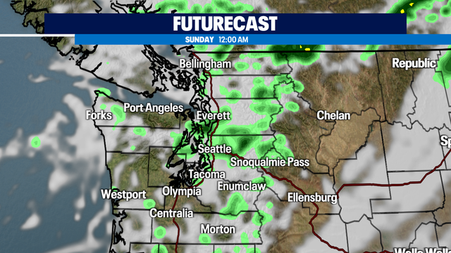
Will the dry stretch finally come to an end Friday with light rain moving inland?
Another stellar summer day around Puget Sound! Highs today soaring into the 80s again with Seattle landing seven degrees above average at 86. Puget Sound saw plenty of blue skies, but that soon will change as a system slides just to the north of us dropping in a few showers.
Another stellar summer day around Puget Sound! Highs today soaring into the 80s again with Seattle landing seven degrees above average at 86. Puget Sound saw plenty of blue skies, but that soon will change as a system slides just to the north of us dropping in a few showers.


Rain on Friday could end our dry streak
Today will be mostly sunny with more haze from wildfire smoke than we had yesterday. Temps will be a little above normal. Late in the day, high clouds will roll in ahead of the system bringing in some rain tomorrow.
Today will be mostly sunny with more haze from wildfire smoke than we had yesterday. Temps will be a little above normal. Late in the day, high clouds will roll in ahead of the system bringing in some rain tomorrow.


Rain Friday could end our dry streak
Q13 News Meteorologist M.J. McDermott has cooler temperatures in your 7-day forecast.
Q13 News Meteorologist M.J. McDermott has cooler temperatures in your 7-day forecast.


Devastating: Dixie Fire levels Gold Rush-era town of Greenville
Video shows a hotel, bar, gas station and many other buildings in Greenville, Plumas County, burned to the ground.
Video shows a hotel, bar, gas station and many other buildings in Greenville, Plumas County, burned to the ground.


51 days and counting without measurable rain at SeaTac, but the streak may come to an end.
Another above average high temperature day! We hit 88 Wednesday, but don't get used to the upper 80s because 70s are right around corner as a weak front approaches Puget Sound.
Another above average high temperature day! We hit 88 Wednesday, but don't get used to the upper 80s because 70s are right around corner as a weak front approaches Puget Sound.