

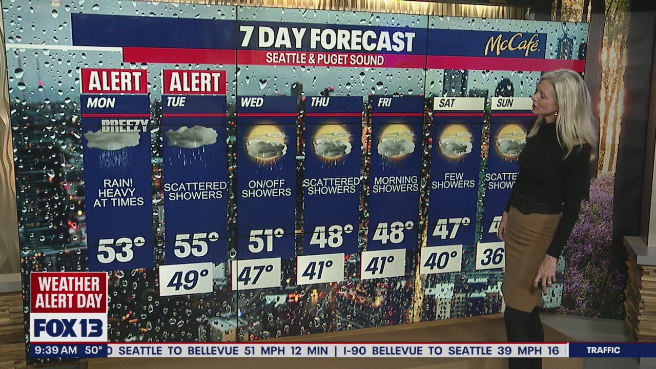
Another 'Weather Alert Day' as rain, wind slam Western Washington
Heavy rain continues to hit Western Washington
There could be upwards of 2-5" of rain falling in the lowlands and Cascades today through Tuesday morning.
SEATTLE - It's a messy Monday for sure and that is why the FOX 13 Weather Team is keeping us under Weather Alerts through Tuesday as a plume of moisture continues to pump into Western Washington.
Expect widespread showers today and at this point Seattle is heading towards setting a record for daily rain total (record to beat 1.46"). The rain will hang with us through early Wednesday before this latest atmospheric river moves out of the area.

Expect warmer temperatures along with heavy rain at times across the Sound and the mountains. Area rivers will become stressed as snow melt runs down into the lowlands.
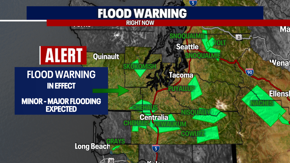
A "Flood Watch" will remain in effect through Wednesday afternoon for most counties around the region.
A "Flood Warning" also in effect for many area rivers as well. We're watching Mason County and the Skokomish River near Potlatch today as that portion of the river is expected to crest later this evening into tonight. And here is a list of several more rivers under the warning: Snoqualmie, Chehalis, Newaukum, Puyallup, Nisqually, Cowlitz, Tolt, and Naches.

The mountains are struggling to remain open and safe as snow levels sit between 6,500'-7,000'.
Stevens Pass is finally back open with "traction tires advised" after being closed through midday.
As of 2:30pm today Snoqualmie Pass is still closed due to the threat of Avalanches and dangerous conditions. Crews will continue to work and evaluate the situation with hopes to open by 5pm. Be prepared that the pasess could open and close again through tomorrow as heavy rain will fall for much of today.

Here's a look at rain totals through Wednesday night. Some spots could see upwards of two plus inches of rain in the bucket. Allow for extra time on the roads as ponding and hydroplaning will be an issue as long as rain continues to fall. Look for rising streams, creeks, and puddles to create problems communities around Puget Sound.

Rain will turn to showers by late Tuesday. Highs will run slightly warmer too, landing in the mid 50s.
As conditions start to ease mid-week much of our alerts will drop off, but unsettled weather will remain with us. There is a slight chance of thunderstorm activity Tuesday and Wednesday. Highs will fall into the upper 40s.
As we push into the weekend showers will become just scattered Thursday and Friday with some drying Saturday and Sunday! Stay tuned!
Have a great day and stay dry! ~Erin Mayovsky, FOX13 Forecaster

MORE FROM FOX 13 WEATHER:
DOWNLOAD: FOX 13 Weather and News Apps
WATCH: Forecast and Radar
READ: Closures and Delays
CHECK: Latest Weather Alerts and Live Traffic Map
INTERACT: Submit your Weather Photo
DAILY BRIEF: Sign Up For Our Newsletter
FOLLOW: Lisa Villegas, Erin Mayovsky, Brian MacMillan, Abby Acone and Scott Sistek