

Multiple atmospheric rivers ahead for Seattle on Christmas week
SEATTLE - Get ready for a wet, occasionally dark and blustery week ahead. Christmas and the holiday days following could be somewhat active and stormy with rounds of significant mountain snow, gusty weather, heavy rain and the risk of landslides and some river flooding.
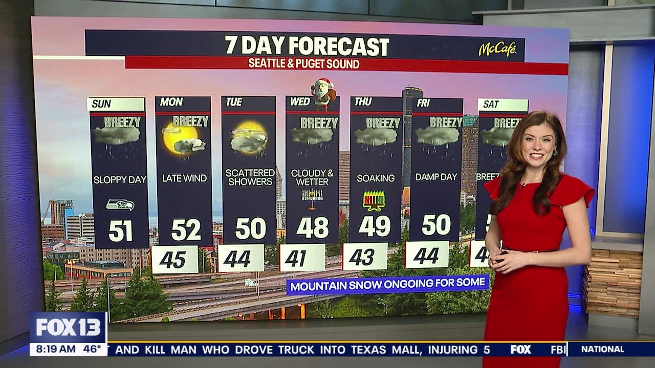
Soggy Sunday ahead
In the short term, we’re tracking a very waterlogged Sunday in western Washington. Rain will be steady throughout the afternoon.
There might be brief, minor snow over White or Stevens Pass today, but snow levels will be rising to 5,000 feet in elevation throughout the afternoon.
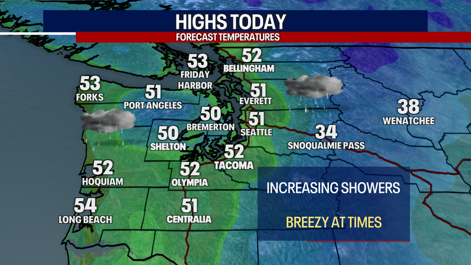
Temperatures will reach the low 50s around Western Washington on Sunday afternoon. (FOX 13 Seattle)
Strong winds will sweep over Washington coast
Until 5 p.m. today, there’s a Wind Advisory for the Central and North Coast. With gusts potentially reaching 45-50 mph, there may be some tree damage and power outages. Elsewhere, it’ll be blustery Sunday. We can’t rule out gusts elsewhere from blowing to 20-30 mph, but winds won’t be a widespread issue today.
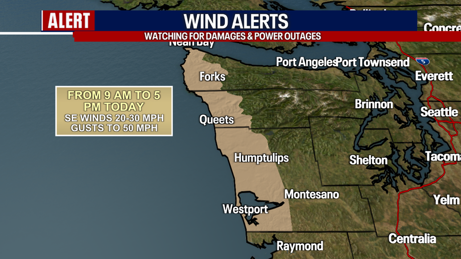
Windy weather is predicted west of Seattle along the Washington coast. (FOX 13 Seattle)
Western Washington lighning risks increasing on Christmas week
Along with pockets of heavy rain today, there may be lightning, small hail and graupel mixing with the rain. The best chance for thunder will be over the Kitsap Peninsula, the South Sound and the Olympic Peninsula.
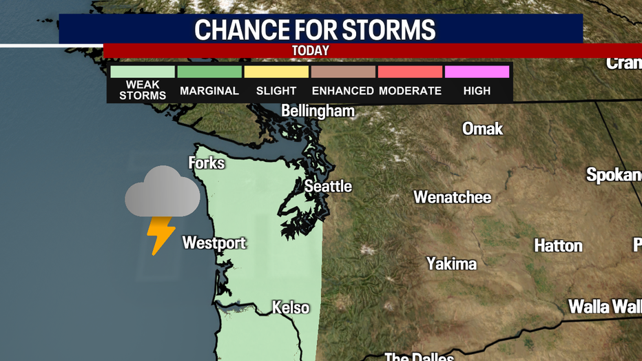
Lightning is possible west of Seattle in these highlighted areas. (FOX 13 Seattle)
Other alerts in effect
The South Washington Coast has a High Surf Advisory until 10 p.m. Monday. Keep a healthy distance from the water.
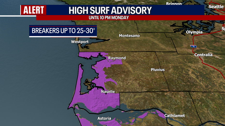
High surf is likely along the South Washington coast today and Monday. (FOX 13 Seattle)
A Flood Warning is posted for the Skokomish River until further notice for minor flooding. By the end of the week, other rivers may be rising. It’s difficult to pinpoint the impacts right now, but there might be a few issues by the end of the week.
Wet and gusty Monday evening
During the daytime on Monday, conditions look fairly quiet with partly cloudy skies, sunbreaks and fewer showers. Monday evening to Tuesday morning, there could be a brief stint of lowland rain, mountain snow and gusty conditions. Winds in the Cascade gap communities (e.g. North Bend and Enumclaw) could increase, potentially nearing Wind Advisory criteria for Monday night. Stay tuned for the latest!
Quieter weather on Tuesday
Based on the data we’re analyzing now, it seems like winds will gradually ease Tuesday morning. Tuesday will offer up mostly cloudy skies with light scattered showers.
Rounds of atmospheric rivers to begin on Christmas in Seattle
Christmas Day and the first night of Hanukkah could be semi-drenching with our first of multiple atmospheric rivers headed our direction. Between Christmas and next weekend, there will be a few potent weather systems moving through, triggering rounds of lowland rain, mountain snow and gusty weather. There’s still time for the forecast to evolve, but just know that conditions will be rapidly changing later this week! We’ll keep a close watch on what to expect. Check our forecast daily for updates.

We're tracking lowland rain, mountain snow and times of wind this upcoming week in Seattle. (FOX 13 Seattle)
Take good care,
Meteorologist Abby Acone

Top 25 search queries of 2024
A look back at the top 25 search queries that brought people to FOX 13 Seattle's website in 2024.
MORE NEWS FROM FOX 13
Summit at Snoqualmie announces opening day for skiers in WA
'Light Show Spectacular' in Lake Forest Park, WA
‘My heart is exploding with joy’: Holiday Hero’s Toy Run hits Federal Way Walmart
Sneak peek: Black artists market in Seattle
Visit Santa's toy lab at 'Kringle's Inventionasium' in Seattle
To get the best local news, weather and sports in Seattle for free, sign up for the daily Fox Seattle Newsletter.
Download the free FOX Seattle FOX LOCAL app for mobile in the Apple App Store or Google Play Store for live Seattle news, top stories, weather updates and more local and national coverage, plus 24/7 streaming coverage from across the nation.