

Weather Alert Day: Gusty winds, heavy rain and dangerous pass travel
Next week will be chilly... but not freezing!
FOX 13 Meteorologist Abby Acone is tracking an end to the week of ice and snow we've been spinning our wheels in!
SEATTLE - The mountains are getting slammed with heavy snow tonight. Extremely soggy weather is on tap for everyone in Western Washington.
A Winter Storm Warning is in effect from 4 p.m. today to 4 p.m. Monday. During this time, up to one to two feet of snow could fall over the passes! As much as 30 inches of snow could pile up along the highest peaks and volcanoes. Gusts to 45 mph will lower visibility dramatically. Driving will be difficult if not impossible along the passes tonight and Monday.

Winds will also be gusty today. A Wind Advisory is in effect for the Central and North Washington Coast and the western Strait. For the areas highlighted in tan, gusts to 40-50 mph could lead to damages and power outages. The Wind Advisory continues until 4 p.m. today for the Strait and through 1 a.m. Monday for the coast.

For the areas highlighted in pink, a High Wind Warning is in effect until 4 a.m. Monday. Gusts to 55 mph could down trees or tree limbs. For these areas, including communities like Bellingham, Anacortes and Mount Vernon, there's a higher chance for power outages.

In the lower elevations, heavy rain will sweep through Western Washington this afternoon and tonight. Bands of rain could be intense, dropping visibility quickly and making it tough to drive. There will be a lot of pooling and standing water on the roads. Please drive carefully!

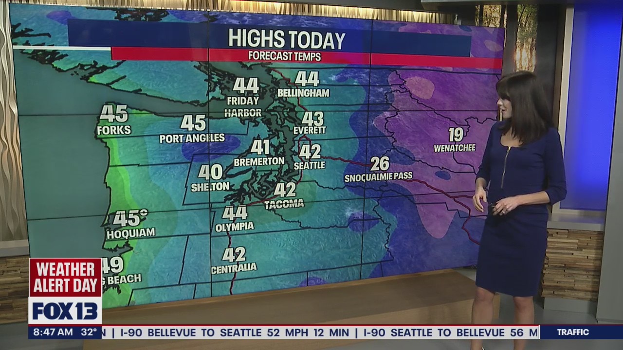
Highs today are warming to the low to mid 40s -- which means precipitation will mostly fall in the form of rain in the lowlands tonight!

However, there's a small chance there could be some snowflakes mixing with rain overnight and into Monday morning. Because temperatures will be so borderline, accumulations in the lower elevations are unlikely (higher hills may see a light accumulation). Even if there's a light coating of snow on the ground in the lower terrain, it should melt quickly because highs will once again boost to the 40s.

There are flood alerts in effect for the coastlines in Western Washington today. A Flood Watch is in effect for Southwest Washington due to rain and snow melt. There could be rising water levels on rivers, creeks and streams.

In the lime green, a Coastal Flood Advisory is in effect until 3 p.m. today. This is to account for minor tidal overflow which could flood parking lots and even roads. Remember to never drive into flooded waters!

Fewer showers are in the forecast Tuesday. Wednesday may end up as mostly dry! Thursday morning, there may be brief lowland snowflakes -- but that looks to change over to rain pretty quickly. Scattered rain is on tap for Friday. Saturday, only isolated showers look possible. Stay tuned for more!

However, there's a small chance there could be some snowflakes mixing with rain overnight and into Monday morning. Because temperatures will be so borderline, accumulations in the lower elevations are unlikely (higher hills may see a light accumulation). Even if there's a light coating of snow on the ground in the lower terrain, it should melt quickly because highs will once again boost to the 40s. We’re also tracking a small chance for thunderstorms along the coast Monday.
Thanks so much for choosing FOX 13! We're so grateful for your viewership.
MORE FROM FOX 13 WEATHER:
DOWNLOAD: FOX 13 Weather and News Apps
WATCH: Forecast and Radar
READ: Closures and Delays
CHECK: Latest Weather Alerts and Live Traffic Map
INTERACT: Submit your Weather Photo
DAILY BRIEF: Sign Up For Our Newsletter
FOLLOW: Lisa Villegas, Erin Mayovsky, Brian MacMillan, Abby Acone and Scott Sistek
FOX Weather: Streaming 24/7 from America's Weather Center