

Seattle weather: Major cooldown ahead for Western Washington
Seattle weather: Mountain snow today, big cooldown Thursday
Seattle weather: Mountain snow today, big cooldown Thursday
Western Washington: get ready for what could be a major cooldown starting Thursday! There could even be at least a little lowland snow by the latter part of the workweek.

In the meantime, we're tracking on-and-off lowland rain and mountain snow today. The heaviest of the snow has already fallen over the Olympics and the North Cascades, but the Central and South Cascades could get an extra three to ten inches of snow or more by early tomorrow morning. The highest totals later today will be near the Oregon state line and over Mount Rainier. Snow totals today are highly dependent on where the heaviest bands of snow develop. If you're traveling over the passes today, make sure your car is prepared for winter weather. Check WSDOT conditions before hitting the road, too.
Take a look at the alerts in effect:


Highs this afternoon will reach the mid to upper 40s for most.

Along the Pacific coast, a High Surf Advisory is in place until ten tonight. For the Central and North Coast, there could be large breaking waves at 14 to 18 feet. For the South Coast, breakers to 20 feet are a possibility. Localized beach erosion could be an issue as well.

For the coastal communities and Southwest Washington, pockets of drenching rain could develop today. Along the Olympic Peninsula, weak thunderstorms can't be ruled out.


In the wee hours of the morning today, winds were rather gusty. Winds are easing and will continue to relax today for most.
Tomorrow will be a well-earned break from the recent wet and dreary weather. Clouds and isolated fog are forecast in the morning, but sunbreaks will grace our skies tomorrow afternoon.
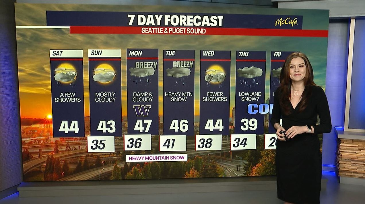
Starting Monday, active and stormy weather returns to Western Washington. Significant mountain snow will fall, particularly Tuesday. We're talking about feet of snow falling over the higher terrain into Wednesday. In the lower elevations, times of soaking rain are expected (especially Tuesday). Winds could be a factor as well, but there's still some uncertainty about how strong those winds could be.
Wednesday's forecast is a little up in the air: snow could continue falling over the passes. Scattered showers are still possible in the lowlands. Stick with us for updates in the coming days.
Beginning Thursday (and potentially lingering into next weekend), we're forecasting what could be a dramatic cooldown. There are still question marks about just how cold the temperatures could be. The weather models we analyze to make our predictions are somewhat split as to how frigid our air will get. However, there's a decent bet that highs will sag into the 30s. Based on the data right now, there's a low chance for light lowland snow at times, but it's not a slam dunk. Stay tuned as we closely watch what to expect. There's still plenty of time for the forecast to change in any direction!

Though there's a retractable roof in Phoenix tomorrow, Hawks fans coming in and out of the stadium at Sunday's game can expect showers and breezy weather. For the big Huskies game on Monday night in Houston (yet another retractable roof situation), there's a slight chance for severe storms and highs in the mid 60s. Go Dawgs and Go Hawks!


Thanks so much for choosing FOX 13. We're thankful for you!

Have a wonderful weekend,
Meteorologist Abby Acone
Follow me on Facebook (Meteorologist Abby Acone), Instagram @abbyaconewx, TikTok @abbyaconetv and X @abbyacone