Weather Alert for this holiday weekend: Tracking lowland & mountain snow as a cold airmass takes the area

Seattle - Get ready for an interesting weekend as a cold air-mass settles into the region. Not only will temperatures take a deep dive, but there's the potential for lowland snow across the state.
Before we get to the snow, there are some Flood Alerts to be aware of through Friday morning. Areas near Puget Sound may see minor flooding as water is pushed up over banks onto beaches and streets. Most of Puget Sound is under a "Coastal Flood Advisory".
And we're watching Mason County too where the Skokomish River near Potlatch is under a "Flood Warning" through the weekend.

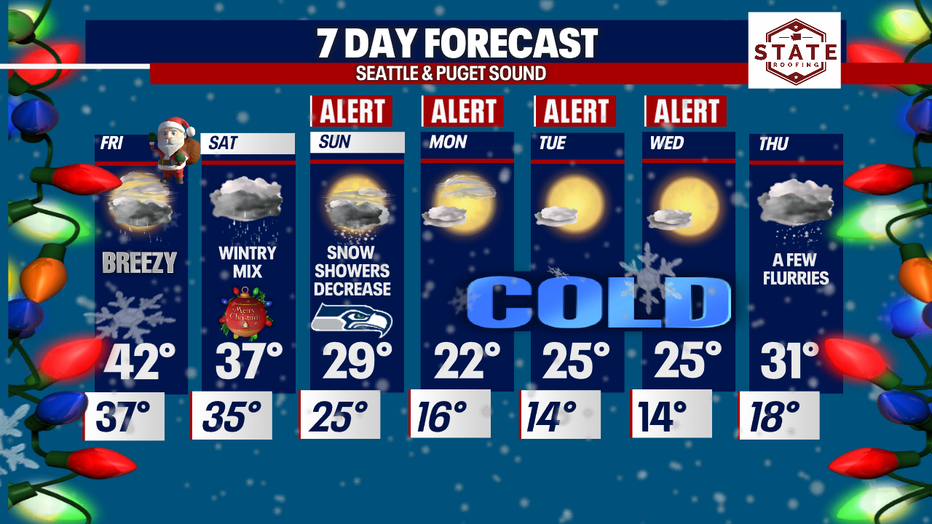
Back to potential for lowland snow! Our weather headlines highlight the loose timing of this winter weather event. If we look at your Christmas forecast, most all of us could see snowflakes flying at some point Saturday into early Sunday. The best shot for accumulating snow... along the coast, through the Strait and North Sound.
Please allow for extra time when driving around this holiday weekend. Roads that were wet from rain and a chunky rain/snow mix will freeze making for slick conditions, especially the second half of the weekend.
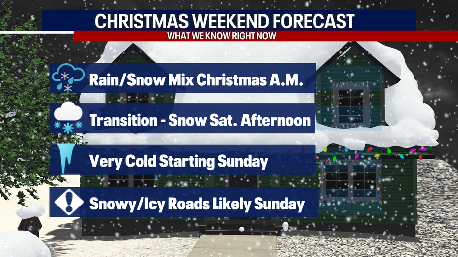
This forecast all thanks to a quick moving system tracking across the Northern Olympics Friday bringing showers to most of the area. This weather maker will help activate Fraser River outflow pulling down a very cold air-mass into WA. Snow levels will start to drop as well giving the chance for lowland snow starting as early as Saturday morning. Whatcom County will see cold enough temperatures to pull down snow. This all depends on the exact timing of the intensity of the Fraser outflow. With that said folks near Bellingham may wake up to a little snow on Christmas morning. For the rest of us we'll see rain and a rain/snow mix.
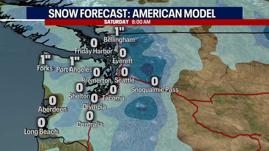
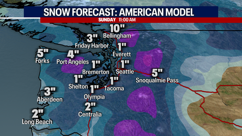
By late Saturday into Sunday totals will pick up for Whatcom and San Juan Counties along with the Strait and coast. Almost everyone else seeing trace to a couple of inches of snow. This will make driving tricky at times for holiday drivers. Allow for extra travel time.
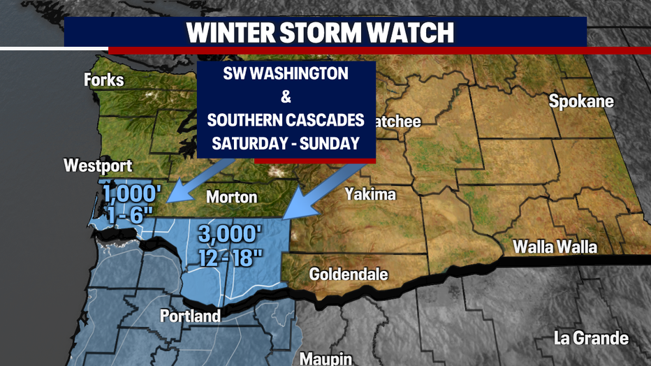
As we continue to see snow levels dropping a "Winter Storm Watch" goes into effect Saturday into Sunday for the SW WA coast and the southern Cascades.
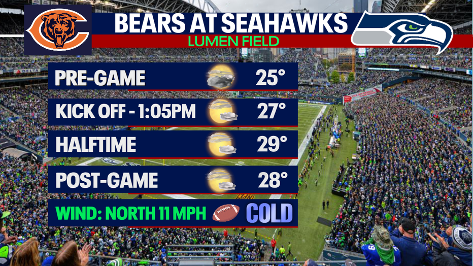
If you're heading out to Lumen Field Sunday for the Seahawks vs Bears match up you better bundle up because the stadium will be cold! Winds will be breezy at times out of the north at 10-14 mph. Pre-game goers may see a few snowflakes flying otherwise expect a mostly dry day. Highs for Sunday only forecast near 30! he best seat might be at home watching the game on FOX 13! #GoHawks
Once we push past Sunday, we nosedive into the bitter cold zone! Check out high temperatures Monday… only climbing into the low 20s with overnights in the mid-teens. We haven't seen these cold temperatures for a long time.
With this "Arctic Blast" across the region we may see frozen pipes. Make sure to cover those outdoor spickets if they are not frost/freeze proof.
Happy holidays all! ~Erin Mayovsky, FOX 13 Forecaster