

Weather Alert for Sunday! Rain, wind, and heavy mountain snow will make for tricky travel to start 2022

The big thaw starts Sunday!
We've been buried in snow for a little over a week, but starting Sunday, temperatures will finally warm up and start melting it all away!
SEATTLE - After eight days of frigid winter weather and snow, Western Washington will start to thaw out Sunday with rain and warmer temperatures.

FOX 13 has issued a "Weather Alert" for tomorrow due to gusty winds on the coast and northwest interior. Winds will start picking up tonight and could gust up to 50-55 mph in those spots. We will also see heavy rain at times Sunday evening and some probable urban flooding due to clogged drains by ice and snow.


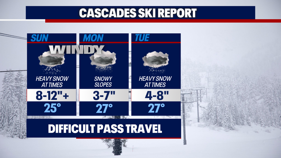
Heavy rain in the lowlands will also mean heavy snow in the mountains. Two to three feet of new snow is expected through Tuesday.


You may have seen some online chatter about the possibility for more lowland snow Monday and Tuesday. Snow levels should stay in the 500-1,000 foot range early next week. It would take some heavier precipitation to send snow levels to the surface and to get some accumulation. I don't see that happening right now, but the possibility is still there of a rain and snow mix each morning through Wednesday.
Things can change quickly, so make sure to stay tuned to the forecast over the coming days. Enjoy the warmer weather and the rain!

MORE FROM FOX 13 WEATHER:
DOWNLOAD: FOX 13 Weather and News Apps
WATCH: Forecast and Radar
READ: Closures and Delays
CHECK: Latest Weather Alerts and Live Traffic Map
INTERACT: Submit your Weather Photo
DAILY BRIEF: Sign Up For Our Newsletter
FOLLOW: Lisa Villegas, Erin Mayovsky, Brian MacMillan, Abby Acone and Scott Sistek
Watch FOX 13 Seattle for the latest news: