

Seattle weather: More showers through Friday, snow in the Cascades
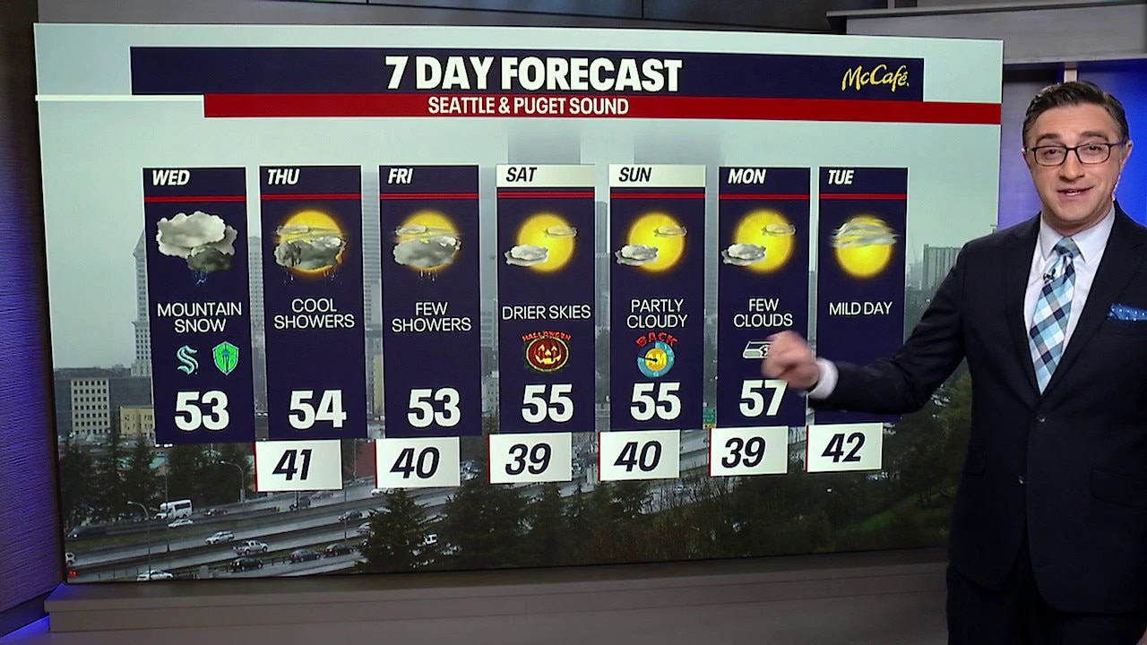
Seattle weather: Cool and showery, with some mountain snow
A lingering low-pressure system will keep Western Washington cool and showery through Thursday, bringing periods of heavier rain and breezy conditions Tuesday night.
SEATTLE - Showers will stick around across Western Washington for the next couple of days as an area of low pressure spins near Vancouver Island and slowly drifts toward the Washington coast.
Wednesday will be another cool, unsettled day, with highs in the low- to mid-50s. Showers will rotate through the region throughout the day, and there could even be a few thunderstorms late this afternoon.
Wednesday night will be cool with scattered showers and cool overnight lows.
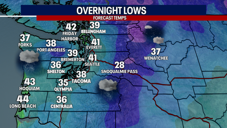
Thursday morning will bring showers to Seattle with chilly overnight lows. (FOX 13 Seattle)
First 5pm sunset of the season
Big picture view:
Wednesday night also brings its first 5:00 p.m. sunset of the season, with 4:00 PM sunsets right around the corner on Sunday.
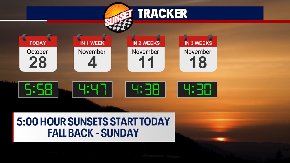
The first 5:00 hour sunset of the season is tonight. (FOX 13 Seattle)
Not much changes on Thursday and Friday. The low will continue moving south, keeping shower chances in the forecast. Temperatures will remain on the cool side, with highs in the low to mid 50s.
Mountain snow in the Cascades
By the numbers:
The first snow of the season is falling at Snoqualmie Pass. This is right around the average time we see Snoqualmie Pass's first snow.
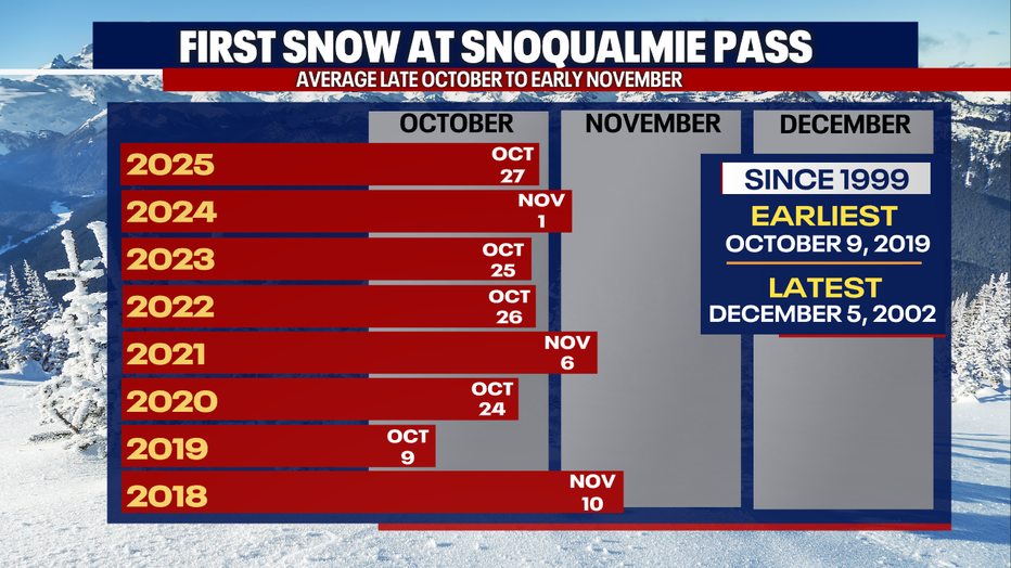
Snoqualmie Pass saw its first snow of the season on Wednesday. (FOX 13 Seattle)
Winter weather continues in the Cascades, where accumulating snow is expected at higher elevations through Wednesday and lighter amounts are possible over the next couple of days.
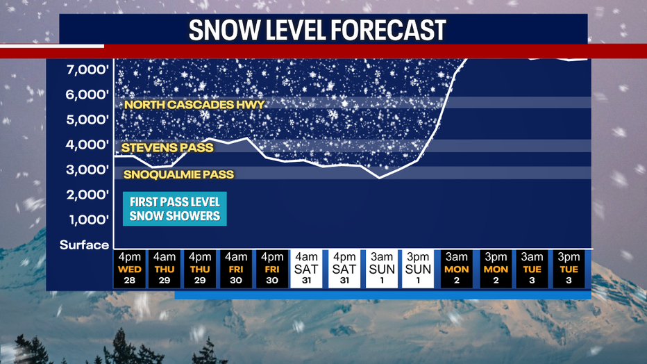
Snow levels will remain at around 4,000 feet through Friday, bringing a few more inches of snow to the mountain passes. (FOX 13 Seattle)
The Winter Weather Advisory for the Cascades remains in effect until 5 p.m. Wednesday. Snow levels are hovering around 3,000 to 3,500 feet, allowing snow to accumulate at the mountain passes and higher elevations.
If you're heading over the passes, check the latest road conditions and be prepared for snow and changing travel conditions.
Drier Halloweekend in Seattle
What's next:
Shower chances will decrease Friday night into Saturday as the low weakens and moves inland. Saturday and Sunday look partly cloudy and mainly dry. Trick or Treating time will be cool for the kids, but it will be dry.
Monday and Tuesday could bring some morning fog with partly sunny afternoons and warmer high temperatures, in the mid to upper 50s.
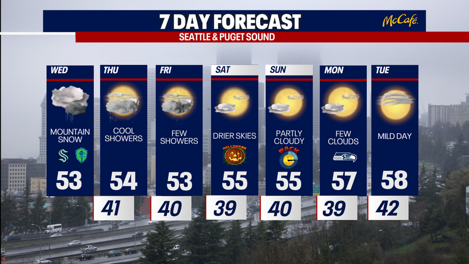
Showers will end Friday, leading to a drier Halloween weekend in Seattle. (FOX 13 Seattle)
MORE NEWS FROM FOX 13 SEATTLE
Feds ask WA to set aside 400 ballots from suspected noncitizens
Woman hospitalized after bear attacks her near home in Index, WA
WA early voting turnout hits 15%, surpassing 2022 midterm pace
Bremerton Foodline facing severe shortages as demand surges by 55%
Teen rearrested after Rochester High School football threat
To get the best local news, weather and sports in Seattle for free, sign up for the daily FOX Seattle Newsletter.
Download the free FOX LOCAL app for mobile in the Apple App Store or Google Play Store for live Seattle news, top stories, weather updates and more local and national news.
The Source: Information in this story comes from weather models interpreted by the FOX 13 Seattle weather team.