

Nakia Creek Fire: 1,796 acres burned east of Vancouver, 5% contained

Nakia Creek Fire burns 2,000 acres
The Nakia Creek Fire has broken through containment lines and it has burned 2,000 acres.
CLARK COUNTY, Wash. - The Nakia Creek Fire burning east of Vancouver has forced evacuation orders as it has burned 1,796 acres. Fire officials say it is around 5% contained.
Fed by gusty winds and low humidity, the growth of the fire prompted authorities to order evacuations as the blaze sent up a plume of white smoke visible throughout the Portland metropolitan area.
Residents of an estimated 1,000 homes were under evacuation orders, Rodruck said. The state issued a mobilization order allowing any firefighting agency to dispatch resources to the blaze, he said.
The Clark Emergency Services Agency expanded evacuation zones into the rural outskirts of the cities of Camas and Washougal, The Columbian reported.
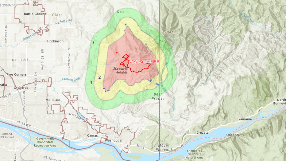
Map of evacuation orders for the Nakia Creek Fire (Esri, CGIAR, USGS)
"Please understand that this is a very dynamic situation and if you are anywhere near this area, you should take precautions to evacuate," the emergency services agency said in a statement.
Crews had secured a perimeter containing 20% of the fire burning in the Larch Block of the Yacolt Burn State Forest. The National Weather Service had posted a red flag warning for wind and low humidity in the region, including the south Washington Cascades, with wind gusts up to 30 miles per hour for Sunday.
A shelter for evacuees was opened at a church in Camas.
About 100 personnel, supported by water-dropping helicopters, were battling the fire, which began Oct. 9.
READ MORE: High wildfire risk forecast for this weekend around Cascades
Get breaking news alerts in the FREE FOX 13 Seattle app. Download for Apple iOS or Android. And sign up for BREAKING NEWS emails delivered straight to your inbox.
The Associated Press contributed to this report.