

Watch: Lee's monstrous eyewall captured by Hurricane Hunters in electric video

Hurricane Hunters fly into monster Hurricane Lee
Hurricane Lee could remain a Category 4 or Category 5 storm for another week. The path of the storm's center is still uncertain, making Hurricane Hunter data critically important in the hours and days ahead. Hurricane Hunter Lt. Col. Mark Withee, navigator for the 53rd Weather Reconnaissance Squadron joins FOX Weather from St. Croix, one of the U.S. Virgin Islands in the Caribbean.
The U.S. Air Force's Hurricane Hunters are giving us a front-row seat to the awe and fury of monstrous Category 5 Hurricane Lee.
On Thursday night, the Air Force Reserve 53rd Weather Reconnaissance Squadron flew into Lee's eyewall during its period of rapid intensification, unsure of the storm's strength.
"We knew it was going to be strong and further developing, but we didn't know that it was going to be a Category 5," said Hurricane Hunter Lt. Col. Mark Withee, the navigator who flew into the center of the hurricane, an experience few people on Earth can relate to.
INSIDE THE FLYING LABORATORY USED BY NOAA'S HURRICANE HUNTERS
Yet a Category 5 storm is exactly what his team found when they flew into the storm and made four passes through the eyewall, Withee told FOX Weather.
"Obviously, there was a lot of convection and lightning going on last night, but we managed to get down safely," he added.

Hurricane Hunters capture Hurricane Lee's eye during rapid intensification
Air Force Reserve 53rd Weather Reconnaissance Squadron’s Hurricane Hunters took a flight Thursday night inside the eye of Category 5 Hurricane Lee.
Crew witnesses Hurricane Lee's ‘stadium effect’
The Air Force Reserve 53rd Weather Reconnaissance Squadron’s aircraft was able to document the powerful storm, measuring a peak wind speed of 165 mph. It was an explosion in intensity from 80 mph just the night before.
Hurricane Hunters fly into tropical systems to gather atmospheric data for accurate weather models, NOAA said. They locate the center of the storm to determine direction, speed, pressure, and intensity, which improves forecasting.
HOW ‘KERMIT’, ‘MISS PIGGY’, AND ‘GONZO’ HUNT DOWN HURRICANES
On this flight, the crew observed the "stadium effect" in the eye of Hurricane Lee, which is a phenomenon that occurs in highly intense hurricanes, according to NOAA. The layers of towering eye wall clouds amid the clear center gives the feel of being in the middle of a stadium.
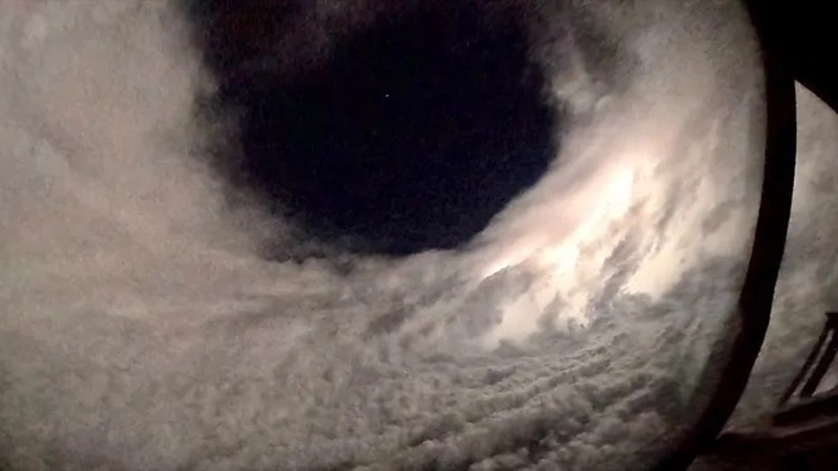
Hurricane Hunters observed the stadium effect within the eye of Hurricane Lee.(Hurricane Hunters)
When flying into Lee Thursday, Withee noted the absence of moonlight, requiring crews to rely solely on radar for guidance in the darkness.
"But then once we were in the eye of the storm, then it was mostly dark, except for the repeated lightning that would flash up and illuminate, so we could see it beyond just what the radar picture was showing," he said.
As they navigated through the eyewall, Withee said they carefully search for any potential dangers. Meanwhile, the weather officer in the back of the aircraft uses their instruments to direct the aircraft towards the center of the storm with the lowest pressure and circulation.
HURRICANE LEE LIVE TRACKER: SATELLITES SPAGHETTI COMPUTER MODELS, CONE OF CONCERN AND MORE
Withee said his crew is expected to be taking off again at 5 a.m. Saturday to track the progress of Lee. The storm is currently forecast to move far north of the northern Leeward Islands, the Virgin Islands, and Puerto Rico during the upcoming weekend and early next week. But its potential path for East Coast impacts remains uncertain.
Meanwhile, swells from Lee will hit the Lesser Antilles on Friday and the Virgin Islands, Puerto Rico, Hispaniola, Turks and Caicos Islands, Bahamas and Bermuda this weekend.
These swells are likely to cause life-threatening surf and rip current conditions, the National Hurricane Center warns. Dangerous surf and rip currents are expected to begin along most of the U.S. East Coast beginning Sunday.