


Mostly sunny skies with warmer highs Thursday
We'll warm to near average Thursday with even warmer temps as we sail into the weekend and next week.
We'll warm to near average Thursday with even warmer temps as we sail into the weekend and next week.


Seattle weather: Mostly sunny skies with warmer highs Thursday
One more day of cooler than average highs before we warm back to normal and above. Next week the 80s return!
One more day of cooler than average highs before we warm back to normal and above. Next week the 80s return!


Temps warming up into the weekend
Temperature will stay in the low 70s to end the week out before getting up to 80 again next week.
Temperature will stay in the low 70s to end the week out before getting up to 80 again next week.


20th driest May so far in Seattle
20th driest May so far in Seattle
20th driest May so far in Seattle


Cooler temps with filtered sunshine
Onshore flow will remain with us through Thursday this week keeping us a little cooler with filtered sunshine.
Onshore flow will remain with us through Thursday this week keeping us a little cooler with filtered sunshine.


Seattle weather: A cool Wednesday, but warmer into the end of the week
One more cooler than average day ahead of another warm up.
One more cooler than average day ahead of another warm up.

Lots of sunshine in our forecast this week!
FOX 13 Forecaster Erin Mayovsky is tracking a week of sunshine and pleasant temps!
FOX 13 Forecaster Erin Mayovsky is tracking a week of sunshine and pleasant temps!


Seattle weather: Early morning clouds in the mid-60s
Seattle weather: Early morning clouds in the mid-60s
Seattle weather: Early morning clouds in the mid-60s


Cool and cloudy to start of the week
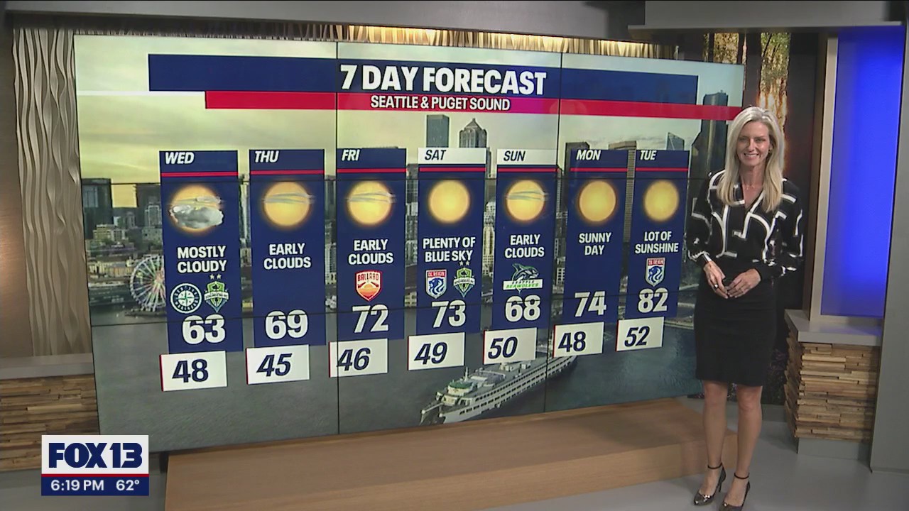
Temps will be in the mid to upper 60s until Friday when we start seeing highs in the 70s.
Temps will be in the mid to upper 60s until Friday when we start seeing highs in the 70s.


Gray clouds to start with afternoon sunshine
The familiar pattern of morning clouds and afternoon sunshine lasts through Friday. Saturday will be hotter as temps nudge closer to 80 degrees.
The familiar pattern of morning clouds and afternoon sunshine lasts through Friday. Saturday will be hotter as temps nudge closer to 80 degrees.


Seattle weather: Mild Memorial Day forecast for Western Washington
FOX 13 Meteorologist Abby Acone has pleasant, mild weather in the forecast for Seattle.
FOX 13 Meteorologist Abby Acone has pleasant, mild weather in the forecast for Seattle.


Morning clouds to afternoon sun for the extended outlook
Late night and early morning clouds that give way to afternoon sunshine is the theme for the extended forecast. Highs hang near average.
Late night and early morning clouds that give way to afternoon sunshine is the theme for the extended forecast. Highs hang near average.


Cooler temperatures for Memorial Day weekend
Cooler temperatures for Memorial Day weekend
Cooler temperatures for Memorial Day weekend


Seattle weather: Cooling off as we roll into the holiday weekend
Cooler, but comfortable highs for the holiday weekend!
Cooler, but comfortable highs for the holiday weekend!

Seattle weather: Cooling off as we roll into the holiday weekend
Seattle weather: Cooling off as we roll into the holiday weekend
Seattle weather: Cooling off as we roll into the holiday weekend


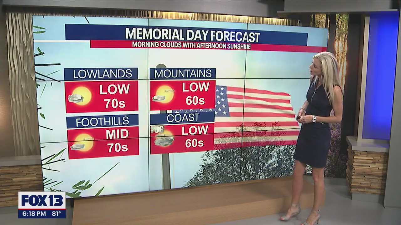
Warm start to Memorial Day weekend
Fog lifts quickly Friday morning leading to plenty of blue sky for Western Washington. Highs Friday will again run well above normal, landing in the 70s & low 80s.
Fog lifts quickly Friday morning leading to plenty of blue sky for Western Washington. Highs Friday will again run well above normal, landing in the 70s & low 80s.

Seattle weather: Heating up Friday, but cooling off some for the holiday weekend
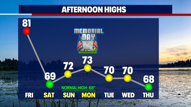
Highs continue to warm well above average into Friday with cooler mariner air flowing back into Western WA for the holiday weekend.
Highs continue to warm well above average into Friday with cooler mariner air flowing back into Western WA for the holiday weekend.


Seattle weather: Heating up Friday, but cooling off some for the holiday weekend
Seattle weather: Heating up Friday, but cooling off some for the holiday weekend
Seattle weather: Heating up Friday, but cooling off some for the holiday weekend


Plenty of sunshine with temps in the 70s
This holiday weekend is action packed with sports. Look for morning clouds to give way to sunshine with highs in the upper 60s to low 70s.
This holiday weekend is action packed with sports. Look for morning clouds to give way to sunshine with highs in the upper 60s to low 70s.


Temperatures climb to 80 by Friday, brief cooldown this weekend
Temperatures climb to 80 by Friday, brief cooldown this weekend
Temperatures climb to 80 by Friday, brief cooldown this weekend