

Intense mountain snow ahead with dark, rainy weather for Seattle
Seattle weather: Snowy weather for high elevations, coastal flooding possible
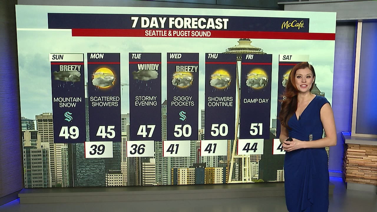
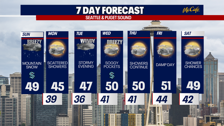
FOX 13 Meteorologist Abby Acone has your 7-day forecast.
SEATTLE - Buckle up for rounds of lowland rain and mountain snow to impact driving conditions and ski resorts this week
We’ve already hit our high temperatures for the day today. Earlier Sunday morning, temperatures maxed out in the upper 40s to low 50s. Western Washington will hover in the mid 40s throughout the rest of the afternoon.
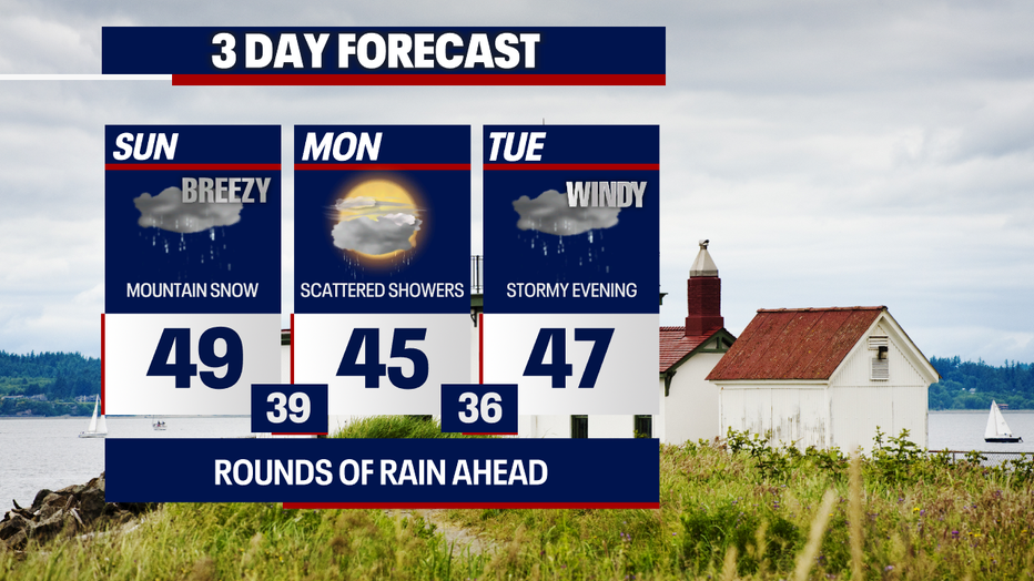
Highs will reach the 40s the next three days in Seattle. (FOX 13 Seattle)
You can plan on scattered rain with isolated thunderstorms and small hail. The skies will be primarily dark with breezy conditions, too.
This weekend, we’ve closely tracked king tides around the region. Earlier today, we watched for minor coastal flooding in Puget Sound.
Monday morning, there’s another chance for minor coastal flooding in Puget Sound along shorelines and other low-lying coastal areas around high tide. Today along the far Washington coast, there’s a chance for significant coastal flooding.
King tides aren’t a scientific term: it’s used to describe some of the highest tides of the year which occur in November, December and January.
Flooding happens when there is low atmospheric pressure, heavy rains and wind when high tides occur. Thankfully, we’re not expecting flooding to be as bad as what the South Park Seattle neighborhood endured two years ago.
Here's a website with more information on king tides.
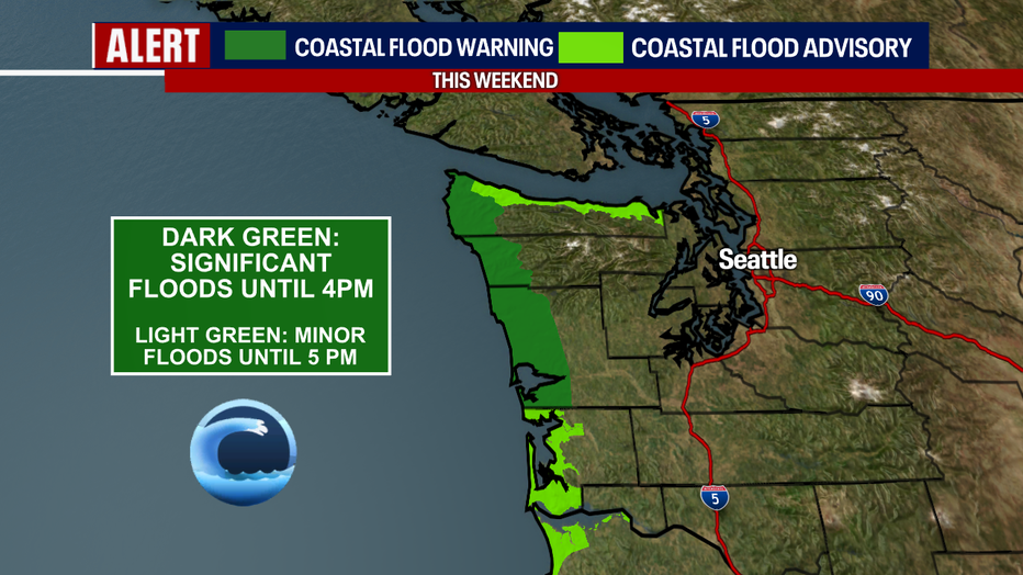
Minor coastal flooding is expected in Puget Sound again Monday morning. (FOX 13 Seattle)
Over the mountains, conditions will be rapidly deteriorating through Monday morning as snow fires up in a big way. In general, we’re predicting between one and two feet of snow to pile up over the Cascade passes.
Make sure you and your car are prepared for winter traveling: bring chains just in case it’s required. Check WSDOT conditions for any restrictions before driving over the higher elevations. A Winter Storm Warning continues until 10 a.m. Monday.
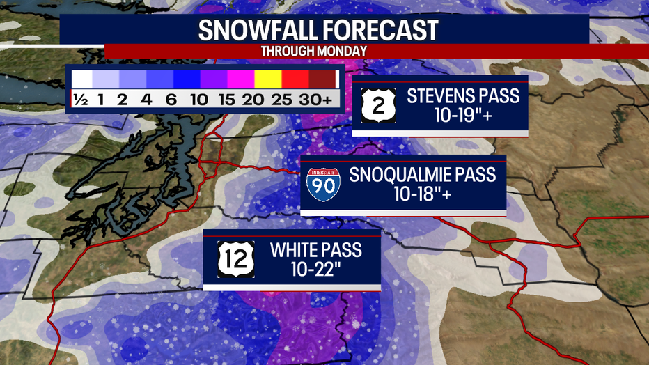
Heavy snow is on the way for the Cascade mountains Sunday into Monday morning. (FOX 13 Seattle)
Tomorrow, scattered rain and thunderstorms are possible once again. Otherwise, it’ll be a fairly quiet evening on Monday.
On Tuesday, an area of low pressure in the Pacific Ocean will be strengthening rapidly – becoming what’s called a "bomb cyclone." This is a fancy meteorological term to describe a low pressure system that intensifies quickly – dropping 24 millibars in pressure in 24 hours or less.
This area of low pressure will do that and more; however, we’re not expecting it to make landfall here in Western Washington (we’ll let you know if that changes).
Currently, it seems like the biggest threat from this storm is the potential for damaging winds from the east in the Cascade "gap" communities (e.g. North Bend, Enumclaw, Black Diamond and Gold Bar) Tuesday – especially in the evening. It could be windy elsewhere with lowland rain and mountain snow, but there’s still time for this forecast to change and evolve. Stick with us as we watch the latest!
Buckle up for rounds of lowland rain and mountain snow this week. (FOX 13 Seattle)
Take good care,
Meteorologist Abby Acone