

Seattle hits first 70-degree day of 2026; weather cools down this week
Seattle Weather: First 70 degree day hits the Puget Sound area
Seattle Weather: First 70 degree day hits the Puget Sound area
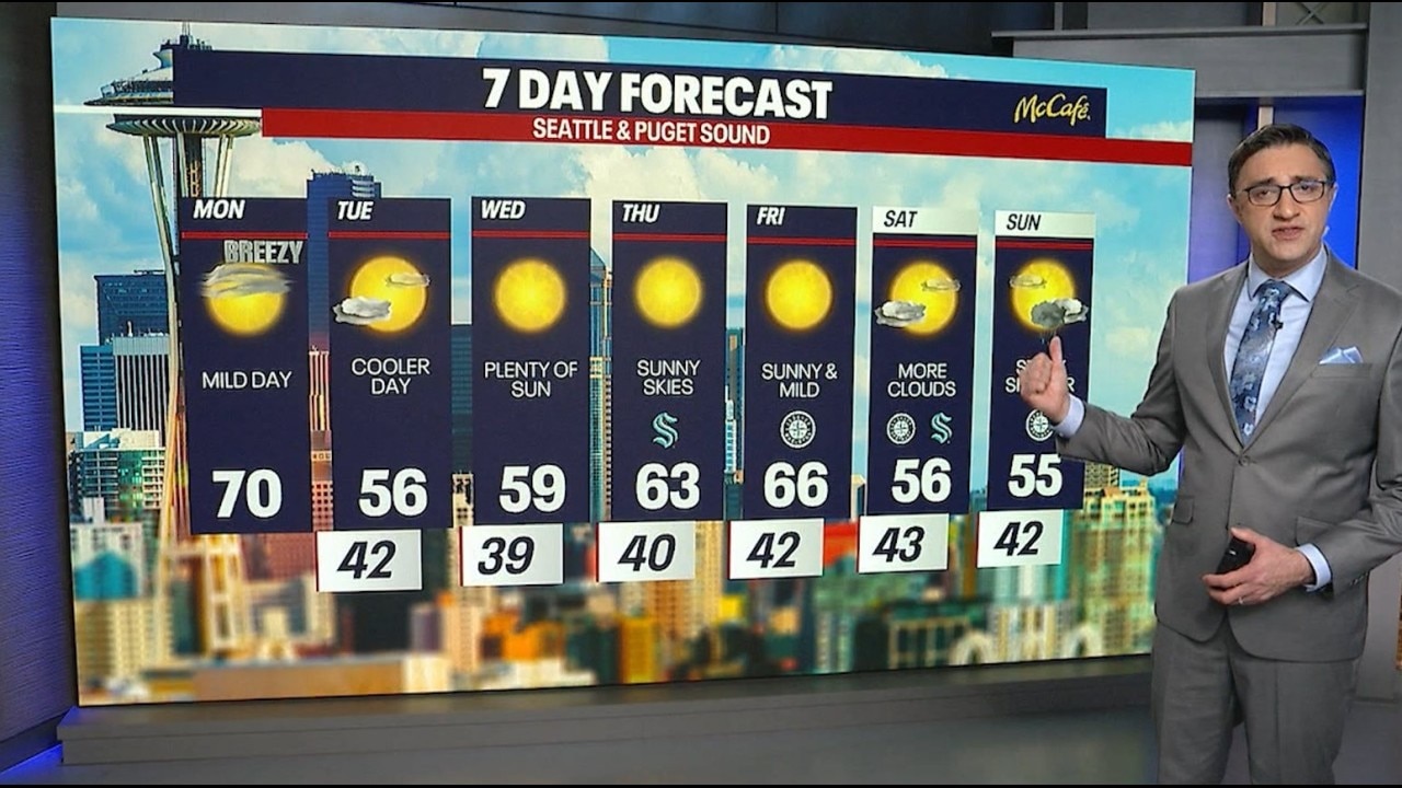
SEATTLE - After a spectacular, warm Monday afternoon, changes are underway this evening across Western Washington.
A ridge of high pressure that has been keeping Western Washington warmer and sunnier is sliding out. We will transition to a cooler, more seasonable pattern.
On the coast, the switch to onshore flow is already being felt. Clouds will gradually increase later this evening as marine air begins to push inland. Tonight is when things really shift. A strong marine push will develop, bringing increasing clouds and a noticeable breeze.

Onshore flow will bring in a much cooler airmass late Monday night. (FOX 13 Seattle)
Cooler week ahead in western WA
Big picture view:
Expect westerly winds funneling through the Strait of Juan de Fuca, with breezy conditions extending into parts of the South Sound and southwest interior. Overnight lows will dip into the mid 30s to low 40s.

Increasing cloud cover will develop in Western Washington Monday night. (FOX 13 Seattle)
Tuesday brings a cooler feel across the entire region. Even with some sunshine returning, temperatures will struggle to reach the upper 50s for most inland areas, with the mid 50s along the coast.

Clouds will roll in on Tuesday morning in Western Washington. (FOX 13 Seattle)
What's next:
By Wednesday morning, clear skies and light winds will allow temperatures to drop even further. Some of the colder spots in the South Sound and southwest interior could flirt with freezing, while most locations wake up in the 30s. Afternoon highs rebound slightly into the mid 50s to low 60s under mostly sunny skies.
The overall pattern stays pretty quiet through the end of the workweek. Dry northwesterly flow aloft will keep conditions stable, with a gradual warming trend pushing highs back into the 60s by Thursday and Friday. Mornings will still be crisp, though, so keep the jacket handy early in the day.
Looking ahead to the weekend, the pattern turns more active again. A cool upper-level low dropping in from the Gulf of Alaska will bring back clouds, showers, and cooler temperatures. Highs will fall back into the 50s Saturday and Sunday, with a return to that classic springtime mix of sunbreaks and passing showers.

It will be a quiet weather week in Seattle with plenty of sunshine. (FOX 13 Seattle)
MORE NEWS FROM FOX 13 SEATTLE
7 teens involved in deadly Bremerton car crash
Controversy continues to surround CCTV cameras in Seattle
Drivers navigate delays as WSDOT works to clear Bellingham, WA landslide
Budget cuts could impact access to Washington’s public lands
WA judge gives man longest big game sentence in decade for elk killing spree
To get the best local news, weather and sports in Seattle for free, sign up for the daily FOX Seattle Newsletter.
Download the free FOX LOCAL app for mobile in the Apple App Store or Google Play Store for live Seattle news, top stories, weather updates and more local and national news.
The Source: Information in this story comes from weather models interpreted by the FOX 13 Seattle weather team.