

Seattle weather: Sunshine returns for the workweek, cooldown Seafair weekend
Driest day of the year in Seattle
FOX 13 Seattle Chief Meteorologist Brian MacMillan has your 7-day forecast.
SEATTLE - After a beautiful Wednesday afternoon, western Washington will settle into more summer sunshine for the rest of the workweek.
High pressure will continue to strengthen over the region through Friday, bringing dry conditions and gradually warmer temperatures that will peak at the end of the week.
On average, July 29 is the driest day of the year in Seattle. Seattle-Tacoma International Airport has seen measurable rain on this date only five times since 1945.
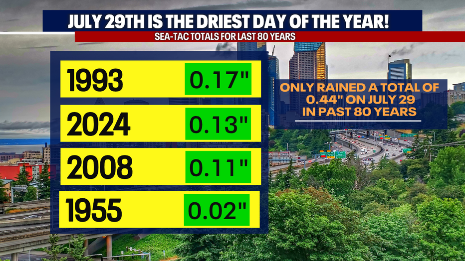
July 29 is the driest day of the year in Seattle on average. (FOX 13 Seattle)
Dryest day of the year, warmest day of the week
High temperatures will climb into the 70s on Thursday. Many inland areas will reach the low 80s on Friday, making it the warmest day of the week. Overnight lows will remain comfortably cool, helping limit the risk of heat-related illnesses despite the warmer afternoons.
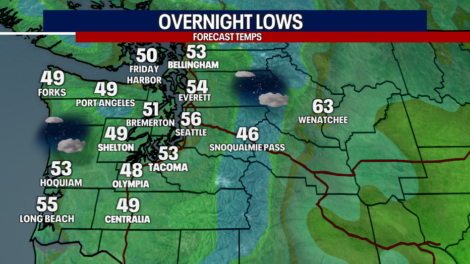
It will be cooler with partly cloudy skies early Thursday morning in Western Washington. (FOX 13 Seattle)
Cooler and cloudier Seafair Weekend
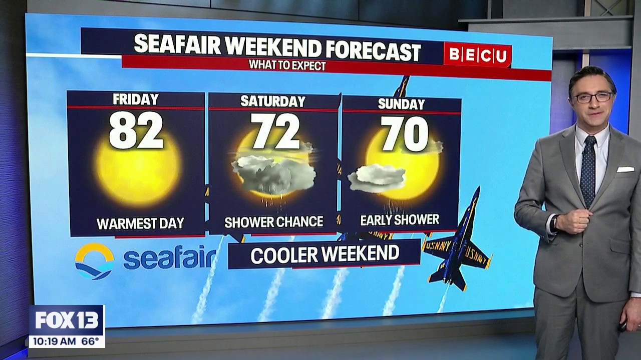
A weather system will move inland late Friday and into Saturday, bringing a noticeable change for Seafair weekend.
Expect increasing clouds Friday night followed by cooler temperatures on Saturday. There will also be a chance of scattered showers, with the best opportunity along the coast and the Olympic Peninsula. A few showers could also develop around central Puget Sound if a Puget Sound convergence zone sets up behind the front.
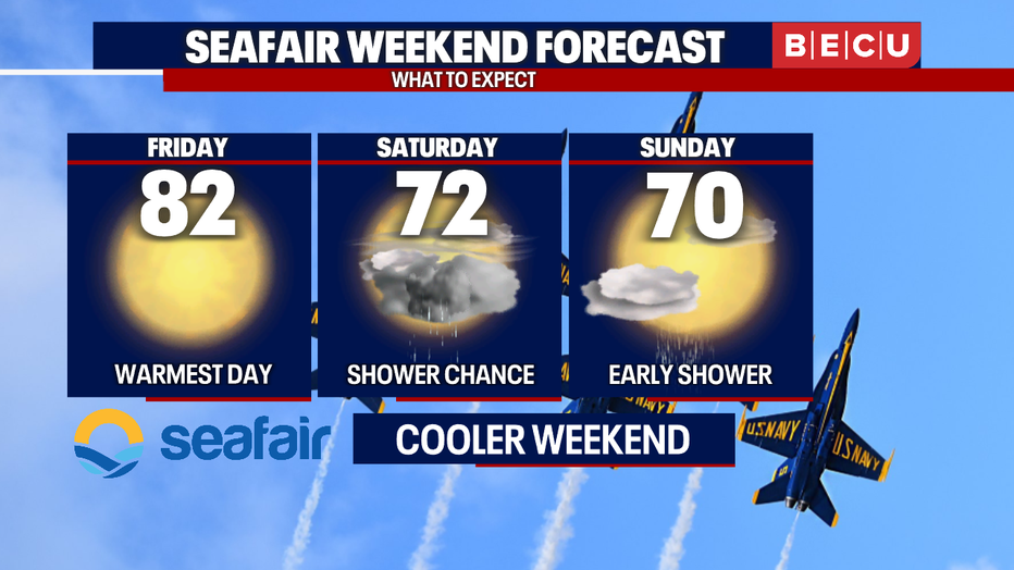
It will be cooler and cloudier over the weekend for Seafair in Seattle. (FOX 13 Seattle)
The cooler weather won’t last long. High pressure rebuilds early next week, bringing sunshine and warmer temperatures back to the Pacific Northwest.
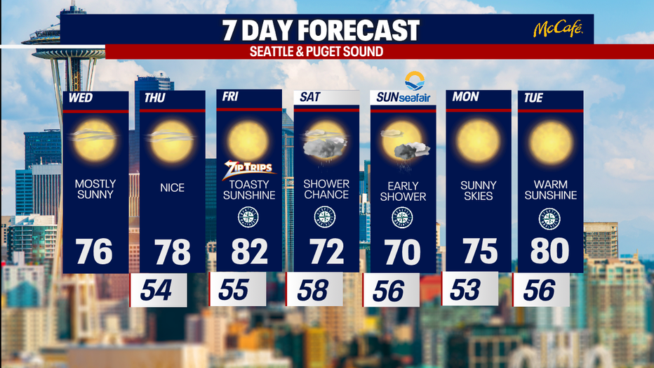
Temperatures will remain close to average with mainly dry conditions in Seattle this week. (FOX 13 Seattle)
Wildfire Outlook: Central & Eastern Washington
Wildfire risk will be elevated in central and eastern Washington through the weekend.
Through Friday, warm temperatures, dry air and little to no rainfall will keep vegetation dry. Any existing fires could spread more easily during the afternoon and evening hours, particularly where breezy conditions develop.
The arrival of a weather system this weekend may bring some localized relief. However, precipitation is expected to be spotty, and many locations east of the Cascades may remain completely dry. Fire danger is likely to remain elevated despite the brief cooldown.
If you're spending time outdoors east of the Cascades over the next few days, use extra caution with anything that could create a spark. Small fires can grow quickly under these dry summer conditions.
MORE NEWS FROM FOX 13 SEATTLE
Who was Junior Cee Niko Semo? One of the Bite of Seattle shooters
When to watch the Blue Angels fly at Seattle Seafair 2026
Seafair details new security as Seattle mourns deadly shooting
Seattle police Chief Shon Barnes downplays viral reporter clash
Bite of Seattle shooting: Police recover 'ghost gun', Glock 45, more
Tacoma, WA man pleads not guilty in toddler shooting
Why did it take hours for a press conference on the Bite of Seattle shooting?
Here's where fires in Washington state are burning
To get the best local news, weather and sports in Seattle for free, sign up for the daily FOX Seattle Newsletter.
Download the free FOX LOCAL app for mobile in the Apple App Store or Google Play Store for live Seattle news, top stories, weather updates and more local and national news.
The Source: Information in this story comes from weather models interpreted by the FOX 13 Seattle weather team.