

Seattle weather: Warm Wednesday, storm chance Thursday
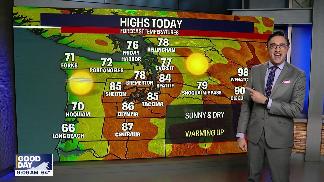
Warm with a chance for thunderstorms in Seattle
FOX 13 Seattle Chief Meteorologist Brian MacMillan has your 7-day forecast.
SEATTLE - Warm midsummer weather will continue to shine over the Pacific Northwest through Wednesday, but a chance for rain and thunderstorms hits Thursday.
Tonight will be clear, with overnight lows dropping into the mid 50s for the greater Seattle area.
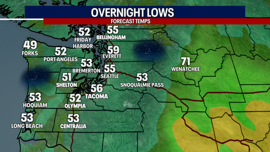
Overnight lows will drop into the 50s Tuesday night in Western Washington. (FOX 13 Seattle)
High pressure will continue to dominate through Wednesday, keeping skies mostly sunny and temperatures running well above average for mid-July, in the mid 80s.
Break from the heat is coming
The forecast takes a turn on Thursday as an upper-level low moves inland. This system should bring a welcome break from the heat, with highs cooling back into the mid 70s to around 80 degrees. It also brings our best chance for measurable rainfall in weeks.
Most of Western Washington will see at least some showers Thursday. The bigger question is how much instability develops during the afternoon. Right now, there is about a 15 to 25 percent chance of thunderstorms, with the highest likelihood over the Cascades and Olympics. While most of the thunderstorm activity should remain focused over the mountains, a few storms could roll off into the nearby valleys. We will be monitoring it closely.
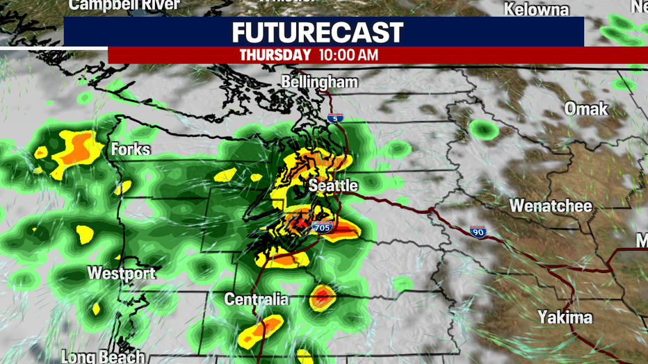
Thursday could bring showers and a chance of thunderstorms to Western Washington. (FOX 13 Seattle)
Thunderstorms could increase wildfire risk
Even though Thursday's system is expected to bring beneficial rainfall to parts of Washington, it also has the potential to increase wildfire concerns heading into the weekend.
The biggest concern is lightning, especially over the Cascades and parts of Central and Eastern Washington where vegetation has been drying out during the recent stretch of warm weather. Thunderstorms can produce cloud-to-ground lightning well away from the heaviest rainfall. That means, some areas could see lightning strikes without enough rain to prevent new fire starts. Thunderstorms can also bring localized gusty winds, which can cause any existing fires to spread more quickly.
A challenge firefighters face with lightning-caused fires is that they aren't always immediately visible. A lightning strike can smolder for hours, or even several days, before developing into a wildfire. Fire crews will be monitoring areas impacted by Thursday's storms for delayed fire starts throughout the weekend.
The timing is especially concerning because a significant warming trend is expected immediately after the storms move through. Temperatures will climb back into the 80s this weekend, with some locations across Western Washington reaching the 90s by early next week. That combination of fresh lightning, dry fuels, hot temperatures, and locally breezy conditions is a recipe for new wildfire starts that can quickly grow.
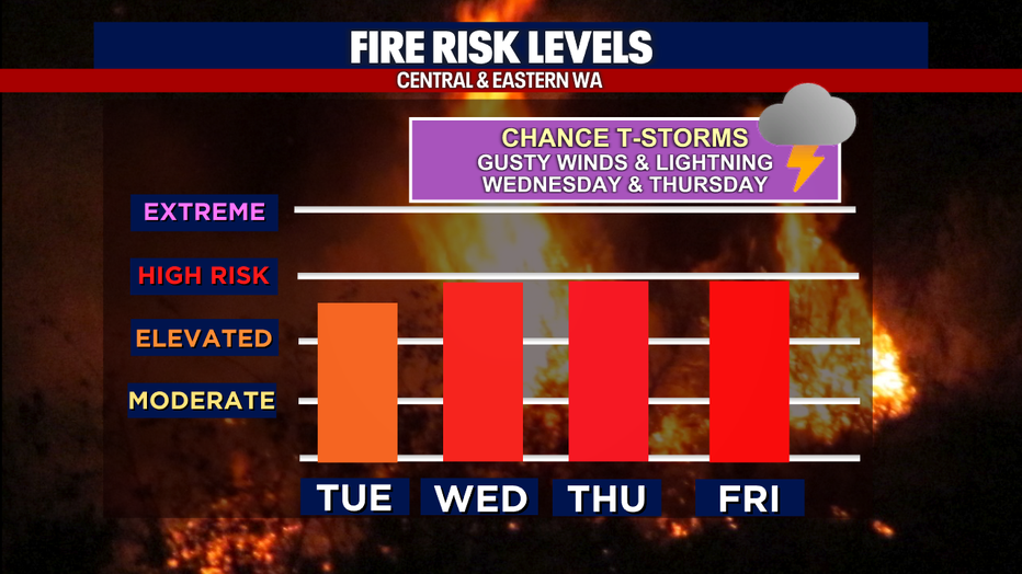
Wildfire danger will be high in Central and Eastern Washington over the next four days. (FOX 13 Seattle)
It's also worth remembering that while lightning can start fires, most wildfires in Washington are caused by people. State officials say roughly 80 to 90 percent of wildfires are human-caused. If you're spending time outdoors this weekend, follow local burn restrictions, use extra caution with equipment that could create sparks, never leave campfires unattended, and avoid any activity that could accidentally ignite dry grass or brush.
Toasty weather returns this weekend
After Thursday's system moves through, any showers will taper off Thursday night, and dry weather quickly returns.
Friday looks nice with early clouds and afternoon highs in the mid 70s to around 80 degrees. High pressure will rebuild over the Pacific Northwest, bringing another warming trend for the weekend.
Highs should return to the upper 70s and lower 80s on Saturday, climb into the low to mid 80s on Sunday, and could reach the mid 80s to near 90 degrees by Monday. Heat risk is expected to increase again by early next week.
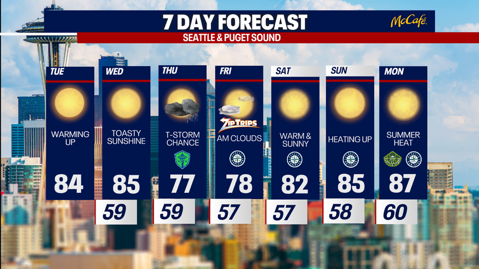
Rain and a chance of thunderstorms returns to the Seattle forecast on Thursday. (FOX 13 Seattle)
MORE NEWS FROM FOX 13 SEATTLE
6-year-old Bellingham, WA boy dies from injuries after beach driftwood accident
Grandmother thwarts Pike Place kidnapping, Seattle police make arrest
'Transfer Fire' near Lake Chelan, WA hospital prompts evacuation notices
Here's where WA wildfires are currently burning
Seattle office vacancy crisis shifts tax burden onto homeowners
Thurston County, WA couple desperate to find dog after Rover sitter vanishes
Husband of pregnant wife killed in Seattle sues King County homeless authority
To get the best local news, weather and sports in Seattle for free, sign up for the daily FOX Seattle Newsletter.
Download the free FOX LOCAL app for mobile in the Apple App Store or Google Play Store for live Seattle news, top stories, weather updates and more local and national news.
The Source: Information in this story comes from weather models interpreted by the FOX 13 Seattle weather team.