

Ongoing WA flooding exposes dangers of Mount St. Helens sediment buildup

Concerns over Mount St. Helens sediment in Cowlitz River
Western Washington leaders are monitoring the Cowlitz River as heavy rain pushes decades-old Mount St. Helens sediment downstream, heightening flood risks.
CASTLE ROCK, Wash. - As steady rain continues to soak western Washington, leaders in Cowlitz County say they are closely monitoring the Cowlitz River amid growing concerns about flooding fueled by volcanic sediment from Mount St. Helens.
Communities downstream from the volcano home to an estimated 90,000 people face ongoing risks as sediment continues to move through the river system, particularly during heavy rain events.
Sediment from Mount St. Helens compounds flood threat
State senators, local mayors and county officials report Mount St. Helens sheds about 5 million cubic yards of material annually. For perspective, that’s enough sediment to fill Lumen Field three times over. During periods of heavy rain, the sediment is pushed farther downstream, increasing flood risks for communities like Castle Rock.
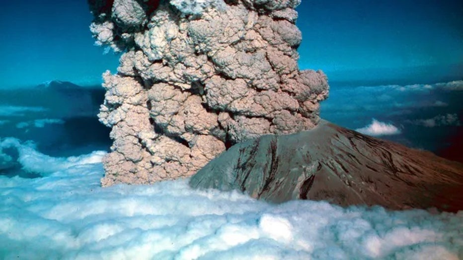
In 1980, a major volcanic eruption occurred at Mount St. Helens, a volcano located in state of Washington, in the United States.. (Photo by: Photo12/Universal Images Group via Getty Images) ( )
What they're saying:
Castle Rock Public Works Director David Vorse said the effects are already visible.
"You see the river being muddy right now, the sediment is accumulating, and when the water goes down, there are huge sandbars that have formed," said Vorse.
He tells FOX 13 sediment buildup is already damaging land along the river.
"It’s taking private and public properties," said Vorse. "It’s literally wiping out acres and acres of public property."
As public works director, he said flooding is not a question of possibility, but timing.
"We always hope that we don’t see these kind of events," said Vorse. "But we know that we are, and it’s not a matter of if, it’s just a matter of when."
Leaders warn of widespread consequences
Roughly one month before the recent flooding, a letter was sent to the commanding general of the U.S. Army Corps of Engineers expressing "deep concern regarding the accelerating sedimentation issues in the Toutle, Cowlitz, and Columbia River systems caused by the continuing activity at Mount St. Helens."
The letter highlighted concerns about levee integrity, expanding sandbars and water quality impacts affecting both humans and wildlife.
"A single above-average event under current conditions could devastate more than 90,000 residents," the letter stated. "Timely action is critical."
The letter was signed by several Republican state legislators, county commissioners and local mayors.
Vorse said the concern extends well beyond Castle Rock.
"If it were to get behind some of these levees, it could affect Kelso, it could affect Longview," he said. "Those are huge concerns."
Measures underway, though leaders say they may not be enough
The Army Corps of Engineers has taken steps to reduce the risk, including building a sediment retention structure on the Toutle River and conducting dredging operations on the Cowlitz River.
However, local leaders say more action is needed.
"This is the only river in the lower 48 states that has a volcano feeding into it that takes this kind of sediment," said Vorse.
Representatives from the Army Corps tell FOX 13, "Along the Cowlitz river, our engineers are actively monitoring sediment data to ensure we maintain a level of protection that will keep communities safe. Current data shows that our safety standards are being met."
What's next:
A spokesperson says they are on track to secure a contract by the end of the month that would raise the sediment retention system near the volcano.
Scientists continue studying decades-old lahars
The excess sediment filling the river system originated from lahars triggered by the 1980 eruption of Mount St. Helens.
Forty-five years later, U.S. Geological Survey scientists continue studying the material.

At the Cascades Volcano Observatory, researchers working alongside robotic equipment are cataloging and tracking rock and tephra samples to better understand how the sediment continues to move.
"Because it happened so many years ago, it’s just old news," said Vorse. "But it’s not. It’s still ongoing."
MORE NEWS FROM FOX 13 SEATTLE
New WA laws in 2026 include higher wages, luxury car tax, plastic bag fee hike
Person dead after driving car onto flooded roadway in Snohomish
Snoqualmie ski resort offering season pass rollover for late year start
'Muddy mess': Pierce County RV park residents continue flood clean-up
Wild Waves Theme Park to shut down in 2026
To get the best local news, weather and sports in Seattle for free, sign up for the daily FOX Seattle Newsletter.
Download the free FOX LOCAL app for mobile in the Apple App Store or Google Play Store for live Seattle news, top stories, weather updates and more local and national news.
The Source: Information in this story came from Castle Rock Public Works, the U.S. Army Corps of Engineers, U.S. Geological Survey and FOX 13 Seattle reporting.