

Seattle weather: Wildfire smoke, heat hit Western Washington
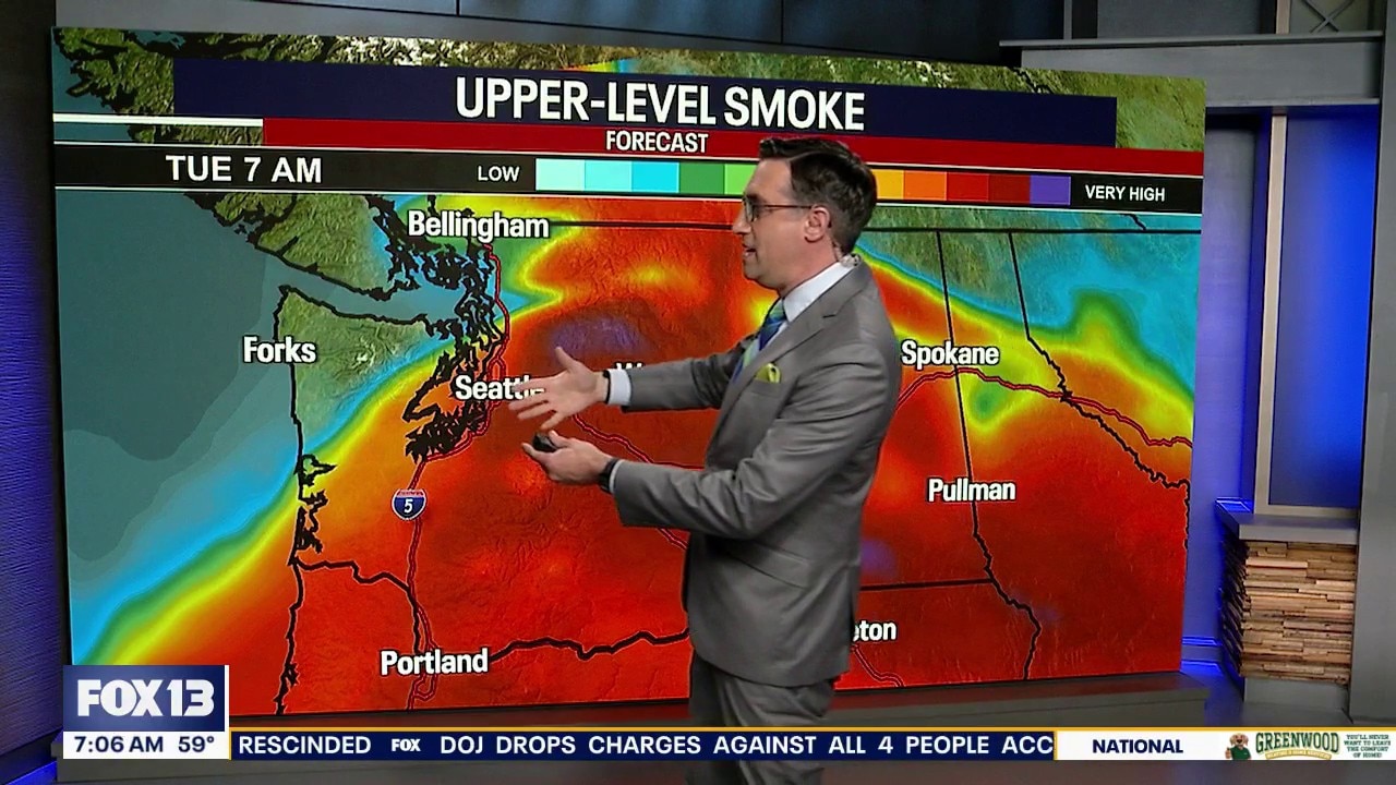
WA air quality: Smoke from wildfires moves into Seattle area
Much of Washington will be blanketed with surface-level smoke from multiple wildfires burning across the state.
SEATTLE - Wildfire smoke will continue to move into Western Washington through at least Wednesday as temperatures climb.
High pressure will continue to strengthen over the Pacific Northwest through midweek, sending temperatures climbing across Western Washington.
Tonight will be hazy and mild, with temperatures dropping to around 60 degrees.
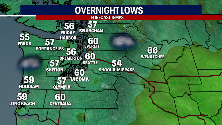
It will be hazy and mild overnight into Wednesday morning. (FOX 13 Seattle)
Offshore winds are pushing smoke west of the Cascades from wildfires burning in Central and Eastern Washington. That means hazy skies and the potential for worsening air quality through at least Wednesday.
Heat builds through Thursday
Wednesday and Thursday will be the hottest days of the week. Afternoon highs will climb into the upper 80s to low 90s across much of the interior, while areas closer to the water stay a little cooler. Overnight temperatures will also remain mild, only falling into the upper 50s and lower 60s through Saturday morning.
If you are going to be outside, stay hydrated, wear lightweight clothing, and take frequent breaks in air-conditioned spaces whenever possible.
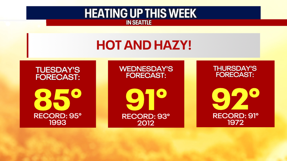
Seattle will be flirting with record high temperatures Wednesday and Thursday. (FOX 13 Seattle)
Smoke and air quality concerns for Western Washington
Smoke will likely become more noticeable across Western Washington through Wednesday as offshore winds send wildfire smoke across the Cascades. Exactly where the thickest smoke settles will vary from day to day, but some of that smoke is expected to mix down to the surface during afternoons. Air quality could reach unhealthy levels in spots.
Air quality conditions should begin improving later this week as winds gradually shift back onshore, helping push cleaner marine air into Western Washington.
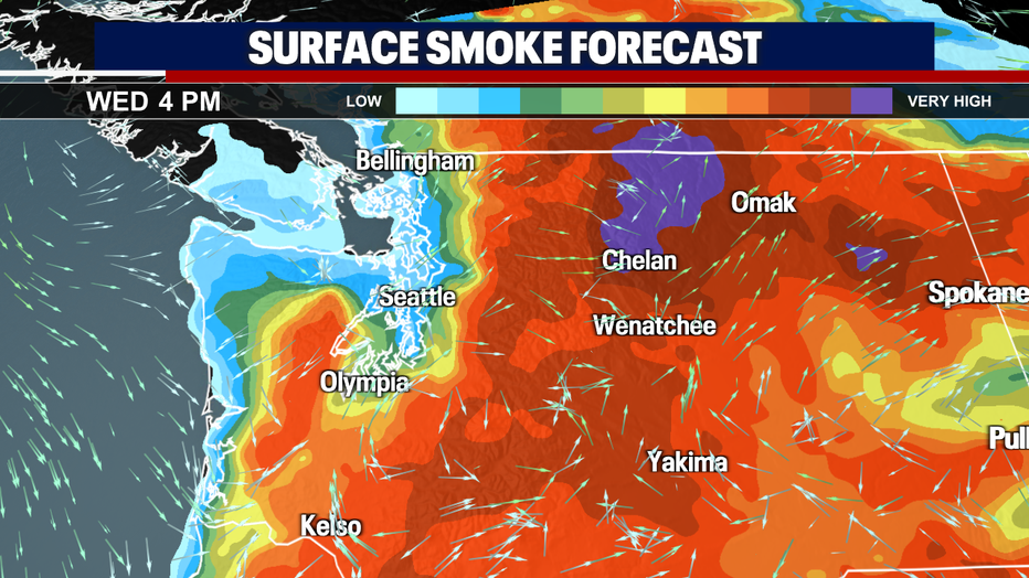
Surface level smoke will impact air quality through at least Wednesday in Western Washington. (FOX 13 Seattle)
Wildfire and air quality outlook for Central and Eastern Washington
Central and Eastern Washington will continue to experience hot, dry weather through midweek.
Air quality across Central and Eastern Washington is expected to remain the worst near active fires, with some communities experiencing unhealthy or very unhealthy conditions at times depending on wind direction.
Looking ahead
The ridge of high pressure begins to weaken and shift east later Thursday, allowing temperatures to gradually drop heading into the weekend.
Highs will return to the upper 70s and lower 80s for most inland communities by Saturday, while overnight lows cool back into the 50s. Expect a few more clouds and a return to onshore flow, which should help clear out lingering smoke and improve air quality for the weekend.
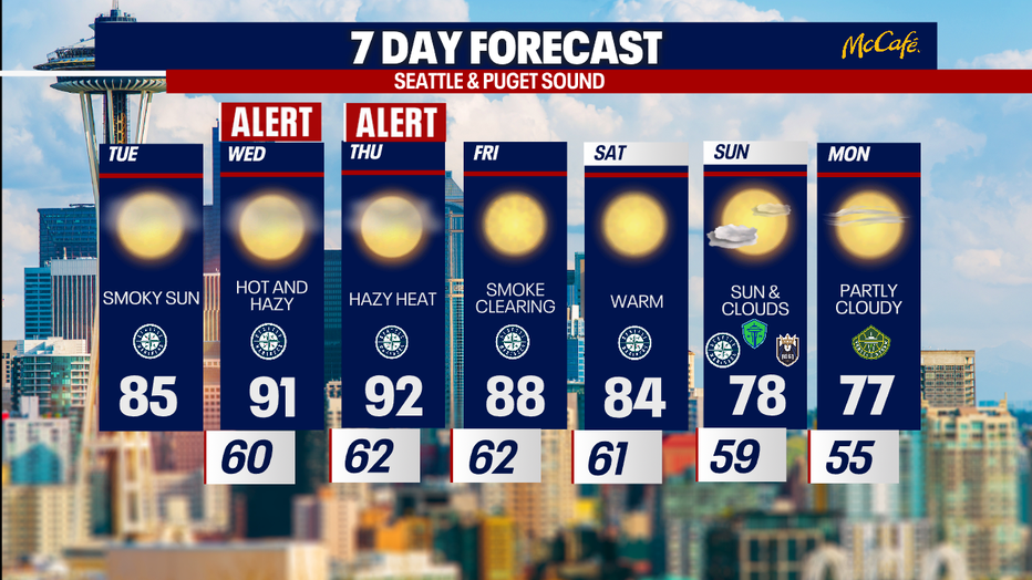
It will be hot and hazy with wildfire smoke the next three days in Seattle. (FOX 13 Seattle)
MORE NEWS FROM FOX 13 SEATTLE
LIVE: Spokane fires arrest made, zero containment, evacuations remain
Here's where fires in Washington state are burning
Man arrested for arson in Spokane, WA Old Trails Fire
Guy Fieri spotted filming 'Diners, Drive-Ins and Dives' in Ballard, WA
Wildfire smoke in Seattle: What to know as unhealthy air hits western WA
Arlington, WA families nearly struck by stray bullets during kids birthday party
To get the best local news, weather and sports in Seattle for free, sign up for the daily FOX Seattle Newsletter.
Download the free FOX LOCAL app for mobile in the Apple App Store or Google Play Store for live Seattle news, top stories, weather updates and more local and national news.
The Source: Information in this story comes from weather models interpreted by the FOX 13 Seattle weather team.