

Seattle weather: Drier, cooler weekend ahead
Seattle weather: Heavy rain wraps up first day of spring
Seattle weather: Heavy rain wraps up first day of spring
SEATTLE - The atmospheric river that’s been soaking Western Washington is finally on its way out with drier weather on tap for the weekend.
A cold front swept through Western Washington today and behind it, we will find a cooler and drier air mass. Snow levels will drop to around 3,500 to 4,000 feet, and showers will gradually taper overnight. A convergence zone may briefly set up over Snohomish County, but that should fade as we get into the overnight hours.
By Saturday morning, expect a much chillier start with lows dipping into the mid-30s to lower 40s.

It will be cooler and mainly dry Friday night in Western Washington. (FOX 13 Seattle)
Big picture view:
Several rivers remain under a Flood Warning through Saturday.

Several rivers are under Flood Warnings Friday afternoon. (FOX 13 Seattle)
Saturday brings a bit of a breather. We will keep a small chance of showers in the forecast, but most areas will stay dry for the majority of the day.

Light rain showers are possible in the Puget Sound area Saturday morning. (FOX 13 Seattle)
Snow levels continue to fall, bottoming out near 2,000 feet, but with limited moisture, mountain snowfall will be minimal. High temperatures will feel noticeably cooler, topping out in the mid-40s to low-50s.

The Cascade mountain passes will see a few light snow showers this weekend. (FOX 13 Seattle)
Mostly dry this weekend
What's next:
Saturday night, a weak system brushes the north coast, bringing the best chance for precipitation along the coastline. Inland areas will stay mostly quiet, with overnight lows in the 30s. Some of the colder spots could flirt with freezing.
By Sunday, another weak system slides by to the north, keeping a chance of light rain in the forecast. Temperatures remain on the cool side, hovering right around 50 degrees.
Looking ahead, we get a short dry break Sunday night into Monday as a weak upper-level ridge builds in. The next round of rain showers will arrive on Tuesday and Wednesday.

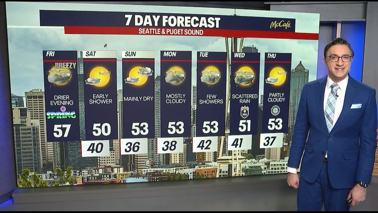
It will be more dry than wet for the next 7 days in the greater Seattle area. (FOX 13 Seattle)
MORE NEWS FROM FOX 13 SEATTLE
Gov. Ferguson signs bill changing WA legal language away from 'alien'
More than 100 Kent, WA workers to be laid off by Rise Baking
WA AG joins lawsuit against OneMain Financial, alleging bait-and-switch scheme
Chateau Ste Michelle Summer 2026 concert lineup announced
Former WA resident says she was victim of alleged License Express flaw
FBI adds WA double-murder suspect Samuel Ramirez Jr. to Most Wanted List
Loved ones still reeling after deadly Key Peninsula, WA stabbings: ‘Never saw that coming from him’
To get the best local news, weather and sports in Seattle for free, sign up for the daily FOX Seattle Newsletter.
Download the free FOX LOCAL app for mobile in the Apple App Store or Google Play Store for live Seattle news, top stories, weather updates and more local and national news.
The Source: Information in this story comes from weather models interpreted by the FOX 13 Seattle weather team.