

Seattle weather: Warmest day of the week, followed by lots of rain
Seattle weather: warmest day of the week
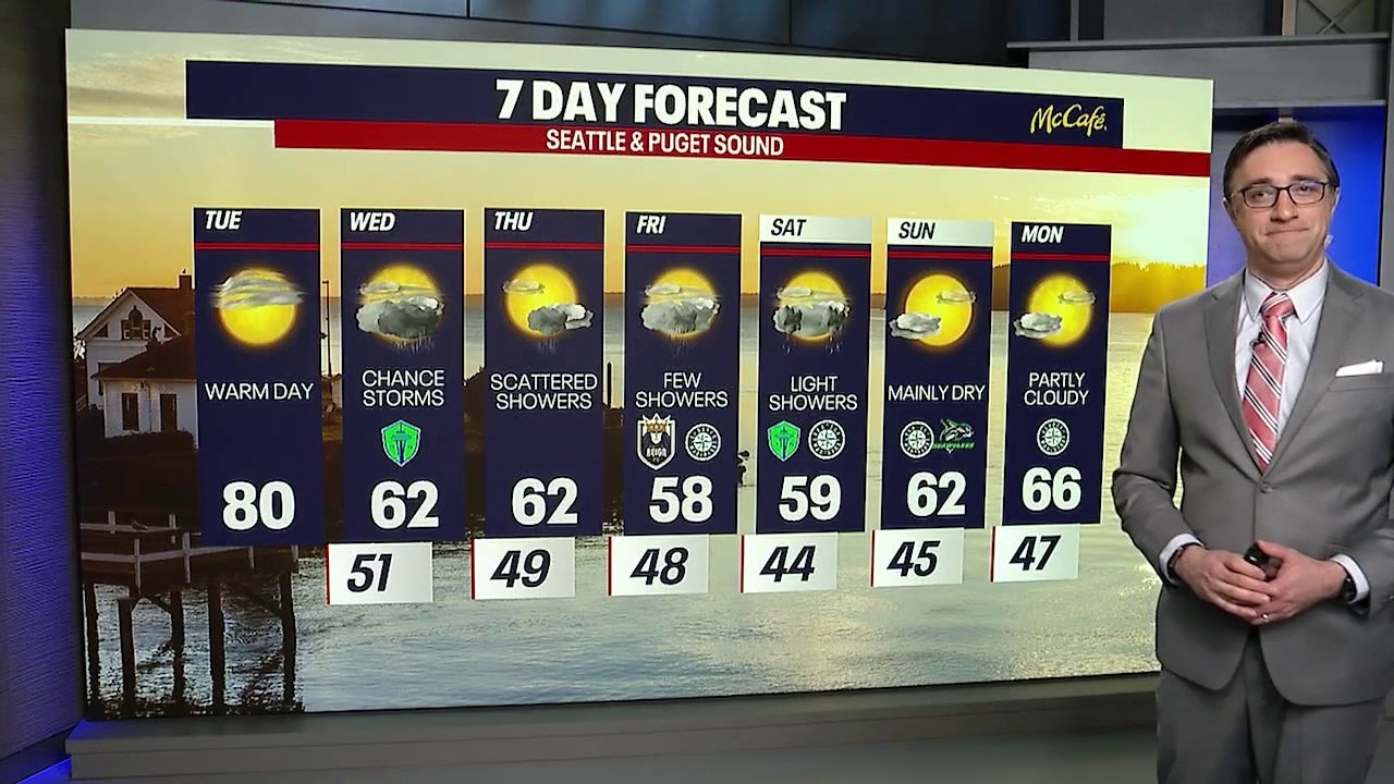
FOX 13 chief meteorologist Brian MacMillan has your seven-day forecast.
SEATTLE - After several days of warm and sunny spring weather, western Washington is about to make a dramatic turn back toward a more familiar May pattern.
Tuesday will be the last warm day before cooler marine air, clouds, and scattered showers return for the second half of the week.
Last sunny day before rain returns
After a nice warm Tuesday afternoon, changes are ahead for Tuesday evening as the ridge slides east and onshore flow pushes back into the region. You’ll likely notice cooler air moving in overnight along with increasing clouds.
There’s also a chance for scattered showers developing late Tuesday night into Wednesday, especially near the Cascades and foothills, where terrain will help enhance rainfall. A few isolated thunderstorms can’t be ruled out as well.

A low pressure system offshore will spin moisture into Western Washington on Wednesday. (FOX 13 Seattle)
Wednesday will feel much different compared to the warm weather earlier in the week. Temperatures are expected to fall back into the low 60s for most lowland areas, and scattered showers will remain in the forecast through much of the day. The best chance for rain looks to be east of Puget Sound, but a few showers are possible just about anywhere.

Rain returns early Wednesday morning in Western Washington. (FOX 13 Seattle)
Thursday brings a brief break as a weak ridge quickly moves through the region. Isolated showers are still possible with temperatures remaining cool, with highs in the low to mid 60s.
Light showers to close out the week
Looking ahead to the weekend, the overall pattern stays active. A broader trough of low pressure over the Northeast Pacific will continue sending weak weather systems into western Washington. That means additional rounds of showers are likely Friday through Sunday, along with the possibility of a few afternoon thunderstorms Friday as colder air aloft moves overhead.
The good news is there are signs conditions will begin improving early next week. Forecast models suggest showers gradually taper off by Monday as high pressure tries to rebuild. Temperatures should also start climbing again, with highs returning to the mid and upper 60s by the start of next week.

After a warm Monday, it will be much cooler the rest of the workweek in Seattle with the return of rain showers. (FOX 13 Seattle)
MORE NEWS FROM FOX 13 SEATTLE
3 names emerge as potential Seattle Seahawks buyers
Seattle man investigated after video shows him throwing rock at Hawaii monk seal
Seattle-area hit with major traffic disruptions this weekend
Eastern WA winery with 4.5M gallons engulfed in flames
Dispute over Seattle Children’s helipad noise sparks public outcry
WA's first wildfire of the season in Okanogan-Wenatchee Forest now 100% contained
Boater appeared passed out before crashing into rocks in Steilacoom
To get the best local news, weather and sports in Seattle for free, sign up for the daily FOX Seattle Newsletter.
Download the free FOX LOCAL app for mobile in the Apple App Store or Google Play Store for live Seattle news, top stories, weather updates and more local and national news.
The Source: Information in this story comes from weather models interpreted by the FOX 13 Seattle weather team.