

Seattle weather: Turning wet and breezy on Tuesday
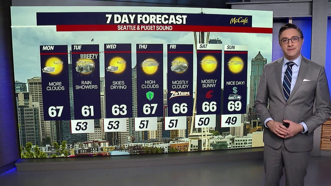
Seattle weather: Partly cloudy start to the workweek
Seattle weather: Partly cloudy start to the workweek
SEATTLE - After a quiet Monday, our weather pattern turns more active on Tuesday as the next Pacific system moves into Western Washington.
Clouds will continue increasing this afternoon ahead of the system, with a chance of rain developing along the north coast late in the day. Temperatures will still reach the mid 60s.
Changes arrive tonight and early Tuesday. Rain will spread into the north coast and Northwest Interior around midnight, with showers potentially reaching as far south as Olympia by early Tuesday morning. The increasing cloud cover will keep temperatures milder overnight, with lows in the low to mid-50s.
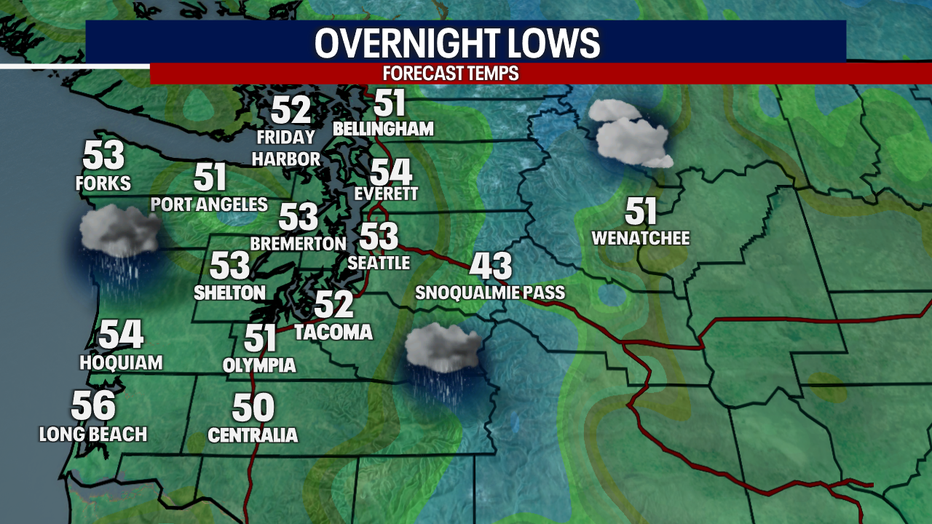
Overnight lows Monday night will be more mild as clouds and rain hit Western Washington. (FOX 13 Seattle)
Gusty winds Tuesday morning
Big picture view:
A Wind Advisory is in effect for parts of Western Whatcom County and San Juan Islands beginning at 2:00 AM on Tuesday. Southeast winds are expected to increase to 20 to 30 mph, with gusts of 40 to 45 mph possible. The strongest winds will hit as the front approaches Tuesday morning. Winds should ease after the front passes in the afternoon.
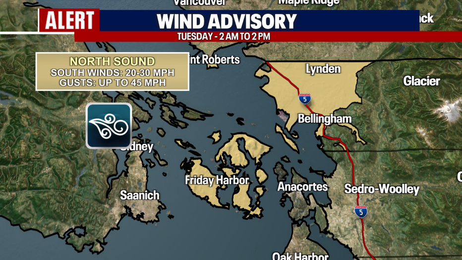
A Wind Advisory is in effect Tuesday morning through the early afternoon in the north Puget Sound area. (FOX 13 Seattle)
By Tuesday morning, rain will be falling across much of Western Washington. Expect on and off showers for most Puget Sound area locations through the late afternoon. Highs will only reach the low to mid-60s.
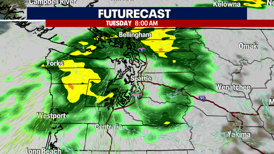
Widespread rain showers return to Western Washington Tuesday morning. (FOX 13 Seattle)
The front will pass through Tuesday evening, bringing an end to the widespread rain, but a convergence zone will develop around the Snohomish County/King County line Tuesday evening, keeping the area wet longer into the evening.
Drier, warmer weather makes a return
What's next:
Wednesday looks much better. High pressure will rebuild over Western Washington, bringing increasing sunshine. Patchy fog could develop early Wednesday morning, but whatever forms should burn off by mid-morning. After that, expect plenty of sunshine with highs in the lower to mid-60s.
Thursday and Friday will remain dry and mild with a mix of clouds and sunshine. By the weekend, temperatures will warm even more.
Saturday temperatures should reach the 60s and low 70s. We could see plenty of spots in the low 70s on Sunday.
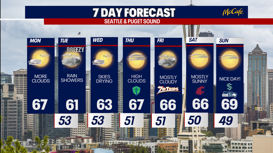
After a stormy Tuesday, the rest of the week looks drier and warmer in Seattle. (FOX 13 Seattle)
MORE NEWS FROM FOX 13 SEATTLE
Dan Wilson will not return as Seattle Mariners manager
6 WA Starbucks locations closing amid broader shutdown. Here's where
Seattle police, city leaders push back on Mayor Wilson's proposed budget
Kurt Cobain's Nirvana studio hits Airbnb in Olympia, WA
Puyallup, WA realtor couple, neighbor share story behind viral TikTok
New Amtrak Airo trains to debut Sept. 30 in the Pacific Northwest
1,150-acre Benton County fire prompts evacuation orders
To get the best local news, weather and sports in Seattle for free, sign up for the daily FOX Seattle Newsletter.
Download the free FOX LOCAL app for mobile in the Apple App Store or Google Play Store for live Seattle news, top stories, weather updates and more local and national news.
The Source: Information in this story comes from weather models interpreted by the FOX 13 Seattle weather team.